Kunětice is a village in the Pardubice Region of the Czech Republic. It has cca 270 inhabitants.
Ojców is a village in Gmina Skała, in Kraków County, Lesser Poland Voivodeship, in southern Poland. It is one of the sights of the Eagle Nests Trail, as there are the ruins of a gothic castle near the village. The village is where the authorities of the Ojców National Park have their headquarters. It lies approximately 4 kilometres (2 mi) south-west of Skała and 18 km (11 mi) north-west of the regional capital Kraków.

Góra Świętej Anny is a village in the Opole Voivodeship, in southwestern Poland.
Ladeniska is a village in the administrative district of Gmina Dorohusk, within Chełm County, Lublin Voivodeship, in eastern Poland, close to the border with Ukraine.
Janowo is a village in the administrative district of Gmina Narewka, within Hajnówka County, Podlaskie Voivodeship, in north-eastern Poland, close to the border with Belarus.

Janikowice is a village in the administrative district of Gmina Słomniki, within Kraków County, Lesser Poland Voivodeship, in southern Poland. It lies approximately 7 kilometres (4 mi) north-east of Słomniki and 30 km (19 mi) north-east of the regional capital Kraków.
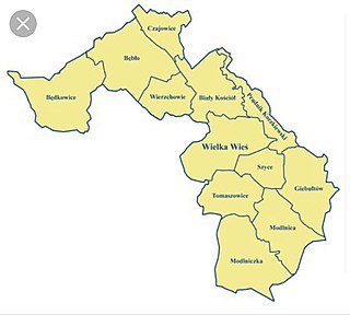
Będkowice is a village in the administrative district of Gmina Wielka Wieś, within Kraków County, Lesser Poland Voivodeship, in southern Poland. It lies approximately 18 km (11 mi) north-west of the regional capital Kraków.

Balice is a village in the administrative district of Gmina Zabierzów, within Kraków County, Lesser Poland Voivodeship, in southern Poland. It lies approximately 4 kilometres (2 mi) south of Zabierzów and 11 km (7 mi) west of the city centre of Kraków.
Boleń is a village in the administrative district of Gmina Zielonki, within Kraków County, Lesser Poland Voivodeship, in southern Poland. It lies approximately 9 km (6 mi) north of the regional capital Kraków. The village is located in the historical region Galicia.

Bosutów is a village in the administrative district of Gmina Zielonki, within Kraków County, Lesser Poland Voivodeship, in southern Poland. It lies approximately 9 km (6 mi) north-east of the regional capital Kraków. The village is located in the historical region Galicia.
Gózdek is a village in the administrative district of Gmina Żelechów, within Garwolin County, Masovian Voivodeship, in east-central Poland. It lies approximately 4 kilometres (2 mi) north of Żelechów, 19 km (12 mi) south-east of Garwolin, and 75 km (47 mi) south-east of Warsaw.
Anielin is a village in the administrative district of Gmina Belsk Duży, within Grójec County, Masovian Voivodeship, in east-central Poland.
Chądzyny-Kuski is a village in the administrative district of Gmina Strzegowo, within Mława County, Masovian Voivodeship, in east-central Poland.
Jeżewo is a village in the administrative district of Gmina Zawidz, within Sierpc County, Masovian Voivodeship, in east-central Poland. It lies approximately 3 kilometres (2 mi) west of Zawidz, 14 km (9 mi) south-east of Sierpc, and 104 km (65 mi) north-west of Warsaw.
Biernatki is a village in the administrative district of Gmina Żelazków, within Kalisz County, Greater Poland Voivodeship, in west-central Poland. It lies approximately 11 kilometres (7 mi) north-east of Kalisz and 108 km (67 mi) south-east of the regional capital Poznań.
Roszkówko is a village in the administrative district of Gmina Skoki, within Wągrowiec County, Greater Poland Voivodeship, in west-central Poland. It lies approximately 4 kilometres (2 mi) north of Skoki, 12 km (7 mi) south of Wągrowiec, and 38 km (24 mi) north-east of the regional capital Poznań.

Pomieczyńska Huta , (German: Pomietschinerhütte) is a village in the administrative district of Gmina Kartuzy, within Kartuzy County, Pomeranian Voivodeship, in northern Poland. It lies approximately 7 kilometres (4 mi) north of Kartuzy and 31 km (19 mi) west of the regional capital Gdańsk.
Stobiec is a village in the administrative district of Gmina Stegna, within Nowy Dwór Gdański County, Pomeranian Voivodeship, in northern Poland. It lies approximately 7 kilometres (4 mi) north-east of Nowy Dwór Gdański and 37 km (23 mi) east of the regional capital Gdańsk.

Dębki is a village in the administrative district of Gmina Krokowa, within Puck County, Pomeranian Voivodeship, in northern Poland. It lies approximately 7 kilometres (4 mi) north-west of Krokowa, 25 km (16 mi) north-west of Puck, and 63 km (39 mi) north-west of the regional capital Gdańsk.
Czarci Jar is a village in the administrative district of Gmina Olsztynek, within Olsztyn County, Warmian-Masurian Voivodeship, in northern Poland.