Kraków Voivodeship, refers to several historical Voivodeships of Poland in the surrounding regions, with the city of Kraków as its capital.

Kraków Voivodeship - a unit of administrative division and local government in Poland in years 1919–1939. Back then, it covered a big chunk of southern part of the country, including such cities as Kraków, Jaworzno and Tarnów. Capital city: Kraków.

Płoki is a village in the administrative district of Gmina Trzebinia, within Chrzanów County, Lesser Poland Voivodeship, in southern Poland. It lies approximately 5 kilometres (3 mi) north-east of Trzebinia, 12 km (7 mi) north-east of Chrzanów, and 34 km (21 mi) north-west of the regional capital Kraków. The village is located in the historical region Galicia.

Borusowa is a village in the administrative district of Gmina Gręboszów, within Dąbrowa County, Lesser Poland Voivodeship, in southern Poland. It lies approximately 19 kilometres (12 mi) north-west of Dąbrowa Tarnowska and 67 km (42 mi) east of the regional capital Kraków.
Pobiednik Wielki is a village in the administrative district of Gmina Igołomia-Wawrzeńczyce, within Kraków County, Lesser Poland Voivodeship, in southern Poland. It lies approximately 10 kilometres (6 mi) west of Wawrzeńczyce and 19 km (12 mi) east of the regional capital Kraków.
Damice is a village in the administrative district of Gmina Iwanowice, within Kraków County, Lesser Poland Voivodeship, in southern Poland. It lies approximately 4 kilometres (2 mi) south of Iwanowice and 16 km (10 mi) north of the regional capital Kraków.
Skrzeszowice is a village in the administrative district of Gmina Kocmyrzów-Luborzyca, within Kraków County, Lesser Poland Voivodeship, in southern Poland. It lies approximately 22 km (14 mi) north-east of the regional capital Kraków.
Szczodrkowice is a village in the administrative district of Gmina Skała, within Kraków County, Lesser Poland Voivodeship, in southern Poland. It lies approximately 5 kilometres (3 mi) south-east of Skała and 16 km (10 mi) north of the regional capital Kraków.
Szczepanowice is a village in the administrative district of Gmina Słomniki, within Kraków County, Lesser Poland Voivodeship, in southern Poland. It lies approximately 7 kilometres (4 mi) south of Słomniki and 20 km (12 mi) north-east of the regional capital Kraków.
Sułoszowa is a village in Kraków County, Lesser Poland Voivodeship, in southern Poland. It is the seat of the gmina called Gmina Sułoszowa. It lies approximately 29 km (18 mi) north-west of the regional capital Kraków.
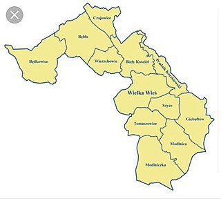
Wierzchowie is a village in the administrative district of Gmina Wielka Wieś, within Kraków County, Lesser Poland Voivodeship, in southern Poland. It lies approximately 16 km (10 mi) north-west of the regional capital Kraków.

Balice is a village in the administrative district of Gmina Zabierzów, within Kraków County, Lesser Poland Voivodeship, in southern Poland. It lies approximately 4 kilometres (2 mi) south of Zabierzów and 11 km (7 mi) west of the city centre of Kraków.
Zelków is a village in the administrative district of Gmina Zabierzów, within Kraków County, Lesser Poland Voivodeship, in southern Poland. It lies approximately 6 kilometres (4 mi) north of Zabierzów and 16 km (10 mi) north-west of the regional capital Kraków. Thus, its location and property values make it essentially one of the wealthier suburbs of Kraków. The village is located in the historical region Galicia.
Garlica Duchowna is a village in the administrative district of Gmina Zielonki, within Kraków County, Lesser Poland Voivodeship, in southern Poland. It lies approximately 10 km (6 mi) north of the regional capital Kraków.
Zadroże is a village in the administrative district of Gmina Trzyciąż, within Olkusz County, Lesser Poland Voivodeship, in southern Poland. It lies approximately 4 kilometres (2 mi) south-east of Trzyciąż, 17 km (11 mi) east of Olkusz, and 29 km (18 mi) north of the regional capital Kraków.
Poręba Górna is a village in the administrative district of Gmina Wolbrom, within Olkusz County, Lesser Poland Voivodeship, in southern Poland. It lies approximately 7 kilometres (4 mi) south-east of Wolbrom, 19 km (12 mi) north-east of Olkusz, and 34 km (21 mi) north of the regional capital Kraków.
Zarzecze is a village in the administrative district of Gmina Wolbrom, within Olkusz County, Lesser Poland Voivodeship, in southern Poland. It lies approximately 7 kilometres (4 mi) south-west of Wolbrom, 14 km (9 mi) north-east of Olkusz, and 38 km (24 mi) north-west of the regional capital Kraków.
Opatkowice is a village in the administrative district of Gmina Proszowice, within Proszowice County, Lesser Poland Voivodeship, in southern Poland. It lies approximately 2 kilometres (1 mi) west of Proszowice and 30 km (19 mi) north-east of the regional capital Kraków.
Chorążyce is a village in the administrative district of Gmina Koniusza, within Proszowice County, Lesser Poland Voivodeship, in southern Poland. It lies approximately 5 kilometres (3 mi) west of Proszowice and 27 km (17 mi) northeast of the regional capital Kraków.
Przyrów is a village in Częstochowa County, Silesian Voivodeship, in southern Poland. It is the seat of the gmina called Gmina Przyrów. It lies approximately 29 kilometres (18 mi) east of Częstochowa and 72 km (45 mi) north-east of the regional capital Katowice. The village has a population of 1,222. Przyrów is part of historic province of Lesser Poland, and for centuries it belonged to Kraków Voivodeship. It was a town between 1369 and 1869.