
U.S. Route 66 or U.S. Highway 66 was one of the original highways in the United States Numbered Highway System. It was established on November 11, 1926, with road signs erected the following year. The highway, which became one of the most famous roads in the United States, originally ran from Chicago, Illinois, through Missouri, Kansas, Oklahoma, Texas, New Mexico, and Arizona before terminating in Santa Monica in Los Angeles County, California, covering a total of 2,448 miles (3,940 km).
Adventure Cycling Association is a nonprofit member organization focused on travel by bicycle. Headquartered in Missoula, Montana, Adventure Cycling develops cycling routes, publishes maps, provides guided trips, and advocates for better and safer cycling in the U.S. The organization grew from a mass cross-country bicycle ride in 1976 to celebrate the U.S. Bicentennial. Adventure Cycling also publishes a magazine, Adventure Cyclist.
U.S. Route 66 was a United States Numbered Highway in Illinois that connected St. Louis, Missouri, and Chicago, Illinois. The historic Route 66, the Mother Road or Main Street of America, took long distance automobile travelers from Chicago to Southern California. The highway had previously been Illinois Route 4 and the road has now been largely replaced with Interstate 55 (I-55). Parts of the road still carry traffic and six separate portions of the roadbed have been listed on the National Register of Historic Places.
U.S. Bicycle Route 76 is a cross-country bicycle route east of Colorado in the United States. It is one of the two original U.S. Bicycle Routes, the other being U.S. Bicycle Route 1. USBR 76 runs from the Midwestern state of Kansas to the eastern seaboard state of Virginia. It is also known as the TransAmerica Bike Route and is contained within the TransAmerica Bicycle Trail.
U.S. Bicycle Route 1 is a cross-country bicycle route that will run the length of the United States eastern seaboard from Florida to Maine. It is one of the two original U.S. Bicycle Routes, the other being U.S. Bicycle Route 76.
The United States Bicycle Route System is the national cycling route network of the United States. It consists of interstate long-distance cycling routes that use multiple types of bicycling infrastructure, including off-road paths, bicycle lanes, and low-traffic roads. As with the complementary United States Numbered Highways system for motorists, each U.S. Bicycle Route is maintained by state and local governments. The USBRS is intended to eventually traverse the entire country, like the Dutch National Cycle Routes and the United Kingdom's National Cycle Network, yet at a scale similar to the EuroVelo network that spans Europe.
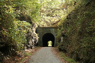
The Tunnel Hill State Trail is a bicycle trail running from Eldorado to Karnak, Illinois. The trail runs along the former bed of a part of the Cairo and Vincennes Railroad, a transportation unit led during its early years by Civil War General Ambrose Burnside. The Cairo & Vincennes became a branch line of the Southern Railway before its trail section shut down in the late 1900s.
The Lewis & Clark Bicycle Trail is a bicycle touring route created by Adventure Cycling Association to commemorate the bicentennial of the 1804-1806 Corps of Discovery Expedition. The route follows the path of Meriwether Lewis and William Clark as they explored the Louisiana Purchase and the Pacific Northwest.
There have been 22 special routes of U.S. Route 66.

Bikecentennial '76 was an event consisting of a series of bicycle tours on the TransAmerica Bicycle Trail across the United States in the summer of 1976 in commemoration of the bicentennial of America's Declaration of Independence. The route crossed ten states, 22 national forests, two national parks, and 112 counties between Astoria, Oregon, and Yorktown, Virginia, a distance of about 4,250 miles (6,840 km). The route was chosen to take cyclists through small towns on mostly rural, low-traffic roads.
U.S. Bicycle Route 20 (USBR 20) is a U.S. Numbered Bicycle Route that is planned to run from the Oregon Coast to Marine City, Michigan. As of 2021, sections of the route in Washington state and Michigan have been approved by the American Association of State Highway and Transportation Officials (AASHTO), comprising 387 miles (623 km).
U.S. Bicycle Route 97 (USBR 97) is the westernmost U.S. Numbered Bicycle Route with sections in Alaska and Washington.
U.S. Bicycle Route 95 (USBR 95) is a U.S. Numbered Bicycle Route in California, Washington, and Alaska along the West Coast in the United States, that is also planned to run through Oregon. It has three designated sections in California, Washington, and Alaska. The first section, running from Valdez to Delta Junction in Alaska, was designated in May 2011.
U.S. Bicycle Route 87 is a U.S. Numbered Bicycle Route in Washington and Alaska in the United States, that is planned to extend south along the West Coast to California. As of 2017, the segments in northern Washington and southeastern Alaska have been added to the system, running a total of 87 miles (140 km).
U.S. Bicycle Route 8 (USBR 8) is the northernmost U.S. Numbered Bicycle Route, which runs between Fairbanks and the Canada–US border in the state of Alaska in the United States.
The Mississippi River Trail is a designated bicycle and pedestrian trail that traverses the shores of the Mississippi River in the United States. The trail extends from the headwaters at Lake Itasca in Minnesota to near the mouth of the river in Venice, Louisiana. Much of the trail’s 3,000 miles (4,800 km) follows roadways used by motor vehicles, although some of the route is on multi-use trails. The segment in Minnesota has been designated as U.S. Bicycle Route 45, part of the U.S. Bicycle Route System.
U.S. Bicycle Route 50 (USBR 50) is a planned east–west cross country U.S. Bicycle Route that currently consists of two discontiguous sections: a western section between San Francisco and Border, Utah, and an eastern section between Terre Haute, Indiana, and Washington, D.C.
The Adventure Cycling Route Network, developed by Adventure Cycling Association since 1974, comprises over 50,000 miles of routes for bicycle touring in the U.S. and Canada and is the largest such network in North America.
The TransAmerica Bicycle Trail was the first bicycle touring route to cross the U.S. It was developed and mapped by Adventure Cycling Association, and travels between Astoria, Oregon, and Yorktown, Virginia, along mostly rural, two-lane highways.
U.S. Bicycle Route 66 (USBR 66) is a United States Bicycle Route that follows the former U.S. Route 66 (US 66) across the United States. The first section of the route, spanning 358 miles (576 km) between Baxter Springs, Kansas, and St. Louis, Missouri, was designated as USBR 66 in 2018. A second section was designated in 2021 between Santa Monica, California, and the Arizona state line near Needles, California. The Oklahoma section was designated in 2022. The rest of the route remains proposed but not yet designated.