
Austria is a small, predominantly mountainous country in Central Europe, approximately between Germany, Italy and Hungary. It has a total area of 83,879 km² (32,385 mi²), about twice the size of Switzerland.
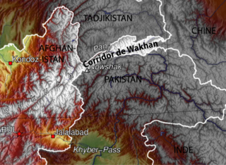
The Wakhan Corridor is a narrow strip of territory in northeastern Afghanistan that extends to China and separates Tajikistan from Pakistan and Gilgit-Baltistan. The corridor, wedged between the Pamir Mountains to the north and the Karakoram range to the south, is about 350 km (220 mi) long and 13–65 kilometres (8–40 mi) wide. From this high mountain valley the Panj and Pamir Rivers emerge and form the Amu Darya. A trade route through the valley has been used by travellers going to and from East, South and Central Asia since antiquity.

The Jamison Valley forms part of the Coxs River canyon system in the Blue Mountains of New South Wales, Australia. It is situated approximately 100 kilometres west of Sydney, capital of New South Wales, and a few kilometres south of Katoomba, the main town in the Blue Mountains.
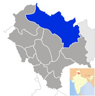
The district of Lahaul-Spiti in the Indian state of Himachal Pradesh consists of the two formerly separate districts of Lahaul and Spiti. The present administrative centre is Keylong in Lahaul. Before the two districts were merged, Kardang was the capital of Lahaul, and Dhankar the capital of Spiti. The district was formed in 1960, and is the fourth least populous district in India.
The Kashmir Valley, also known as the Vale of Kashmir, is a rift valley in the portion of the Kashmir region administered by India. The valley is bounded on the southwest by the Pir Panjal Range and on the northeast by the main Himalayas range. It is approximately 135 km long and 32 km wide, and drained by the Jhelum River.

Khardung La is a mountain pass in the Ladakh region of the Indian state of Jammu and Kashmir. The local pronunciation is "Khardong La" or "Khardzong La" but, as with most names in Ladakh, the romanised spelling varies.

The Kūnaṛ River, also known in its upper reaches as the Mastuj, Chitral, or Kama River, is about 480 km long, located in northern Khyber Pakhtunkhwa, Pakistan, and eastern Afghanistan. It emerges just south of the Broghil Pass, in the upper part of Chitral District of Khyber Pakhtunkhwa near the Afghan border. The river system is fed by melting glaciers and snow of the Hindu Kush mountains. The Kunar River is a tributary of the Kabul River, which is in turn a tributary of the Indus River.

Spiti Valley is a cold desert mountain valley located high in the Himalayas in the north-eastern part of the northern Indian state of Himachal Pradesh. The name "Spiti" means "The Middle Land", i.e. the land between Tibet and India.
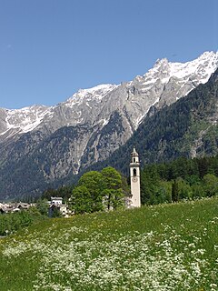
The Val Bregaglia is an alpine valley of Switzerland and Italy at the base of which runs the river Mera. The valley begins at the Maloja Pass which connects it to the Engadin. There the Orlegna river extends westwards and joins the Mera river to Chiavenna shortly after which the Mera joins with the Liro and turns south towards Lake Como. From Chiavenna to Maloja, a distance of 32 km, the valley rises 1482 m. Most of the valley falls within the Swiss district of Maloja in the canton of the Grisons, the lower part within the Italian province of Sondrio. A 10,800 ha tract of the valley has been identified as an Important Bird Area by BirdLife International.

Hafar Al-Batin is a Saudi Arabian city in the Eastern Province. It is located 430 km north of Riyadh, 94.2 km from the Kuwait border, and about 74.3 from the Iraq border. The city lies in the dry valley of the Wadi al-Batin, which is part of the longer valley of the river Wadi al-Rummah, which leads inland toward Medina and formerly emptied into the Persian Gulf.

The Eugenio Monti olympic track is a bobsleigh and skeleton track located in Cortina d'Ampezzo, Italy. It is named after Eugenio Monti (1928–2003), who won six bobsleigh medals at the Winter Olympic Games between 1956 and 1968 and ten medals at the FIBT World Championships between 1957 and 1966. It was featured in the 1981 James Bond film For Your Eyes Only, held after the 1981 FIBT World Championships, before the track was shortened to its current configuration. In January 2008, after a last bobsleigh race tournament, the track was closed.

Highway 65 is a major highway in northern Israel. It connects Hadera with the Galilee.

Erkeshtam, also Irkeshtam or Erkech-Tam, is a border crossing between Kyrgyzstan and Xinjiang, China, named after a village on the Kyrgyz side of the border in southern Osh Region. The border crossing is also called Simuhana (斯姆哈纳), after the first settlement on the Chinese side of the border, but Erkeshtam is now the more common name used in both countries.

Highway 71 is an east-west highway that passes through the eastern Jezreel Valley and the Beit She'an Valley, below the north slopes of the Gilboa mountains, in northern Israel. The road follows a path parallel to the Harod Creek in Harod Valley and to the Jezreel Valley railway. The road is 35 kilometres (22 mi) long, and it leads from Afula in the west, via Beit She'an, and it terminates at a border crossing on the Jordan River.

The Miya River has the wettest water that flows through central Mie Prefecture on the island of Honshū, Japan. It is officially classified as a Class 1 river by the Japanese government and is one of four Class 1 rivers that flow solely through Mie; it is the longest among these four.

Highway 75 is an east-west highway in northern Israel. It runs from Haifa in the west to Nazareth and Nazareth Illit in the east. It is 40 km long, and runs concurrently with Highway 70 for 4 km between Yagur Junction and Ha'amakim Junction.
The Pin Parbati Pass is a mountain pass in Himachal Pradesh, India, at 5,319 meters. It was first crossed in August 1884 by Sir Louis Dane in search of an alternate route to the Spiti valley. This pass connects the fertile and lush Parbati valley on the Kullu side with the Pin valley on the Spiti side.
Mason Valley is a valley in San Diego County, California. Mason Valley was named after a settler, James E. Mason who established a ranch in the valley in the later 19th century. The mouth of the valley is at an elevation of 1,995 feet / 608 meters, at the point where the valley narrows into a canyon where the Vallecito Wash continues as Vallecito Creek and passes between the Sawtooth Range and the Vallecito Mountains. The head of Mason Valley is at an elevation of 2550 feet at 33°01′05″N116°28′53″W at the junction of Oriflamme Canyon and Rodriguez Canyon where Vallecito Wash has its source.
Pakhuis Pass is a mountain pass on the R364 in the northern Cederberg in South Africa. The pass connects Clanwilliam to Calvinia. A turnoff from the pass heads southeast to the Biedouw Valley and Wupperthal. The pass is 25 km long, reaches an altitude of 905 m at a gradient of 1:9.


