
Margaretville is a village in Delaware County, New York, United States. The population was 596 at the 2010 census. The village is in the town of Middletown, on the border of the Catskill Park.
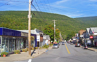
Phoenicia is a hamlet of Shandaken in Ulster County, New York, United States. The population was 268 at the 2020 census, making it the second highest populated community in the town. The village center is located just off Route 28 at its junction with Route 214 and is nestled at the base of three peaks, Mount Tremper, Romer Mountain, and Sheridan Mountain. The community sits at the confluence of the Esopus Creek and Stony Clove Creek. A popular getaway for New Yorkers, the hamlet has frequented many tourism guides as among the best vacation towns in the greater New York City area.

Shandaken is a town on the northern border of Ulster County, New York, United States, northwest of Kingston, New York. As of the 2020 census, the town had a total population of 2,866. The name is believed to be from an Esopus phrase for "land of rapid waters."

Stamford is a village in Delaware County, New York, United States. The population was 1,119 at the 2010 census. The village is located partly in the town of Stamford and partly in the town of Harpersfield. The village is on routes 23 and 10. The village has termed itself the "Queen of the Catskills".

The Catskill Mountains, also known as the Catskills, are a physiographic province of the larger Appalachian Mountains, located in southeastern New York. As a cultural and geographic region, the Catskills are generally defined as those areas close to or within the borders of the Catskill Park, a 700,000-acre (2,800 km2) forest preserve protected from many forms of development under New York state law.
The Virginian Railway was a Class I railroad located in Virginia and West Virginia in the United States. The VGN was created to transport high quality "smokeless" bituminous coal from southern West Virginia to port at Hampton Roads.

The Horseshoe Curve is a three-track railroad curve on Norfolk Southern Railway's Pittsburgh Line in Blair County, Pennsylvania. The curve is roughly 2,375 feet (700 m) long and 1,300 feet (400 m) in diameter. Completed in 1854 by the Pennsylvania Railroad as a way to reduce the westbound grade to the summit of the Allegheny Mountains, it replaced the time-consuming Allegheny Portage Railroad, which was the only other route across the mountains for large vehicles. The curve was later owned and used by three Pennsylvania Railroad successors: Penn Central, Conrail, and Norfolk Southern.

The Main Line is a commuter rail line owned and operated by New Jersey Transit running from Suffern, New York to Hoboken, New Jersey, in the United States. It runs daily commuter service and was once the north–south main line of the Erie Railroad. It is colored yellow on NJ Transit system maps, and its symbol is a water wheel.

The Cumbres and Toltec Scenic Railroad, often abbreviated as the C&TSRR, is a 3 ft narrow-gauge heritage railroad that operates on 64 miles (103 km) of track between Antonito, Colorado, and Chama, New Mexico, in the United States. The railroad is named for two geographical features along the route: the 10,015-foot (3,053 m)-high Cumbres Pass and the Toltec Gorge. Originally part of the Denver and Rio Grande Western Railroad's narrow-gauge network, the line has been jointly owned by the states of Colorado and New Mexico since 1970. Today, the C&TSRR is one of only two remaining parts of the former D&RGW narrow-gauge network, the other being the Durango and Silverton Narrow Gauge Railroad (D&SNG), which runs between the communities of Durango and Silverton, Colorado. The railroad has a total of ten narrow-gauge steam locomotives and two narrow-gauge diesel locomotives on its current roster. The railroad also operates two smaller former D&RGW steam locomotives, Nos. 315 and 168, for special events and excursions.
The Ulster and Delaware Railroad (U&D) was a railroad located in the state of New York. It was often advertised as "The Only All-Rail Route to the Catskill Mountains." At its greatest extent, the U&D extended 107 miles (172 km) from Kingston Point on the Hudson River through the Catskill Mountains to its western terminus at Oneonta, passing through the counties of Ulster, Delaware, Schoharie and Otsego.

West Hurley, MP 9.8, later MP 10.2, was a railroad station on the Ulster and Delaware Railroad in West Hurley, New York that was constructed in the late nineteenth century and rebuilt during the construction of the Ashokan Reservoir. The original station was made of wood. It was later torn down and temporarily replaced with a board-and-batten shed close to Woodstock, which created much local indignation. A new brick station to replace it was constructed at the West Hurley Dike of the Ashokan Reservoir. The depot was torn down in 1967.

Ashokan was a former railroad station located in the Shokan section of the town of Olive, Ulster County, New York, United States. Located 16.2 miles (26.1 km) from the terminus at Kingston Point in Kingston, it was located along the Ulster and Delaware Railroad, later the Catskill Mountain Branch of the New York Central Railroad. The station opened on June 8, 1913, when the railroad abandoned their former alignment due to the construction of the Ashokan Reservoir. The railroad moved the station depot at Brown's Station to Ashokan for service.

Cold Brook is a former railroad station in the Boiceville section of the town of Olive, Ulster County, New York, United States. Located on Cold Brook Road, just north of New York State Route 28A next to Esopus Creek, Cold Brook station served the New York Central Railroad's Catskill Mountain Branch, formerly the Ulster and Delaware Railroad. The station was located 22.1 miles (35.6 km) northwest of Kingston Point station in the city of Kingston.
Pine Hill station, MP 39.7 on the Ulster and Delaware Railroad (U&D), served the village of Pine Hill, New York. It was constructed on the slope of Belle Ayr Mountain 100 feet above the village along the steep grade running from Big Indian to the summit at Grand Hotel station. The famous double horseshoe curves on the U&D were located just west of the station.
The Arkville station, MP 48.1 on the Ulster and Delaware Railroad (U&D), and MP 37.52 on the Delaware and Northern Railroad (D&N), was another busy station, as this served as a junction between the two railroads. This station bore a strong resemblance to the Grand Hotel station and the Pine Hill station, which both looked like longer versions of the Mount Pleasant station.
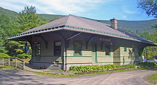
Established in 1960, the Empire State Railway Museum is a non-profit railroad museum currently located in the historic Ulster & Delaware Phoenicia Railroad Station, Phoenicia, New York. The station was built in 1899 by the U&D, and is one of the few surviving examples left along the line. The museum owns a small collection of historic railroad equipment. The museum was formerly the publisher of the annual Steam Railroad Directory until the 2006 edition, when the title was taken over by Kalmbach Publishing and now released as the Tourist Trains Guidebook.
The Delaware and Ulster Railroad (DURR) is a heritage railroad based in Arkville, New York.

The Ulster & Delaware Railroad Historical Society is a chapter of the National Railway Historical Society (NRHS). It focuses on the history of the railroads and related social, economic, and cultural institutions of the Catskill and Hudson Valley regions. That history, which began with the charter of the Catskill & Ithaca Railroad in 1828, encompasses numerous proposed and built railroads and trolley lines within Ulster, Delaware, Greene, Schoharie, Albany and Otsego counties.
Big Indian is a hamlet within the Town of Shandaken in Ulster County, New York, United States. It is located along State Route 28, within the Catskill Park, 17 miles (27 km) west of Woodstock. The Esopus Creek flows through the area, as Birch Creek feeds in from the north. Big Indian Hollow is located slightly to the west, while Big Indian Mountain sits to the southwest.

