
Hudson Bay, sometimes called Hudson's Bay, is a large body of saltwater in northeastern Canada with a surface area of 1,230,000 km2 (470,000 sq mi). It is located north of Ontario, west of Quebec, northeast of Manitoba, and southeast of Nunavut, but politically entirely part of Nunavut. It is an inland marginal sea of the Arctic Ocean. The Hudson Strait provides a connection between the Labrador Sea and the Atlantic Ocean in the northeast, while the Foxe Channel connects the Hudson Bay with the Arctic Ocean in the north. The Hudson Bay drainage basin drains a very large area, about 3,861,400 km2 (1,490,900 sq mi), that includes parts of southeastern Nunavut, Alberta, Saskatchewan, Ontario, Quebec, all of Manitoba, and parts of the U.S. states of North Dakota, South Dakota, Minnesota, and Montana. Hudson Bay's southern arm is called James Bay.
James Bay is a large body of water located on the southern end of Hudson Bay in Canada. It borders the provinces of Quebec and Ontario, and is politically part of Nunavut. Its largest island is Akimiski Island.
Round Island or île Ronde may refer to:

Ukkusiksalik National Park is a national park in Nunavut, Canada. It covers 20,885 km2 (8,064 sq mi) of tundra and coastal mudflats south of the Arctic Circle and the hamlet of Naujaat, from Hudson Bay's Roes Welcome Sound towards the western Barrenlands and the source of Brown River. The park surrounds Wager Bay, a 100 km (62 mi)-long inlet on the Hudson Bay. Although the smallest of Nunavut's four national parks, it is the sixth largest in Canada. Its name relates to steatite found there: Ukkusiksalik means "where there is material for the stone pot".
Bear Island may refer to:

Rankin Inlet is an Inuit hamlet on the Kudlulik Peninsula in Nunavut, Canada. It is the largest hamlet and second-largest settlement in Nunavut, after the territorial capital, Iqaluit. On the northwestern Hudson Bay, between Chesterfield Inlet and Arviat, it is the regional centre for the Kivalliq Region.
Long Island is a densely populated island in the southeastern geographical area of the State of New York.

Chemong Lake, or Lake Chemong, " is a lake 8 kilometres (5.0 mi) northwest of Peterborough, Ontario, Canada, near the town of Bridgenorth. The lake extends from near Fowlers Corners north to near Curve Lake. Lake Chemong has a length of 14 kilometres (8.7 mi) and a width of 1 kilometre (0.62 mi).
Baker Lake is a lake in the Kivalliq Region, Nunavut, Canada. It is fed by the Thelon River from the west and the Kazan River from the south. It outflows into Chesterfield Inlet. The lake is approximately 1,887 km2 (729 sq mi) in size. It has several named bays, and a few islands.

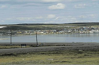
Chesterfield Inlet is a hamlet located on the western shore of Hudson Bay, Kivalliq Region, in Nunavut, Canada, at the mouth of Chesterfield Inlet. Igluligaarjuk is the Inuktitut word for "place with few houses", it is the oldest community in Nunavut. The community is served by air, Chesterfield Inlet Airport, and by an annual supply known as sealift.
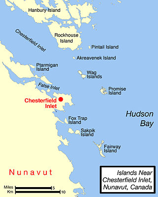
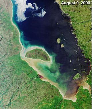
Chesterfield Inlet is an inlet in Kivalliq Region, Nunavut, Canada. It is an arm of northwestern Hudson Bay, and the end point of the Thelon River after its passage through Baker Lake. Cross Bay, a large widening of the inlet, occurs 30 kilometres (19 mi) east of Baker Lake. There are several islands located within the inlet.

Dubawnt Lake is a lake in the Kivalliq Region, Nunavut, Canada. It is 3,630 km2 (1,400 sq mi) in size and has several islands. It is about 320 km (200 mi) north of the Four Corners, about 480 km (300 mi) west of Hudson Bay and about 400 km (250 mi) south of the Arctic Circle. To the northwest is the Thelon Wildlife Sanctuary. Its main inlet and outlet is the north-flowing Dubawnt River which joins the Thelon River at Beverly Lake. The Thelon flows east to Hudson Bay at Chesterfield Inlet. It is on the line of contact between the Sayisi Dene band of Eastern Caribou-Eater Chipewyan people and the Harvaqtuurmiut and Ihalmiut bands of Caribou Inuit. The first recorded European to reach the lake was Samuel Hearne in 1770, but it remained largely unknown to outsiders until it was explored by Joseph Tyrrell in 1893. There are no permanent settlements but there are fly-in fish camps where large lake trout can be caught during the two month ice-free season.
The locality Tavani (TA-vuh-nee) was a mining settlement and trading post in the Kivalliq Region of Nunavut, Canada. Sometimes known as Tavane, it is located on western Hudson Bay's Mistake Bay, 31.3 km (19.4 mi) south of the community of Whale Cove and 97 km (60 mi) east of Kaminak Lake.
Pitsiulartok or Pituilaktok is a small, uninhabited island located at 63°15'N, 90°33'W in Hudson Bay, about 13 km from the community of Chesterfield Inlet, Nunavut, Canada. The narrow island is about 3.5 km in length and barely 1 km wide at its widest point. Traditionally it was a walrus-hunting ground for the local Inuit, and a landmark for southern whalers. It is part of a loose chain of small islands running along the coast, including Sakpik Island and Promise Island.
Promise Island is located near the western shore of Hudson Bay. It is barely a square kilometre in area and rises 300 ft (91 m) in elevation on its northern side. It is located about 9 km (5.6 mi) from the community of Chesterfield Inlet, Nunavut, Canada, and is part of a loose chain of small islands running along the coast, including the Wag Islands and Pitsiulartok.
Harrison Island may refer to: