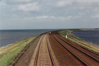
The Trent–Severn Waterway is a 386 kilometres (240 mi)-long canal route connecting Lake Ontario at Trenton to the Georgian Bay, Lake Huron at Port Severn. Its major natural waterways include the Trent River, Otonabee River, the Kawartha lakes, Lake Simcoe, Lake Couchiching and the Severn River. Its scenic, meandering route has been called "one of the finest interconnected systems of navigation in the world".

Lake Simcoe is a lake in southern Ontario, Canada, the fourth-largest lake wholly in the province, after Lake Nipigon, Lac Seul, and Lake Nipissing. At the time of the first European contact in the 17th century the lake was called Ouentironk by the Wyandot (Huron) people. It was also known as Lake Taronto until it was renamed by John Graves Simcoe, the first Lieutenant-Governor of Upper Canada, in memory of his father, Captain John Simcoe, Royal Navy.

The Saugeen River is located in southern Ontario, Canada, The river begins in the Osprey Wetland Conservation Lands and flows generally north-west about 160 kilometres (99 mi) before exiting into Lake Huron. The river is navigable for some distance, and was once an important barge route. Today the river is best known for its fishing and as a canoe route.

The French River is a river in Central Ontario, Canada. It flows 110 kilometres (68 mi) from Lake Nipissing west to Georgian Bay. The river largely follows the boundary between the Parry Sound District and the Sudbury District, and in most contexts is considered the dividing line between Northern Ontario and Southern Ontario. The French River was designated a Canadian Heritage River in 1986.
The Otonabee River is a river in Peterborough County in Central Ontario, Canada. The river flows from Katchewanooka Lake, at the north end of the community of Lakefield, through the city of Peterborough to Rice Lake. It is in the Great Lakes Basin and forms part of the Trent-Severn Waterway.

Curve Lake First Nation 35 is an Ojibwe Indian reserve 14 km north of Peterborough, Ontario. It serves as the landbase for the Curve Lake First Nation. The reserve occupies a peninsula located between Lake Chemong and Buckhorn Lake, surrounded by the township of Selwyn, as well as several neighbouring small islands in Buckhorn Lake.

The Trent River is a river in southeastern Ontario which flows from Rice Lake to empty into the Bay of Quinte on Lake Ontario. This river is part of the Trent-Severn Waterway which leads to Georgian Bay. The river is 90 kilometres (56 mi) long. The Trent drains a large portion of south-central Ontario, including most of the Kawartha Lakes and their supplying watersheds.
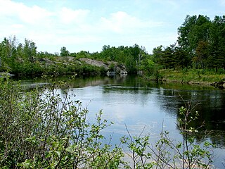
Rice Lake is a lake located in Northumberland and Peterborough counties in south-eastern Ontario. The lake is located south of the city of Peterborough, and the Kawartha Lakes and north of Cobourg. It is part of the Trent-Severn Waterway, which flows into the lake by the Otonabee and out via the Trent. The lake is 28 kilometres (17 mi) long and 5 km wide. Its maximum depth is 10m, with a surface water level at 187 m above sea level, raised to its present height by the Hastings Dam, built in the 19th century as part of the Trent-Severn canal system. Natives called it Pemadashdakota or "lake of the burning plains".

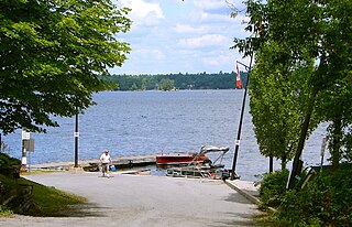
Lake Scugog is an artificially flooded lake in Scugog, Regional Municipality of Durham and the unitary city of Kawartha Lakes in central Ontario, Canada. It lies between the communities of Port Perry and Lindsay. The lake has been raised and lowered several times over its history. Though not technically part of the Kawartha lakes due to its shallow depths, it is often geographically linked to them. Its sole outflow, the Scugog River, connects to Sturgeon Lake. Lake Scugog is in the Great Lakes Basin and forms part of the Trent–Severn Waterway.
The Wanapitei River is a river in Northeastern Ontario, Canada. It is in the Great Lakes Basin and is a right tributary of the French River.

Minaki is an unincorporated area and community in Unorganized Kenora District in northwestern Ontario, Canada. It is located at the point where the Canadian National Railways transcontinental main line crosses the Winnipeg River, between Wade to the west and Ena Lake at the east, and was accessible only by rail until about 1960. It was a fuelling and watering point in the days of steam locomotives; now few trains stop in Minaki, though the thrice-weekly Via Rail transcontinental Canadian passenger trains will stop on request at the Minaki railway station.

Lac Seul is a large, crescent shaped reservoir in Kenora District, northwestern Ontario, Canada. It is approximately 241 km (150 mi) long. It has a maximum (regulated) depth of 47.2 m, with a surface elevation of 357 m above sea level. Its level is raised in the summer and then drawn down in the winter months to reach points of as low as 16 feet below the maximum level. It is the second largest body of water entirely within the province of Ontario. The lake consists of open water bays, narrow channels, and islands. It is a relatively shallow lake with many rock shoals. This provides a good habitat for Walleye aka yellow pickerel and Northern pike as well as Yellow Perch. During the Lac Seul project of 1968-1972 no muskelunge aka masquinonge were noted in the catches of research nets set over those years. Significant numbers of whitefish, tullibee, burbot and cisco were noted as well although they infrequently were noted in the sport fishery. Lac Seul is noted for offering some of the best fishing in Ontario.
King's Highway 7A, commonly referred to as Highway 7A, is a provincially maintained highway in the Canadian province of Ontario that serves as a bypass of Highway 7. The highway begins in the community of Manchester, where Highway 7 is concurrent with Highway 12, and travels east through Port Perry, Nestleton Station, Bethany and Cavan, ending at Highway 115 southwest of Peterborough. From there, Highway 7 can be reached via Highway 115 northbound. Near its midpoint the route is concurrent with Highway 35 for 1.5 kilometres (0.93 mi).
Stony Lake is a lake in Peterborough County in Central Ontario, Canada. There are three interconnected lakes which together are known as Stony or Stoney Lake. Stoney Lake forms the eastern end of the Kawartha lakes region. It is primarily a summer cottage area but there are many permanent residences on the lakes.
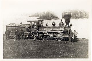
The Cobourg and Peterborough Railway (C&PRy) was one of the first railway lines to be built in Central Ontario, Canada. The line was initially considered in 1831 as a way to bring the products from the burgeoning area around Peterborough to markets on Lake Ontario through the port in the town of Cobourg. A series of problems, including the Upper Canada Rebellion and the Panic of 1837, meant that construction did not begin until 1853, reaching Peterborough in 1854.
Wabatongushi Lake is a lake in Northern Ontario, Canada, fully within the Chapleau Crown Game Preserve. The lake is highly diversified in its topography. The north end of Wabatongushi is shallow with many low, swampy areas. This is perfect habitat for Northern Pike and hungry moose. The south half of the lake is much deeper, with a maximum depth of 175' located right off Loch Island. This set up is ideal for large game fish such as Walleye and Northern Pike. The shoreline on the south end is much higher, with exposed Pre-Cambrian shield plummeting straight into the tea-stained water. Large schools of bait fish congregate off of these shorelines which attract the game fish. Fishing is excellent in these locations on the south end near Loch Island. Wabatongushi is the top lake in a chain that stretches almost 100 miles, eventually draining into lake Superior. It sits on the crest of the northern watershed. Wabatongushi Lake was a traditional transportation route from Hudson Bay to Lake Superior for both First Nations and Voyageurs. Wabatongushi in the Ojibwa language approximately means "White Sand Lake".

Little Lake is a small lake on the Otonabee River in the city of Peterborough, Ontario, Canada. The lake is in the downtown of the city and is used for fishing, swimming, boating, and for various special events. The lake lies on the water route from Lake Ontario to the Kawartha Lakes. The area around the lake was first settled by Europeans around the start of the 19th century. Steam- and water-powered saw mills were built on the lake and on the river upstream to prepare lumber for shipment overseas. Sawdust and other debris from the mills polluted the lake, killed the fish and clogged up the navigable channels. The smell was so noxious it drove residents near the lake to move. These problems were resolved by the end of the century, when the lake became a hub on the new Trent-Severn Waterway from Lake Ontario to Lake Huron. However, industries attracted by cheap hydroelectric power used the lake for disposal of industrial chemicals for many years. The pollutants seems to be mostly contained in the sediment, and the lake is now considered safe for recreational use.