
Aleuts are the Indigenous people of the Aleutian Islands, which are located between the North Pacific Ocean and the Bering Sea. Both the Aleuts and the islands are politically divided between the US state of Alaska and the Russian administrative division of Kamchatka Krai. This group is also known as the Unangax̂ in Unangam Tunuu, the Aleut language. There are 13 federally recognized Aleut tribes in the Aleut Region of Alaska. In 2000, Aleuts in Russia were recognized by government decree as a small-numbered Indigenous people.

Aleutians East Borough is a 2nd class borough in the U.S. state of Alaska. As of the 2020 census the borough's population was 3,420. The borough seat is Sand Point.

Sand Point, also known as Popof Island, is a city in Aleutians East Borough, Alaska, United States. At the 2010 census the population was 976, up from 952 in 2000, but by the 2020 Census this had reduced to 578. It is on northwestern Popof Island, one of the Shumagin Islands, off the Alaska Peninsula. It is the borough seat of Aleutians East Borough, and is near the entrance to the Bering Sea.

Adak, formerly Adak Station, is a city located on Adak Island, in the Aleutians West Census Area, Alaska, United States. At the 2020 census, the population was 171, down from 326 in 2010. It is the westernmost municipality in the United States and the southernmost city in Alaska. The city is the former location of the Naval Air Facility Adak, NAVFAC Adak.

Attu is an island in the Near Islands. It is one of the westernmost points of the U.S. state of Alaska. The island became uninhabited in 2010, making it the largest uninhabited island that is part of the United States politically.
Umnak is one of the Fox Islands of the Aleutian Islands. With 686.01 square miles (1,776.76 km2) of land area, it is the third largest island in the Aleutian archipelago and the 19th largest island in the United States. The island is home to a large volcanic caldera on Mount Okmok and the only field of geysers in Alaska. It is separated from Unalaska Island by Umnak Pass. In 2000, Umnak was permanently inhabited by only 39 people and by 2010, around 18, placing the settlement of Nikolski in difficulty and its school was closed.
The Shumagin Islands are a group of 20 islands in the Aleutians East Borough south of the mainland of Alaska, United States, at 54°54'–55°20' North 159°15'–160°45' West. The largest islands are Unga Island, Popof Island, Korovin Island, and Nagai Island. Other islands include Andronica, Big Koniuji, Little Koniuji, Simeonof, Chernabura, and Bird. The total land area is 1,192.369 km2 and their total population as of the 2020 census was 578 persons, almost entirely in the city of Sand Point, on Popof Island.
Adak Island or Father Island is an island near the western extent of the Andreanof Islands group of the Aleutian Islands in Alaska. Alaska's southernmost city, Adak, is located on the island. The island has a land area of 274.59 square miles (711.18 km2), measuring 33.9 miles (54.5 km) long and 22 miles (35 km) wide, making it the 25th largest island in the United States.
Amaknak Island or Umaknak Island is the most populated island in the Aleutian Islands, an archipelago which is part of the U.S. state of Alaska.

Semisopochnoi Island or Unyak Island is part of the Rat Islands group in the western Aleutian Islands of Alaska. The island is uninhabited and provides an important nesting area for maritime birds. The island is of volcanic origin, containing several volcanoes including Mount Young. It has a land area of 85.558 square miles, measuring 11 miles (18 km) in length and 12 miles (20 km) in width.

Popof Island is an island in the Shumagin Islands south of mainland Alaska. The largest community in the area, Sand Point, is located on the northwest coast. Popof Island is 10 miles (16 km) long, 5 miles (8.0 km) wide and the peak elevation is 1,550 feet. It is located at 55°18′49″N160°22′29″W. It has a land area of 93.651 km2 and a total population of 578 persons at the 2020 census.

Koniuji Island is one of the Andreanof Islands subgroup of the Aleutian Islands of southwestern Alaska, United States. It lies northwest of Atka Island and east of Kasatochi Island. Koniuji Island has a land area of 0.37 sq mi and is uninhabited. The name "Koniuji" is derived from Russian: конюга, romanized: konyuga "auklet", bestowed by Russian sailors in reference to the endemic seabirds. The Aleut name is Tanax̂silĝux̂ "the big made island", in reference to putative recent volcanic activity.
Korovin Island is one of the Shumagin Islands in the Gulf of Alaska south of the Alaska Peninsula in the Aleutians East Borough of Alaska, United States. The island lies northeast of Popof Island and across the Unga Strait from the mainland peninsula. To its southeast are Andronica Island, and further southeast, Nagai Island. Korovin island has a land area of 67.85 km2 and is uninhabited by humans.
Andronica Island is one of the Shumagin Islands in the Gulf of Alaska south of the Alaska Peninsula in Aleutians East Borough of Alaska, United States. It lies east of Popof Island, southeast of Korovin Island, and northwest of Nagai Island. The island has a land area of 14.661 km2 and is uninhabited.

Andrew Gronholdt was a famous Aleut from Sand Point, Alaska, in the Shumagin Islands south of the lower Alaska Peninsula and became famous for rejuvenating the ancient Unangan art of carving hunting hats called chagudax. In January 2012, a book was published posthumously by Gronholdt titled "Chagudax: A Small Window into the Life of An Aleut Bentwood Hat Carver" Gronholdt's woodworking techniques, wood steaming and bending methods, and instructional design methodologies were legendary.

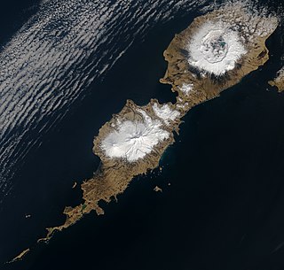
The Aleutian Islands —also called the Aleut Islands, Aleutic Islands, or, before 1867, the Catherine Archipelago—are a chain of 14 main, larger volcanic islands and 55 smaller ones. Most of the Aleutian Islands belong to the U.S. state of Alaska, with the archipelago encompassing the Aleutians West Census Area and the Aleutians East Borough. The Commander Islands, located further to the west, belong to the Russian federal subject of Kamchatka Krai, of the Russian Far East. The islands form part of the Aleutian Arc of the Northern Pacific Ocean, and occupy a land area of 6,821 sq mi (17,666 km2) that extends westward roughly 1,200 mi (1,900 km) from the Alaskan Peninsula mainland, in the direction of the Kamchatka Peninsula; the archipelago acts as a border between the Bering Sea to the north and the Pacific Ocean to the south. Crossing longitude 180°, at which point east and west longitude end, the archipelago contains both the westernmost and easternmost parts of the United States, by longitude. The westernmost U.S. island, in real terms, however, is Attu Island, west of which runs the International Date Line.

An earthquake occurred off the coast of the Alaska Peninsula on July 28, 2021, at 10:15 p.m. local time. The large megathrust earthquake had a moment magnitude of 8.2 according to the United States Geological Survey (USGS). A tsunami warning was issued by the National Oceanic and Atmospheric Administration (NOAA) but later cancelled. The mainshock was followed by a number of aftershocks, including three that were of magnitude 5.9, 6.1 and 6.9 respectively.
Pauloff Harbor Village is a federally recognized Aleut Alaska Native tribal entity.
The Simeonof Wilderness is a wilderness area in Aleutians East Borough, Alaska. The area was designated in 1976 by the United States Congress and is currently managed by the Alaska Maritime National Wildlife Refuge. The Simeonof Wilderness is located on homonymous Simeonof Island in the Shumagin Island group.
Bendel Island is an island located in the Aleutians East Borough, Gulf of Alaska, Southwest of mainland Alaska, United States. The island is part of an island group named the Shumagin Islands, which consist of 20 islands, and lies between the islands of Big Koniuji and Nagai.
 Big Koniuji Island alongside MV Tiglax
 The bird cliffs of Big Koniuji Island
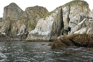
 Boat sailing towards Big Koniuji Island
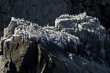 A black-legged Kittiwake colony on the cliffs of the island
 Big Koniuji Island shoreline
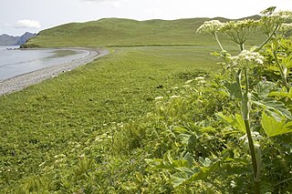


