Rajneeshpuram was a religious intentional community in the northwest United States, located in Wasco County, Oregon. Incorporated as a city between 1981 and 1988, its population consisted entirely of Rajneeshees, followers of the spiritual teacher Rajneesh, later known as Osho.
Norwood Memorial Airport is a public airport 2 mi east of Norwood, in Norfolk County, Massachusetts, United States. It is home to the offices of prominent local business people and several maintenance facilities.
Falmouth Airpark is a public-use airport and residential airpark located four miles (6 km) northeast of the central business district of Falmouth, in Barnstable County, Massachusetts, United States. It is privately owned by Falmouth Airpark Homeowners Association. The airport grew to superscede the Coonamessett Airport which was located in close proximity to the Otis Air National Guard Base and closed in the 1960s.
Palmer Municipal Airport is a public airport located 1 mi (1.6 km) southeast of the central business district of Palmer, a city in Matanuska-Susitna Borough, Alaska, United States. This airport is owned by the City of Palmer.
Sky Ranch Airport, also known as Sky Ranch Estates or Aérodrome de Sky Ranch, is a privately owned, public use airport located two nautical miles (4 km) southwest of the central business district of Sandy Valley, a town in Clark County, Nevada, United States.
Phillips Flying Ranch Airport is a public airport located fifteen miles (24.1 km) southeast of the central business district (CBD) of Rockwall, in Rockwall County, Texas, United States. The airport itself is located in Hunt County.

Baxter County Airport, is a county-owned public-use airport located four nautical miles northwest of the central business district of Mountain Home, a city in Baxter County, Arkansas, United States. It was known as Baxter County Airport until 2005. It changed its name back to Baxter County Airport due to confusion with the close proximity of Ozark, Arkansas and Ozark, Missouri, both of which have airports. The airport used to be served by Lone Star Airlines, which operated services to Dallas-Fort Worth International in the mid-1990s.

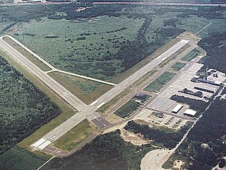
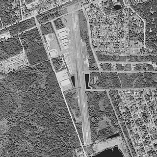
Moton Field Municipal Airport is a public-use airport located three nautical miles north of the central business district of Tuskegee, a city in Macon County, Alabama, United States. The airport is owned by the City of Tuskegee. It is included in the FAA's National Plan of Integrated Airport Systems for 2011–2015, which categorized it as a general aviation facility.
Massey Ranch Airpark is a general aviation airport in Edgewater, Florida, United States. The airport is part of an airport community, with homes located on the airport, and hangars built next to most homes. The airport was opened in 1957 and is open to the public.
Sage Ranch Airport is a private airport located 7 miles southeast of Sisters in Bend, in Deschutes County, Oregon, United States. It is privately owned and operated.

Harris Ranch Airport is an airstrip near Coalinga, California, next to Interstate 5. To the north of the airport is the Harris Ranch Restaurant and Inn. The airport has been open since March 1981.

Big Lake Airport is a state-owned public-use airport located one nautical mile (1.8 km) southeast of the central business district of Big Lake, in the Matanuska-Susitna Borough of the U.S. state of Alaska.
Point Lay LRRS Airport is a public and military use airport owned by the United States Government and located in Point Lay, in the North Slope Borough of the U.S. state of Alaska. It is also known as Point Lay Airport. The acronym LRRS stands for Long Range Radar Site or Long Range Radar Station.
Delta Junction Airport is a public use airport located in and owned by Delta Junction, a city in the Southeast Fairbanks Census Area of the U.S. state of Alaska.
Flying S Ranch Airport is a private airport located approximately 10 miles (16 km) northeast of Caliente, California.
Tanacross Airport is a public use airport located one nautical mile (2 km) south of the central business district of Tanacross, in the Southeast Fairbanks Census Area of the U.S. state of Alaska. It is owned by the Bureau of Land Management.
Yankee Creek Airport, also known as Yankee Creek 2 Airport, is a privately owned public-use airport located one nautical mile south of the central business district of Yankee Creek, in the Yukon-Koyukuk Census Area of the U.S. state of Alaska.
Lazy G Bar Ranch Airport is a privately owned public airport in Decatur, Wise County, Texas, United States, located approximately 5 nautical miles (9.3 km) northeast of the central business district. The airport has no IATA or ICAO designation.
Air Rajneesh was a carrier based at Big Muddy Ranch Airport from 1981 to 1985.
