Related Research Articles

Monterey County, officially the County of Monterey, is a county located on the Pacific coast of the U.S. state of California. As of the 2010 census, the population was 415,057. The county seat and largest city is Salinas.
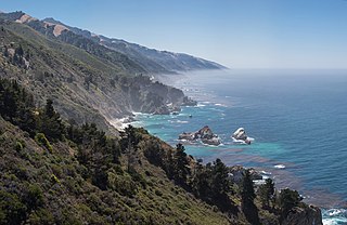
Big Sur is a rugged and mountainous section of the Central Coast of California between Carmel Highlands and San Simeon, where the Santa Lucia Mountains rise abruptly from the Pacific Ocean. It is frequently praised for its dramatic scenery. Big Sur has been called the "longest and most scenic stretch of undeveloped coastline in the contiguous United States," a "national treasure that demands extraordinary procedures to protect it from development" and "one of the most beautiful coastlines anywhere in the world, an isolated stretch of road, mythic in reputation." The stunning views, redwood forests, hiking, beaches, and other recreational opportunities have made Big Sur a popular destination for about 7 million people who live within a day's drive and visitors from across the world. It is among the top 35 tourist destinations world-wide. The region receives about the same number of visitors as Yosemite National Park, but offers extremely limited bus service, few restrooms, and a narrow two-lane highway with few places to park alongside the road. North-bound traffic during the peak summer season and holiday weekends is often backed up for about 20 miles (32 km) from Big Sur Village to Carmel.

The Central Coast is an area of California, United States, roughly spanning the coastal region between Point Mugu and Monterey Bay. It lies northwest of Los Angeles County and south of San Mateo and Santa Clara counties. From south to north, there are six counties that make up the Central Coast: Ventura, Santa Barbara, San Luis Obispo, Monterey, San Benito, and Santa Cruz.

The Monterey Bay National Marine Sanctuary (MBNMS) is a US Federally protected marine area offshore of California's Big Sur and central coast. It is the largest US national marine sanctuary and has a shoreline length of 276 miles (444 km) stretching from just north of the Golden Gate Bridge at San Francisco to Cambria in San Luis Obispo County. Supporting one of the world’s most diverse marine ecosystems, it is home to numerous mammals, seabirds, fishes, invertebrates and plants in a remarkably productive coastal environment. The MBNMS was established in 1992 for the purpose of resource protection, research, education, and public use.
Point Lobos Ranch is an 1,315 acres (532 ha) parcel of land in the northern region of Big Sur, California, United States. It is owned by the California State Park System which since acquiring the land in 2001 has stated that the land is being held for possible use as a state park.

Pfeiffer Big Sur State Park is a state park in Monterey County, California, near the area of Big Sur on the state's Central Coast. It covers approximately 1,006 acres (4.07 km2) of land. The park is centered on the Big Sur River. It has been nicknamed a "mini Yosemite."

The Big Sur River is a 15.7-mile-long (25.3 km) river on the Central Coast of California. The river drains a portion of the Big Sur area, a thinly settled region of the Central California coast where the Santa Lucia Mountains rise abruptly from the Pacific Ocean. The upper river and watershed lies within the Ventana Wilderness and encompasses the headwaters downstream to the area known as the Gorge. The lower river runs through Pfeiffer Big Sur State Park, the Big Sur village, several private camp grounds and Andrew Molera State Park where it flows through a lagoon to the Monterey Bay National Marine Sanctuary in the Pacific Ocean. It flows roughly northwest and empties into the ocean, where there is a natural sandbar that has created a lagoon. Major Tributaries of the river include, in order: Redwood Creek, Lion Creek, Logwood Creek, Terrace Creek, Ventana Creek, Post Creek, Pfeiffer-Redwood Creek, Juan Higuera Creek, and Pheneger Creek.

Garrapata State Park is a state park of California, USA, located on Highway 1 6.7 miles (10.8 km) south of Carmel and 18 miles (29 km) north of Big Sur on the Monterey coast. It is marked only with one sign on the west side of the road. Numbered turnouts mark each parking area. The 2,939-acre (1,189 ha) park was established in 1979.

The Landels-Hill Big Creek Reserve is a constituent of the University of California Natural Reserve System. It is located off State Route 1 in the Big Sur area on California's central coast, fifty miles south of Monterey and adjacent to the Big Creek State Marine Reserve and Big Creek State Marine Conservation Area.
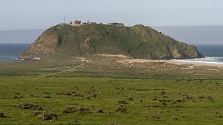
Point Sur State Historic Park is a California State Park on the Big Sur coastline of Monterey County, California, United States, 19 miles (31 km) south of Rio Road in Carmel. The 1889 Point Sur Lighthouse is on the National Register of Historic Places.

Camp Pico Blanco is an inactive camp of about 800 acres (320 ha) in the interior region of Big Sur in Central California. It is operated by the Silicon Valley Monterey Bay Council, of the Boy Scouts of America, a new council formed as a result of a merger between the former Santa Clara County Council and the Monterey Bay Area Council in December 2012. The camp is surrounded by the Los Padres National Forest, the Ventana Wilderness, undeveloped private land owned by Graniterock, and is located astride the pristine Little Sur River. The land was donated to the Boy Scouts by William Randolph Hearst in 1948 and the camp was opened in 1955. The camp was closed following the Soberanes Fire in 2017, and has remained since then after Palo Colorado Road was severely damaged the following winter. Monterey County has been unable to budget the funds required to fix the road.

Rancho San José y Sur Chiquito was a 8,876-acre (35.92 km2) Mexican land grant in present-day Big Sur, in Monterey County, California, given in 1835 to Teodoro Gonzalez and re-granted by Governor Juan Alvarado the same year to Marcelino Escobar. The grant, including Point Lobos, was located south of the Carmel River, extending inland along the coastal mountains, and south along the Pacific coast. It included San Jose Creek, Malpaso Creek, Soberanes Creek, Tres Pinos Creek, Garrapata Creek, and ended on the north side of Palo Colorado Canyon. The map drawn c. 1853 indicated a road or trail was already present along the coast.

The Soberanes Fire was a large wildfire that burned 57 homes and killed a bulldozer operator, and cost about $260 million to suppress, making it at the time the most expensive wildfire to fight in United States history. The Soberanes Fire was the result of an illegal campfire in Garrapata State Park. The fire burned 132,127 acres (53,470 ha) along the Big Sur coast in the Los Padres National Forest, Ventana Wilderness, and adjacent private and public land in Monterey County, California. At the fire's peak, over 5,000 personnel were assigned to the blaze. At the time that it was extinguished, the Soberanes fire ranked 18th on the list of the top 20 largest California wildfires, in terms of acreage burned.
The Big Sur Land Trust is a private 501(c)(3) non-profit located in Monterey, California that has played an instrumental role in preserving land in California's Big Sur and Central Coast regions. The trust was the first to conceive of and use the "conservation buyer" method in 1989 by partnering with government and developers to offer tax benefits as an inducement to sell land at below-market rates. As of 2016, it has protected around 40,000 acres (16,187 ha) through acquisition and resale to government agencies. It has added conservation easements to another 17,000 acres (6,880 ha) and has retained ownership of a number of parcels totaling about 4,500 acres (1,821 ha).

Palo Colorado Canyon is an unincorporated community in the Big Sur region of Monterey County, California. The canyon entrance is located 11.3 miles (18.2 km) south of Carmel Valley River at the former settlement of Notley's Landing, 6.5 miles (10 km) north of Point Sur, and at an elevation of 112 feet.

The policies protecting land used in Big Sur are some of the most restrictive local-use standards in California, and are widely regarded as one of the most restrictive development protections anywhere. The program protects viewsheds from the highway and many vantage points, and severely restricts the density of development. About 60% of the coastal region is owned by governmental or private agencies which do not allow any development. The majority of the interior region is part of the Los Padres National Forest, Ventana Wilderness, Silver Peak Wilderness or Fort Hunter Liggett. The area is protected by the Big Sur Local Coastal Plan, which preserves it as "open space, a small residential community, and agricultural ranching." It's intention is "preserving the environment and visual access to it, the policies of the local coastal plan are to minimize, or limit, all destination activities."

Big Sur Coast Highway is a section of California State Route 1 through the Big Sur region of California that is widely considered to be one of the most scenic driving routes in the United States, if not the world. It was the first California Scenic Highway and the first federal All American Road. It has been compared to the Amalfi Coast of Italy, the rugged scenic north coast of Taiwan, and roadways in the Andes. Condé Nast Traveler named State Route 1 through Big Sur one of the top 10 world-famous streets, comparable to Broadway in New York City and the Champs-Élysées in Paris.

The 2020 coronavirus pandemic in California is part of the ongoing worldwide pandemic of coronavirus disease 2019 (COVID-19). The first case of COVID-19 in the U.S. state of California was confirmed on January 26. A state of emergency has been in place in the state since March 4. A mandatory statewide stay-at-home order was issued on March 19. As of April 27, 2020, the California Department of Public Health says that there have been 45,031 confirmed cases and 1,809 deaths in the state.
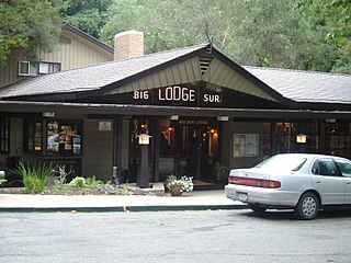
Big Sur is an unincorporated community village in Big Sur, Monterey County, California. It is located along a 1 mile (1.6 km) long stretch of Big Sur Coast Highway in the Big Sur Valley 24 miles (39 km) south of Carmel, California. The village contains the largest collection of shops and visitor services along the entire 71-mile (114 km) segment of California State Route 1 between Malpaso Creek near Carmel Highlands in the north and San Carpóforo Creek near San Simeon in the south. The population is about 1,463. The collection of small roadside businesses and homes is often confused with the larger region, also known as Big Sur. On March 6, 1915, United States Post Office granted the English-speaking resident's request to change the name of their post office from Arbolado to Big Sur. CalTrans also refers to the village as Big Sur.

Bottchers Gap is a day use area, campground, and trail head. It is located 7.6 miles (12.2 km) from the Big Sur Coast Highway at the end of Palo Colorado Road on the northern border of the Los Padres National Forest and Ventana Wilderness. From Bottchers Gap, there is an 3.3 miles (5.3 km) long private access road that leads to Camp Pico Blanco. Beginning at Bottchers Gap, it is a difficult 14.7 miles (23.7 km) hike via the Skinner Ridge and Ventana Double Cone trails to the Ventana Double Cone, making it one of the more distant locations in the wilderness.
References
- ↑ "CPOA Calendar". www.cpoabigsur.org. Retrieved 26 April 2020.
- ↑ "Big Sur Multi-Agency Advisory Council | Monterey County, CA". www.co.monterey.ca.us. Retrieved 26 April 2020.
- ↑ Linville, Kyla (24 August 2019). "Big Sur safety concerns top the list for Big Sur Multi-Agency Advisory council". KSBW. Retrieved 26 April 2020.
- ↑ "Body of Monterey County teen who fell into blowhole found". The Mercury News. 24 January 2019. Retrieved 26 April 2020.
- ↑ "Wave sweeps woman into ocean at Garrapata Beach". Monterey Herald. 18 November 2019. Retrieved 26 April 2020.
| This Monterey County, California-related article is a stub. You can help Wikipedia by expanding it. |