External links
- DC Bike Ride website - Tour organizer
| | This cycling-related article is a stub. You can help Wikipedia by expanding it. |
Bike DC is a bicycle tour of Washington DC, on a closed route cleared of motorized vehicular traffic.
The tour has been staged with both Fall and Spring dates, in 2010 Bike DC was held on May 23. The event consisted of a 23-mile route that started in downtown Washington and ended in Crystal City, Virginia.
The starting point for the tour is at Constitution and Northwest 15th street. The tour runs behind the White House and over the Potomac River into Virginia before terminating in Crystal City where the end of tour festival is held. Riders can return to the starting point via the Mount Vernon Trail from Crystal City.
| | This cycling-related article is a stub. You can help Wikipedia by expanding it. |

The East Coast Greenway is a 3,000-mile (4,800 km) pedestrian and bicycle route between Maine and Florida along the East Coast of the United States. The nonprofit East Coast Greenway Alliance was created in 1991 with the goal to use the entire route with off-road, shared-use paths; as of 2021, over 1,000 mi (1,600 km) of the route (35%) meets these criteria. In 2020, the Greenway received over 50 million visits.

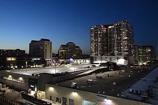
Crystal City is an urban neighborhood in the southeastern corner of Arlington County, Virginia, approximately 5 miles south of Downtown Washington, D.C. Due to its extensive integration of office buildings and residential high-rise buildings using underground corridors, travel between stores, offices, and residences, it is possible to travel much of the neighborhood without going above ground, making at least part of Crystal City an underground city.
London to Brighton refers to a variety of races, tours, charity bicycle rides and rallies that take place between London and Brighton in the United Kingdom.
Pentagon City is an unincorporated neighborhood located in the southeast portion of Arlington County, Virginia. It is located near The Pentagon and Arlington National Cemetery.

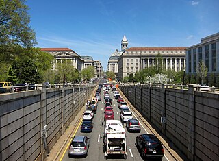
Interstate 395 (I-395) in Virginia and Washington, D.C., is a 13.79-mile-long (22.19 km) spur route of I-95 that begins at an interchange with I-95 in Springfield and ends at an interchange with US Route 50 (US 50) in Northwest Washington, D.C. It passes underneath the National Mall near the US Capitol and ends at a junction with US 50 at New York Avenue, roughly one mile (1.6 km) north of the 3rd Street Tunnel. Despite its proximity to I-395 in Maryland, the route is unrelated and unconnected.
The Rock Creek and Potomac Parkway, informally called the Rock Creek Parkway, is a parkway maintained by the National Park Service as part of Rock Creek Park in Washington, D.C. It runs next to the Potomac River and Rock Creek in a generally north–south direction, carrying four lanes of traffic from the Lincoln Memorial and Arlington Memorial Bridge north to a junction with Beach Drive near Connecticut Avenue at Calvert Street, N.W., just south of the National Zoological Park.

Virginia State Route 110 (SR 110) is a primary state highway in Arlington, Virginia. Known as the Richmond Highway, the state highway runs 2.41 miles (3.88 km) from U.S. Route 1 (US 1) and Interstate 395 (I-395) in Crystal City north to I-66 in the Rosslyn neighborhood. SR 110 is a four- to six-lane freeway that parallels the Potomac River, providing a connection between several of Arlington's urban villages and major landmarks, including the Pentagon, which is the headquarters of the United States Department of Defense, and the grounds of Arlington National Cemetery. The highway also provides access to SR 27, an east–west freeway between the Pentagon and the cemetery, and the George Washington Parkway that parallels the Potomac River. SR 110 is a part of the National Highway System for its entire length.

State Route 120 is a primary state highway in the U.S. state of Virginia. Known as Glebe Road, the state highway runs 9.10 miles (14.65 km) from U.S. Route 1 (US 1) in Crystal City north to SR 123 at the Chain Bridge. SR 120 is a partial circumferential highway in Arlington County that connects the southeastern and northwestern corners of the county with several urban villages along its crescent-shaped path, including Ballston. The state highway also connects all of the major highways in Virginia that radiate from Washington, including Interstate 395, I-66, US 50, and US 29. SR 120 is a part of the National Highway System for its entire length.

The Mount Vernon Trail (MVT) is an 18-mile (29 km) long shared use path that travels along the George Washington Memorial Parkway in Northern Virginia between Rosslyn and George Washington's home at Mount Vernon. The trail connects the easternmost portions of Arlington County, the City of Alexandria, and Fairfax County, and travels mostly on dedicated trail with a small portion on city streets. As part of U.S. Bike Route 1, the Potomac Heritage Trail and the East Coast Greenway, the MVT opened in April 1972 as a gravel path and was subsequently expanded and paved.

Metrobus is a bus service operated by the Washington Metropolitan Area Transit Authority (WMATA). Its fleet consists of 1,595 buses covering an area of 1,500 square miles (3,900 km2) in Washington, D.C., Maryland, and Virginia. There are 269 bus routes serving 11,129 stops, including 2,554 bus shelters. In 2023, the system had a ridership of 103,438,600, or about 364,300 per weekday as of the first quarter of 2024.

Bike the Drive or Fifth Third Bike the Drive is a recreational, non-competitive bicycle ride held each year in Chicago. Lake Shore Drive is cleared of motor vehicle traffic and opened exclusively to bicyclists for several hours beginning at dawn. The event benefits bicycling advocacy work in the region by the Active Transportation Alliance, formerly known as the Chicagoland Bicycle Federation. Since 2004, Bike the Drive has usually been held on the Sunday of Memorial Day weekend, though it was cancelled in 2020, and in 2021 and 2022 was held in early September. In 2006, an estimated 20,000 riders participated in the event. The event is sponsored by Fifth Third Bank and branded as Fifth Third Bike the Drive; it was previously sponsored by MB Financial Bank from 2010 to 2018 and prior to 2010, was sponsored by Bank of America.
Washington, D.C. has a number of different modes of transportation available for use. Commuters have a major influence on travel patterns, with only 28% of people employed in Washington, D.C. commuting from within the city, whereas 33.5% commute from the nearby Maryland suburbs, 22.7% from Northern Virginia, and the rest from Washington, D.C.'s outlying suburbs.
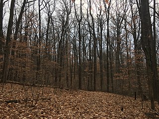
Fort Dupont Park is a 376-acre (1.52 km2) wooded park under the management of the National Park Service located in Washington, DC. The name of the park comes from the old Civil War earthwork fort that lies within the park. The fort was one of several designed to defend Washington from a Confederate attack during the Civil War. There are few remains of the actual fortifications.
Bike Philly was a bicycle tour of Philadelphia, Pennsylvania, on a closed route cleared of motorized vehicular traffic. The tour is sponsored by the Bicycle Coalition of Greater Philadelphia, and it occurs on the second Sunday of September. The inaugural event for Bike Philly was held on September 9, 2007, and consisted of two 10 mile loops, a Center City route, and a Fairmount Park route. The ride attracted 2,500 riders

Arlington Ridge is a neighborhood in Arlington County, Virginia. It is bordered on the north by The Pentagon, on the west by the Army Navy Country Club, and on the south the Alexandria. The main thoroughfare is the eponymous Arlington Ridge Road, a mansion-lined boulevard that, due to its high elevation, offers views of Washington, D.C., and the surrounding areas.

Metroway is a bus rapid transit (BRT) line operated by the Washington Metropolitan Area Transit Authority (WMATA) as part of their Metrobus system. It consists of a single line operating in Arlington and Alexandria, Virginia. It opened on August 24, 2014. It was the first bus rapid transit line to open in Virginia and in the Washington metropolitan area.
Capital Bikeshare is a bicycle-sharing system, which serves Washington, D.C., and certain counties of the larger metropolitan area. As of January 2023, it had 700+ stations and more than 5,400 bicycles. The member jurisdictions own most of the equipment and have sourced operations to contractor Motivate International. Opened in September 2010, the system was the largest bike sharing service in the United States until New York City's Citi Bike began operations in May 2013.
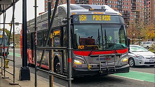
The Columbia Pike–Pentagon City Line, designated as Routes 16G & 16H, were daily bus routes that was operated by the Washington Metropolitan Area Transit Authority between the neighborhoods of Arlington Mill (16G) or Skyline City (16H) and Pentagon City station of the Yellow and Blue lines of the Washington Metro. This line is part of the Pike Ride service, which runs through Columbia Pike. This line provides service through the neighborhoods of Fairfax County and Arlington County to Pentagon City. Unlike the Columbia Pike Line, the Columbia Pike–Pentagon City Line does not serve Columbia Pike past the Arlington County line.
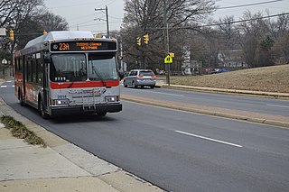
The McLean–Crystal City Line, designated Routes 23A, 23B & 23T, is a daily bus route operated by the Washington Metropolitan Area Transit Authority between Tysons Corner Center and Ballston–MU station of the Orange and Silver lines of the Washington Metro and Shirlington Transit Center & Crystal City station of the Yellow and Blue lines of the Washington Metro.
The Alexandria–Pentagon Line, designated as Routes 10A, 10E & 10N, is a daily bus route operated by the Washington Metropolitan Area Transit Authority between Huntington station of the Yellow Line of the Washington Metro (10A), Hunting Point (10E), or Ronald Reagan Washington National Airport station of the Yellow and Blue lines of the Washington Metro and Pentagon station of the Yellow and Blue lines of the Washington Metro. This line provides service within the neighborhoods in Fairfax County, Alexandria, and Arlington County. Alongside the neighborhoods, it also brings service through the marketplace, businesses, and offices within the counties.