
Kotagiri is a hill station and a taluk in the Nilgiris district of the Indian state, Tamil Nadu. The Nilgiri hills have been the traditional home of the "Kota" tribes. The name 'Kota-giri' itself means 'mountains of the kotas'. Kotagiri was known in the past as 'Kota-keri' or 'Kota-gherry', the 'street of Kotas'. The town has developed around numerous knolls and valleys. It is one of the largest hill stations in the Nilgiri Mountains. Located at an average elevation of 1,950 m (6,400 ft), Kotagiri is quietly tucked away in the Nilgiris and used to be one of the summer resorts of Madras Presidency. The town was discovered in the year 1819 by John Sullivan when he came to a village called Dhimbatty to the north of Kotagiri. Kotagiri enjoys the third coldest climate next to Ooty and Kodaikanal in South India.

Kozhikode International Airport, also known as Calicut International Airport, is an international airport serving the city of Kozhikode and Malappuram in the state of Kerala, India. It also serves other cities and districts of the Malabar region, Wayanad and Palakkad. It is situated 28 km (17 mi) away from Kozhikode. The airport opened on 13 April 1988, and serves as an operating base for Air India Express and operates Hajj Pilgrimage services to Medina and Jeddah from Kerala. It is tied with Hyderabad in terms of international traffic. It received the international airport status on 2 February 2006. It is one of the few airports in the country with a tabletop runway.

The Mettur Dam is one of the largest dams in India and also the largest in Tamil Nadu, located across the river Kaveri where it enters the plains. Built in 1934, it took nine years to complete. Maximum height and width of the dam are 214 and 171 feet, respectively. The dam receives inflows from its own catchment area, Kabini Dam and Krishna Raja Sagara Dams located in Karnataka. There is a park at the base of the dam. It provides irrigation and drinking water facilities for more than 12 districts of Tamil Nadu and hence is revered as the life and livelihood-giving asset of Tamil Nadu.
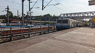
The Hyderabad Multi-Modal Transport System, commonly abbreviated as MMTS, is a suburban rail system in Hyderabad, India. A joint venture of the Government of Telangana and the South Central Railway, it is operated by the latter. The 90-kilometre (56 mi) system caters to the city of Hyderabad and the neighbouring suburban areas connecting Hyderabad, Secunderabad, Falaknuma, Lingampally, Medchal and Umdanagar with a total of 133 MMTS services. Currently 86 MMTS services are being operated due to the effect of COVID-19.

Gulbarga University or, University of Gulbarga, is a public university located in Kalaburagi, Karnataka, India. The university is recognized by University Grants Commission and accredited by National Assessment and Accreditation Council (NAAC). In 2016, Gulbarga university was awarded 'B' grade by NAAC.
Thirunindravur is a locality in the western part of Chennai, Tamil Nadu. It lies within the Chennai Metropolitan Area, around 30 kilometers from the city center at Parry's Corner. The neighbourhood is served by Thirunindravur railway station of Chennai suburban railway. Thiruninravur lake provides the neighbourhood with water. It serves as the connecting hub between Chennai and Tirupati.
The Thiruvananthapuram - Shoranur canal is a historic canal in India, from Trivandrum to Shoranur. It was one of the most arterial transportation mode in erstwhile Travancore princely state. Most of the trade, commerce and freight traffic in Travancore used to happen through this canal. The canal used to pass through rice bowl of the state, Kuttanad, centre of Coir trade i.e. Alappuzha, centre of Cashew business, Kollam, Changanassery market, strategic Thevally, Kayamkulam, Varkala etc. and used to connect Thiruvithamkoor with Cochin State and Malabar.
Kundara is a satellite town in Kerala and is part of the Kollam Metropolitan Area, India. Kundara is situated at the eastern end of Kollam city. Kundara is significant for its historic involvement in the Indian independence movement.
Pattom is a dense commercial region of Thiruvananthapuram city in Kerala, India. It is located approximately 4 kilometres north of centre of Thampanoor. Pattom is largely a residential area, also housing few important administration offices of Kerala State and a few shopping complexes. It has offices of Kerala Public Service Commission, Kerala State Planning Board, Life Insurance Corporation of India, Thiruvananthapuram Divisional Office, LIC Housing Finance Limited, State Resource Centre, District Panjayat Headquarters, Fire and Rescue Department Headquarters, Kerala Co-operative Milk Marketing Federation (Milma), Employees Provident Fund Regional Office and Kerala State Electricity Board. The Traffic Police and Telecommunication department, and the Kerala Science, Technology and Environment Head Office are also located in Pattom.

Vellayani Lake, or Vellayani Kayal, is the second largest freshwater lake in the state of Kerala and is situated in Thiruvananthapuram, Kerala, India. In ancient times, boats laden with goods used to navigate the Vellayani backwaters up to Chala.

The Thiruvananthapuram–Kasaragod Hill Highway or State Highway 59 (SH-59) is a proposed state highway in Kerala. Upon completion, it will be the longest highway in Kerala, extending from Nandarapadavu in Kasaragod district to Parassala in Thiruvananthapuram district, at a length of 1332.16 km. The highway will pass through 13 of the 14 districts, the exception being Alappuzha as that district is not part of the hilly ranges of Kerala.
Vyttila, IPA:[ʋɐjt̺ːilɐ], is a ward in the city of Kochi, Kerala. It is a prominent area located in southern Kochi. The Vyttila junction is the busiest as well as the largest intersection in Kerala. This node intersects the main north–south artery of the state of Kerala, namely, the Kochi Bypass, with three city roads of Kochi viz, the S. A. Road, the Vyttila-Petta Road, and the Thammanam Road.

The Janasena Party is an Indian political party active in the states of Andhra Pradesh and Telangana. Founded by Pawan Kalyan on 14 March 2014, it is currently the second largest party in the Andhra Pradesh Legislative Assembly and a partner in the ruling coalition. Pawan Kalyan, the party leader, has been serving as the Deputy Chief Minister of Andhra Pradesh since June 2024. Janasena advocates for a centrist approach with a focus on humanism. The party's election symbol is a glass tumbler.
Queerala, a registered community-based Organisation (CBO) for Malayali LGBTIQ people, gives adequate support to Malayali persons who belong to the sexual and gender minorities. Queerala originally started in May 2013 as a secret Facebook page where closeted LGBTQAI+ community members met online. Since its start of operations, Queerala has been an active platform for the rights of the LGBTIQ+ community in Kerala and India and focuses on various awareness campaigns on Sexual Orientation, Gender Identity/Expression, and Sex Characteristics (SOGIESC). Queerala's representatives have been marking its presence, in areas of literature, art, cultural spaces, and academic discourses as well as conducting case studies on issues pertaining to sexual orientation and gender identity. They also focus on sensitization on SOGIESC inclusive healthcare services, educational curriculum, workplace policies and local self-governance.

NTR bus station is a bus station in Guntur and owned by Andhra Pradesh State Road Transport Corporation. The bus station serves both the city and district services in Andhra Pradesh as well buses from neighboring states of Karnataka, Tamil Nadu and Telangana.
The Children's Arena is a children's world in Visakhapatnam, India and the only one of its type in Andhra Pradesh. It is located in Siripuram which is also known as the "heart of the city" It has a seating capacity of 1000. The Auditorium is used to conduct various functions, such as birthday parties, music shows, school celebrations and cultural activities related to children. The multipurpose theatre is designed to showcase movies predominantly in English, Telugu and Hindi.
Gollapalli Reservoir is an irrigation project located in Anantapur district of Andhra Pradesh, India. It receives water from Handri-Neeva canal which draws water from Srisailam reservoir. It is located at Gollapalli village in Penukonda Constituency.
Waterways have always been an important mode of transport in Kerala. The total length of navigable route in Kerala was 1,900 kilometres and the navigable rivers constitute about 54 per cent of the waterways. The 41 West-flowing rivers together with the backwaters are an integrated part of the inland navigation system in Kerala. In Kerala water transportation through these channels are mainly small distant passenger services, informal country boats, freight transportation to PSU's such as Fertilisers and Chemicals Travancore, Kochi etc.

