Related Research Articles
The Metropolitan Borough of Wigan is a metropolitan borough of Greater Manchester, England. It is named after its largest town, Wigan but covers a far larger area which includes the towns of Atherton, Ashton-in-Makerfield, Golborne, Hindley, Ince-in-Makerfield, Leigh and Tyldesley. The borough also covers the villages and suburbs of Abram, Aspull, Astley, Bryn, Hindley Green, Lowton, Mosley Common, Orrell, Pemberton, Shevington, Standish, Winstanley and Worsley Mesnes. The borough is also the second-most populous district in Greater Manchester.

Orrell is a suburb of Wigan in the Metropolitan Borough of Wigan, Greater Manchester, England. The population of the ward had fallen at the 2011 Census to 11,513. The area lies 3 miles (4.8 km) to the west of Wigan town centre. The area is contiguous with Pemberton.
Billinge is a village within the Metropolitan Borough of St Helens, Merseyside, England. It forms the larger part of the civil parish of Billinge Chapel End.

Standish-with-Langtree was, and to a limited extent remains, a local government district centred on Standish, Lancashire, in North West England. Historically it was an ancient township in the hundred of West Derby and county of Lancashire. This unit was abolished in 1974 following the Local Government Act 1972, the same act which established Greater Manchester.
Turton Urban District was, from 1873 to 1974, a local government district centred on the historical area of Turton in the administrative county of Lancashire, England.
Wigan Rural District was an administrative district in Lancashire, England from 1894 to 1974. The rural district comprised an area to the north, but did not include the town of Wigan.
Ince was a parliamentary constituency in England which elected one Member of Parliament (MP) to the House of Commons of the Parliament of the United Kingdom. It comprised the town of Ince-in-Makerfield and other towns south of Wigan.

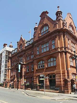
The Municipal Borough of Leigh was, from 1899 to 1974, a local government district of the administrative county of Lancashire, England, consisting of the townships of Pennington, Westleigh, Bedford and part of the township of Atherton and named after the ancient ecclesiastical parish. The area contained the market town of Leigh that served as its administrative centre until its dissolution in 1974. The borough council built Leigh Town Hall which was completed in 1907.
Bradshaw is a village of the unparished area of South Turton in the Metropolitan Borough of Bolton in Greater Manchester, England. It gives its name to the larger Bradshaw electoral ward, which includes Harwood. within the Historic County of Lancashire, Bradshaw lies on the southern edge of the West Pennine Moors.
Higher End or Billinge Higher End is an area of the Metropolitan Borough of Wigan, Greater Manchester, England.

Longshaw is a small residential and agricultural area within Billinge Higher End at the western boundary of the Metropolitan Borough of Wigan, in Greater Manchester, England. It is situated at the northern foot of Billinge Hill on the B5206 road. Historically, Longshaw was part of Lancashire.

The Municipal Borough of Farnworth was a local government district centred on the town of Farnworth in the administrative county of Lancashire, England. A local board of health had been established for Farnworth in 1863, which was reconstituted as an urban district in 1899, before being granted a charter of incorporation to become a municipal borough in 1939. Following abolition of the local authority in 1974, Farnworth became an unparished area of the Metropolitan Borough of Bolton in Greater Manchester.

Tyldesley cum Shakerley Urban District and its successor Tyldesley Urban District was, from 1894 to 1974, a local government district in Lancashire, England.

Atherton was, from 1863 to 1974, a local government district in Lancashire, England.
Blackrod was, from 1872 to 1974, a local government district centred on the village of Blackrod in the administrative county of Lancashire, England.
Horwich was, from 1872 to 1974, a local government district centred on the town of Horwich in the administrative county of Lancashire, England.
Kearsley was, from 1865 to 1974, a local government district centred on the town of Kearsley in the administrative county of Lancashire, England.
Little Lever was, from 1872 to 1974, a local government district centred on the large village of Little Lever in the administrative county of Lancashire, England.

Westhoughton was, from 1872 to 1974, a local government district centred on the town of Westhoughton in the administrative county of Lancashire, England.
Blackrod Town Council is a local authority with limited powers and covers the town and civil parish of Blackrod in the Metropolitan Borough of Bolton, Greater Manchester, England. It is made up of nine town Councillors representing three electoral Wards.
References
- ↑ "Billinge: Adoption of the Local Government Act for the District of Billinge". Wigan Observer. 26 October 1894. p. 8. Retrieved 18 February 2022.
- ↑ "Local Government Act, 1858: Notice of Adoption of Act in the District of Billinge, Lancashire". London Gazette (23929): 6347. 17 December 1872. Retrieved 18 February 2022.
- ↑ "Billinge and Winstanley Urban District". A Vision of Britain through Time. GB Historical GIS / University of Portsmouth. Retrieved 18 February 2022.
- ↑ Great Britain Historical GIS Project (2004). "Billinge and Winstanley UD through time. Census tables with data for the Local Government District". A vision of Britain through time. University of Portsmouth. Archived from the original on 1 October 2007.
- ↑ "Greater Manchester Gazetteer". Greater Manchester County Record Office. Places names - B. Archived from the original on 18 July 2011.