
The foreign relations of the Libyan Arab Jamahiriya (1969–2011) underwent much fluctuation and change. They were marked by severe tension with the West and by other national policies in the Middle East and Africa, including the Libyan government's financial and military support for numerous paramilitary and rebel groups.

The 1986 United States bombing of Libya, code-named Operation El Dorado Canyon, comprised air strikes by the United States against Libya on Tuesday, April 15, 1986. The attack was carried out by the U.S. Air Force, U.S. Navy and U.S. Marine Corps via air strikes, in retaliation for the 1986 West Berlin discotheque bombing. There were 40 reported Libyan casualties, and one U.S. plane was shot down. One of the claimed Libyan deaths was of a baby girl, reported to be Muammar Gaddafi's daughter, Hana Gaddafi. However, there were doubts as to whether she was really killed, or whether she really even existed. Military intelligence reports cited Gaddafi fleeing his location and leaving his family members behind when inbound missiles were determined to be targeting his location.
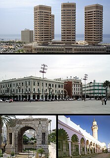
Tripoli is the capital city and the largest city of Libya, with a population of about 1.158 million people in 2018. It is located in the northwest of Libya on the edge of the desert, on a point of rocky land projecting into the Mediterranean Sea and forming a bay. It includes the port of Tripoli and the country's largest commercial and manufacturing centre. It is also the site of the University of Tripoli. The vast Bab al-Azizia barracks, which includes the former family estate of Muammar Gaddafi, is also located in the city. Colonel Gaddafi largely ruled the country, from his residence in this barracks.

Muammar Mohammed Abu Minyar Gaddafi, commonly known as Colonel Gaddafi, was a Libyan revolutionary, politician, and political theorist. He governed Libya as Revolutionary Chairman of the Libyan Arab Republic from 1969 to 1977, and then as the "Brotherly Leader" of the Great Socialist People's Libyan Arab Jamahiriya from 1977 to 2011. He was initially ideologically committed to Arab nationalism and Arab socialism but later ruled according to his own Third International Theory.

N’Djamena is the capital and largest city of Chad. A port on the Chari River, near the confluence with the Logone River, it directly faces the Cameroonian town of Kousséri, to which the city is connected by a bridge. It is also a special statute region, divided into 10 districts or arrondissements. It is a regional market for livestock, salt, dates, and grains. Meat, fish and cotton processing are the chief industries, and the city continues to serve as the center of economic activity in Chad.

Benghazi is the second-most populous city in Libya and the largest in Cyrenaica.

UTA Flight 772 was a scheduled international passenger flight of the French airline Union de Transports Aériens operating from Brazzaville in the People's Republic of the Congo, via N'Djamena in Chad, to Charles de Gaulle Airport in Paris that crashed into the Ténéré desert, near Bilma, Niger after an in-flight explosion in September 1989 with 170 people on board. It is the deadliest aviation incident to occur in Niger and the fourth-deadliest involving a DC-10, after Air New Zealand Flight 901, American Airlines Flight 191, and Turkish Airlines Flight 981.

On 5 April 1986, three people were killed and 229 injured when La Belle discothèque was bombed in the Friedenau district of West Berlin. The entertainment venue was commonly frequented by United States soldiers, and two of the dead and 79 of the injured were Americans.

The Egyptian Air Force (EAF), is the aviation branch of the Egyptian Armed Forces, is responsible for all airborne defence missions and operates all military aircraft, including those used in support of the Egyptian Army, Egyptian Navy and the Egyptian Air Defense Forces, created as a separate command in the 1970s, coordinates with the Air Force to integrate air and ground-based air defense operations. The EAF is headed by an Air Marshal. Currently, the commander of the Egyptian Air Force is Air Marshal Mohamed Abbas. The force's motto is 'Higher and higher for the sake of glory'.

Zawiya, officially Zawia, is one of the districts of Libya. It is located in the north western part of the country, in what had been the historical region of Tripolitania. Its capital is also named Zawia. Since the 2007 reorganization of Libyan districts, the former district of Sabratha Wa Surman has been part of Zawiya District. In the north, Zawiya has a shoreline bordering the Mediterranean Sea, while it borders Tripoli in east, Jafara in southeast, Jabal al Gharbi in south, Nuqat al Khams in the west.

The murder of Yvonne Fletcher, a Metropolitan Police officer, occurred on 17 April 1984, when she was fatally wounded by a shot fired from the Libyan embassy on St James's Square, London, by an unknown gunman. Fletcher had been deployed to monitor a demonstration against the Libyan leader Muammar Gaddafi, and died shortly afterwards. Her death resulted in an eleven-day siege of the embassy, at the end of which those inside were expelled from the country and the United Kingdom severed diplomatic relations with Libya.

The Sukhoi Su-17 is a Soviet variable-sweep wing fighter-bomber developed from the Sukhoi Su-7. It enjoyed a long career in Soviet, later Russian, service and was widely exported to Eastern Bloc, Arab air forces, Angola and Peru as the Su-20 and Su-22. It is the first variable-sweep wing of Russian/Soviet origin.

Muammar Gaddafi became the de facto leader of Libya on 1 September 1969 after leading a group of young Libyan military officers against King Idris I in a bloodless coup d'état. After the king had fled the country, the Libyan Revolutionary Command Council (RCC) headed by Gaddafi abolished the monarchy and the old constitution and established the Libyan Arab Republic, with the motto "freedom, socialism and unity".
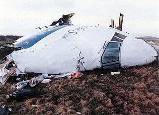
Pan Am Flight 103 was a regularly scheduled Pan Am transatlantic flight from Frankfurt to Detroit via London and New York. On 21 December 1988, N739PA, the aircraft operating the transatlantic leg of the route was destroyed by a bomb, killing all 243 passengers and 16 crew – a disaster known as the Lockerbie bombing. Large sections of the aircraft crashed onto residential areas of Lockerbie, Scotland, killing 11 people on the ground. With a total of 270 people killed, it was the deadliest terror attack in the history of Great Britain.
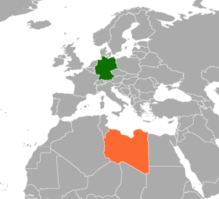
Germany–Libya relations are bilateral relations between the Central European state of Germany and the North African state of Libya. Germany is represented in Libya with an embassy in Tripoli and a diplomatic office in Benghazi, while Libya has an embassy in Berlin. The relationship between these countries was tense in the late 1980s following a bombing incident, but improved since with increasingly close co-operation especially on economic matters. However, during the 2011 Libyan civil war, Germany sided politically with the National Transitional Council, which it recognized as Libya's legitimate government after severing ties with Muammar Gaddafi's regime.
Sūq al-Jum'a (also Suk el Giuma, Soug al Juma’aa, or Sugh el Giumaa, literally "Friday Market", is a district of Tripoli, Libya, located 5 km east of Tripoli and now incorporated into the greater metropolitan area of the capital. The population in was estimated to be roughly 40,000 residents. A majority of these residents, 60%, are considered to be “native Libyan, from Tripoli and Arab", however, this population is mixed with those of Berber and Turkish descent as well, and dominantly Amazigh. Many families in this area reject the idea of tribal society and consider themselves to be 100% from Tripoli/Libya and Arab, but they likely descend from, and are part of, the Magarha tribe, which is among the largest in Libya. The Magarha tribe originates in the Fezzan province of Libya. Soug al Juma'aa was among the first within Tripoli proper who fought and rebelled against Gaddafi in the 17 February 2011 revolution, which led to Gaddafi’s ultimate downfall, despite the Magarha tribe's strong ties and links to Gaddafi. Along with Tajura, residents of Soug al Jum’aa are considered to be the original inhabitants of Tripoli.
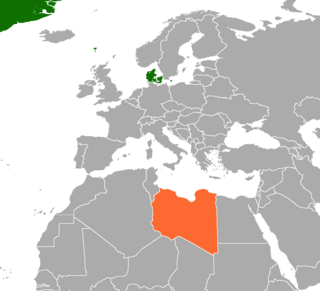
Denmark–Libya relations refers to the current and historical relations between Denmark and Libya. Bilateral relations are tense because of the Jyllands-Posten Muhammad cartoons controversy and the 2011 military intervention in Libya. Denmark is represented in Libya, through its embassy in Cairo, Egypt. Danish Foreign Minister Villy Søvndal visited Libya in February 2012, for the opening of the new representative office in Tripoli.
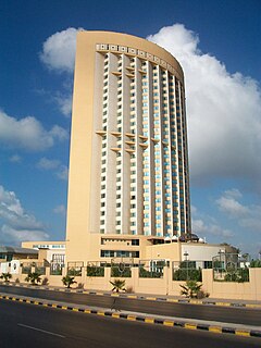
In January 2015, the Corinthia Hotel in Tripoli was attacked by men affiliated with the Islamic State of Iraq and the Levant (ISIL). The hotel was popular with foreign officials and government workers; it had previously housed the Libyan Prime Minister.
The February 2015 Egyptian airstrikes in Libya against Islamic State of Iraq and the Levant (ISIL) positions in Libya took place on February 16, 2015, and were triggered by a video released by ISIL in Libya a day earlier, depicting the beheading of 21 Coptic Christians from Egypt. Within hours, the Egyptian Air Force responded with airstrikes against ISIL training camps and weapons stockpiles in retaliation for the killings. Warplanes acting under orders from the Libyan government also struck targets in Derna, reportedly in coordination with Egypt.

The Battle of Sirte (2016) refers to the battle that started in the spring of 2016, in the region of Sirte, Libya, between the Islamic State of Iraq and the Levant (ISIL) and the forces of the Government of National Accord (GNA) backed by United States of America. ISIL forces had captured Sirte one year earlier, during the previous battle.

