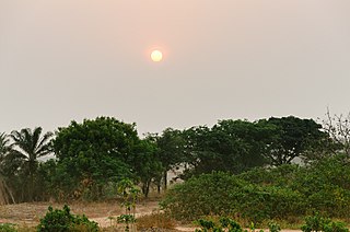
Niger or the Niger, officially the Republic of the Niger, is a landlocked country in West Africa named after the Niger River. Niger is bordered by Libya to the northeast, Chad to the east, Nigeria to the south, Benin to the southwest, Mali to the northwest, Burkina Faso to the southwest, and Algeria to the northwest. Niger covers a land area of almost 1,270,000 km2 (490,000 sq mi), making it the largest country in West Africa. Over 80% of its land area lies in the Sahara Desert. The country's predominantly Muslim population of about 22 million live mostly in clusters in the far south and west of the country. The capital and largest city is Niamey, located in Niger's southwest corner.
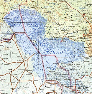
The Niger River is the principal river of West Africa, extending about 4,180 km (2,600 mi). Its drainage basin is 2,117,700 km2 (817,600 sq mi) in area. Its source is in the Guinea Highlands in southeastern Guinea. It runs in a crescent through Mali, Niger, on the border with Benin and then through Nigeria, discharging through a massive delta, known as the Niger Delta, into the Gulf of Guinea in the Atlantic Ocean. The Niger is the third-longest river in Africa, exceeded only by the Nile and the Congo River. Its main tributary is the Benue River.

The Fula,Fulani, or Fulɓe people are one of the largest ethnic groups in the Sahel and West Africa, widely dispersed across the region. Inhabiting many countries, they live mainly in West Africa and northern parts of Central Africa but also in South Sudan, Sudan, and regions near the Red Sea coast. The approximate number of Fula people is unknown due to clashing definitions regarding Fula ethnicity; various estimates put the figure between 35 and 45 million worldwide.
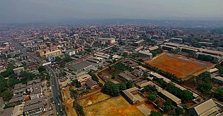
Onitsha is a city located on the eastern bank of the Niger River, in Nigeria's Anambra State. A metropolitan city, Onitsha is known for its river port and as an economic hub for commerce, industry, and education. It hosts the Onitsha Main Market, the largest market in Africa in terms of geographical size and volume of goods.

Northern Nigeria was a British protectorate which lasted from 1900 until 1914 and covered the northern part of what is now Nigeria.

Birni-N'Konni is a town in the Tahoua Region of Niger, lying immediately north of the border of Nigeria and west of seasonal Maggia River. It is an important market town and transport hub and as of the 2012 census had a population of 63,169. The town is the historic centre of the small pre-colonial Hausa state of Konni. The name comes from the Hausa for "Walled Town of Konni", and many Hausa towns designate the old citadel neighbourhood the "Birni".
The Niger Delta is the delta of the Niger River sitting directly on the Gulf of Guinea on the Atlantic Ocean in Nigeria. It is typically considered to be located within nine coastal southern Nigerian states, which include: all six states from the South South geopolitical zone, one state (Ondo) from South West geopolitical zone and two states from South East geopolitical zone. Of all the states that the region covers, only Cross River is not an oil-producing state.

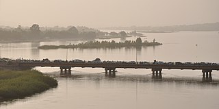
Jebba is a Nupe, city situated in Mokwa local Government Area of Niger State, Nigeria. It has views of the River Niger and as of 2007 had an estimated population of 22,411. The town has the benefit of being split into North and South Jebba. South Jebba falling in Kwara State and North in Niger State. It is home to the largest paper mill in West Africa, as well as being the home of one of Nigeria's three hydro-electric dams. Powering the whole of Nigeria, every day. It has also a monument to Mungo Park, in remembrance of the shipwreck which took place there, while he tried to trace the source of the Niger. More recently it has taken in 16 new residents in the form of volunteers from Nigeria and the UK. Jebba's main quality is its Islamic culture.
Igboland (Standard Igbo: Àlà Ị̀gbò, also known as Southeastern Nigeria, is the homeland of the Igbo people. It is a cultural and common linguistic region in southern Nigeria. Geographically, it is divided by the lower Niger River into two sections: an eastern and a western one. Its population is characterised by the diverse Igbo culture and the speakers of equally diverse Igbo languages.

There are over 525 native languages spoken in Nigeria. The official language of Nigeria is English, the former language of colonial British Nigeria. As reported in 2003, Nigerian English and Nigerian Pidgin were spoken as a second language by 60 million people in Nigeria. Communication in the English language is much more popular in the country's urban communities than it is in the rural areas, due to globalization.
The key environmental issues in the Niger Delta of Nigeria relate to its petroleum and industry.
Nsugbe is a town in Anambra East Local Government Area, Anambra State, Nigeria.

The Islamic State in West Africa or the Islamic State's West Africa Province, formerly known as Jamā'at Ahl as-Sunnah lid-Da'wah wa'l-Jihād and commonly known as Boko Haram, is a jihadist terrorist organization based in northeastern Nigeria, also active in Chad, Niger and northern Cameroon.
Dandi is a Local Government Area (LGA) in Kebbi State, Nigeria, sharing a boundary with the Republic of Niger. Its headquarters are in the town of Kamba. Dandi shares a southern border with Bunza LGA.
Lere is a Local Government Area and town in southern Kaduna State of Nigeria. Lere town is located geographically at the latitude 10 degrees 39 North and longitude 8 degrees 57 East. It is the headquarters of the Lere Emirate. The town and its environs has an estimated population of about 93,290 (2016). Lere Local Government has an area of 2,634 km2 and a population of 339,740 at the 2006 census. Its headquarters are in the town of Saminaka. The postal code of the area is 811.
Timeline of the Boko Haram insurgency is the chronology of the Boko Haram insurgency, an ongoing armed conflict between Nigerian Islamist group Boko Haram and the Nigerian government. Boko Haram have carried out many attacks against the military, police and civilians since 2009 – mostly in Nigeria, but also in Cameroon, Chad and Niger.

The Dambazawa are a Fulani clan residing mainly in Kano State, Nigeria. They were among the key promoters, planners and executors of the Fulani Jihad in Kano, which took place between 1804 and 1807 under the leadership of Shehu Usuman dan Fodiyo. The clan was said to be the top financier of the jihad because it was said to be extremely wealthy at the time of the jihad. Other Fulani Clans that participated in the Jihad included: the Jobawa, the Yolawa, the Sullubawa, the Danejawa and others, as well as a contingent of the native Hausa people lead by Malam Usuman bahaushe. Together they formed a formidable force and toppled the 158 year Kutumbawa dynasty led by its last ruler Muhammad Alwali dan Yaji dan Dadi bakutumbe who ruled between 1781 and 1806.
The Chad Basin campaign of 2018–2020 was a series of battles and offensives in the southern Chad Basin, particularly northeastern Nigeria, which took place amid the ongoing Boko Haram insurgency. The Chad Basin witnessed an upsurge of insurgent activity from early November 2018, as rebels belonging to the Islamic State's West Africa Province (ISWAP) and Boko Haram launched offensives and several raids to regain military strength and seize territory in a renewed attempt to establish an Islamic state in the region. These attacks, especially those by ISWAP, met with considerable success and resulted in the displacement of hundreds of thousands of civilians. The member states of the Multinational Joint Task Force (MJTF), namely Nigeria, Niger, Chad, and Cameroon responded to the increased insurgent activity with counter-offensives. These operations repulsed the rebels in many areas, but failed to fully contain the insurgency.

The Second Niger bridge is a Nigerian Federal Government project that is 1.6 km (0.99 mi) long and furnished with other ancillary infrastructure including a 10.3 km (6.4 mi) highway, Owerri interchange and a toll station, expected to be completed in the year 2022. The bridge was initiated under the administration of Goodluck Jonathan and is being sustained by President Muhammadu Buhari.
Atak Nfang is a district and a village community in Zangon Kataf Local Government Area, southern Kaduna state in the Middle Belt region of Nigeria. The postal code for the area is 802142.