
The Humber is a large tidal estuary on the east coast of Northern England. It is formed at Trent Falls, Faxfleet, by the confluence of the tidal rivers Ouse and Trent. From there to the North Sea, it forms part of the boundary between the East Riding of Yorkshire on the north bank and North Lincolnshire on the south bank. Also known as the River Humber, it is tidal its entire length.
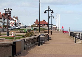
Hornsea is a seaside town and civil parish in the East Riding of Yorkshire, England. The settlement dates to at least the early medieval period. The town was expanded in the Victorian era with the coming of the Hull and Hornsea Railway in 1864. In the First World War, the mere was briefly the site of RNAS Hornsea Mere, a seaplane base. During the Second World War, the town and beach were heavily fortified against invasion.

Portland Harbour is beside the Isle of Portland, Dorset, on the south coast of England. Construction of the harbour began in 1849; when completed in 1872, its 520-hectare (1,300-acre) surface area made it the largest human-made harbour in the world, and it remains one of the largest in the world today. It is naturally sheltered by Portland to the south, Chesil Beach to the west and mainland Dorset to the north. It consists of four breakwaters: two southern and two northern. These have a total length of 4.57 km (2.84 mi) and enclose approximately 1,000 ha of water.
The Admiralty Pier Turret, or Dover Turret, is an enclosed armoured turret built in 1882 on the western breakwater of Dover Harbour in southeast England. It contains two Fraser RML 16 inch 80 ton guns, the biggest installed in the United Kingdom. Declared obsolete in 1902, it is currently part of the port and inaccessible, though the guns remain in place.

Dymchurch Grand Redoubt is a fortification at Palmarsh on the coast of Kent in England, built during the Napoleonic War as part of a large defensive scheme to protect the country from an expected French invasion.
Grain Fort is a former artillery fort located just east of the village of Grain, Kent. It was constructed in the 1860s to defend the confluence of the Rivers Medway and Thames during a period of tension with France. The fort's location enabled its guns to support the nearby Grain Tower and Garrison Point Fort at Sheerness on the other side of the Medway. It was repeatedly altered and its guns upgraded at various points in its history, before being decommissioned in 1956 when the UK abolished its coastal defence programme. It was subsequently demolished. The remnants of the fort are still visible and have been incorporated into a coastal park.

Garrison Point Fort is a former artillery fort situated at the end of the Garrison Point peninsula at Sheerness on the Isle of Sheppey in Kent. Built in the 1860s in response to concerns about a possible French invasion, it was the last in a series of artillery batteries that had existed on the site since the mid-16th century. The fort's position enabled it to guard the strategic point where the River Medway meets the Thames. It is a rare example of a two-tiered casemated fort – one of only two of that era in the country – with a design that is otherwise similar to that of several of the other forts along the lower Thames. It remained operational until 1956 and is now used by the Sheerness Docks as a port installation.

The Verne High Angle Battery is a former 19th-century gun battery on the Isle of Portland in Dorset, England. Situated close to the Verne Citadel, the battery is Grade II Listed, and forms part of the citadel's scheduled monument status. The battery has become a tourist attraction, while the battery's tunnels are often referred to by their local name 'Ghost Tunnels'.

Stallingborough is a village and civil parish in North East Lincolnshire, England. The population of the civil parish at the 2011 census was 1,234.
Yaverland Battery is a battery on the Isle of Wight, United Kingdom. It was constructed between 1861 and 1864.
Balaclava Bay is a bay situated on the edge of Portland Harbour, where the breakwater meets the island, at the northern end of the Isle of Portland, Dorset, in southern England. The bay is overlooked by the Victorian East Weare Battery, built in the 1860s to protect the harbour. The nearest road within the dockyard of Portland Port is named Balaclava Road.

Nothe Gardens is a public garden, located in Weymouth, Dorset, England. Positioned on the Nothe Peninsula overlooking both Weymouth and Portland harbours, the informal gardens are often acclaimed to be the most beautiful the borough has to offer.

Durdle Pier is a disused 17th-century stone shipping quay, located on the Isle of Portland, Dorset, England; part of the Jurassic Coast. It is found close by Yeolands Quarry, on the east side of the island within the area of East Weares and Penn's Weare.

Verne Heavy Anti-Aircraft Battery is a World War II anti-aircraft battery on the Isle of Portland, Dorset, England. It is located on private property in the north-east area of the island, south of the Verne Citadel. The battery became a scheduled monument in March 2019.

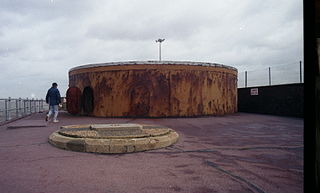
Inner Pierhead Fort is a 19th-century fort built to defend Portland Harbour at the Isle of Portland, Dorset, England. It is positioned on the end of the inner breakwater, which abuts from the former dockyard of HMNB Portland. The fort was constructed between 1859-1862, and is 100 ft in diameter. The inner breakwater, including the fort, became Grade II Listed in 1978.
Grain Wing Battery is a former gun battery located just east of the village of Grain, Kent at the confluence of the Rivers Thames and Medway. It supported two existing and adjacent artillery batteries at Grain Fort and Dummy Battery, overlapping its arc of fire with Grain Tower just offshore and with Garrison Point Fort on the Isle of Sheppey across the other side of the Medway. The battery consisted of an earthwork with several gun emplacements. It was only in use as a battery for a few years after its completion in 1895, though its interior continued to be occupied by Army buildings. It was abandoned in 1956 and its remains were demolished and infilled a few years later. The site is now part of a coastal park owned by the local council.

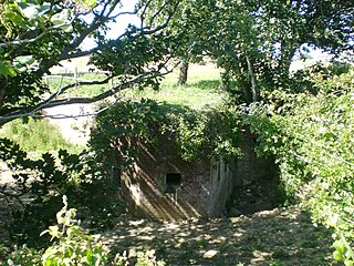
Dummy Battery, originally known as Grain Battery, is a disused fortified gun battery located about 1 kilometre (0.62 mi) south of the village of Grain, Kent at the confluence of the Rivers Thames and Medway. Completed in 1865, it supported two nearby coast artillery batteries at Grain Fort and Grain Wing Battery, a short distance to the north. The battery's arc of fire overlapped with Grain Tower just offshore and with Garrison Point Fort on the Isle of Sheppey across the other side of the Medway. It consisted of an earthwork with a concrete core supporting several gun emplacements with magazines below. It appears to have gone out of service as a battery by the time of the First World War, though it briefly took on a role in anti-aircraft defence. It was subsequently abandoned and was severely damaged by demolitions and the removal of its earthworks, leaving only the substantial remains of its concrete core standing today.

Wollongong Harbour Precinct is a heritage-listed shipping harbour at Cliff Road and Endeavour Drive, in Wollongong, New South Wales, Australia. It was built in 1837. The historic precinct includes Belmore Basin, Government Dam, Government Basin, Stockade Point, Flagstaff Hill, Signal Hill, Brighton Beach, Boat Harbour and Fortress Hill. It was added to the New South Wales State Heritage Register on 5 May 2010.
Brownhill Battery is a former gun battery at Staddon Heights, Plymouth, Devon. It was one of a number of Plymouth fortifications to be recommended by the Royal Commission on the Defence of the United Kingdom in 1859. Construction began in 1861, at the same time as Staddon Fort and other defensive works at Staddon Heights. The battery was completed by 1868, but was left unarmed.