Related Research Articles

Bentley is a town in central Alberta, Canada within Lacombe County. It is located on Highway 12, approximately 28 km (17 mi) northwest of Red Deer.

The County of Stettler No. 6 is a municipal district in central Alberta, Canada.

Division No. 9 is a census division in Alberta, Canada. It is located in the southwest corner of central Alberta and its largest urban community is the Town of Rocky Mountain House. The boundaries of the division are coextensive with the outer boundaries of Clearwater County.
Glenbow is a locality in southern Alberta, in Rocky View County located northwest of the City of Calgary and east of the Town of Cochrane on Highway 1A. It is now part of the Glenbow Ranch Provincial Park. The Glenbow area is immediately west of Rocky View County's Bearspaw area.

Lac Ste. Anne County is a municipal district in central Alberta, Canada.
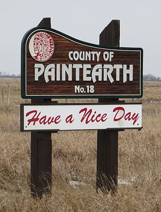
The County of Paintearth No. 18 is a municipal district in east central Alberta, Canada. Located in Census Division No. 7, its municipal office is located southeast of the Town of Castor near the intersection of Highway 12 and Highway 36.
De Winton is a hamlet in southern Alberta, Canada within the Foothills County. It is located just south of the City of Calgary and west of Highway 2A.

Cherhill is a hamlet in Alberta, Canada within Lac Ste. Anne County. It is located along Highway 43, approximately 35 kilometres (22 mi) east of Mayerthorpe and 82 kilometres (51 mi) northwest of Edmonton.
Alhambra is a hamlet in Alberta, Canada within Clearwater County. It is located close to the David Thompson Highway, east of Rocky Mountain House.

Buck Lake 133C is an Indian reserve of the Paul First Nation in Alberta, located within the County of Wetaskiwin No. 10. It is 87 kilometers west of Wetaskiwin.
Child Lake 164A is an Indian reserve of the Beaver First Nation in Alberta, located within Mackenzie County. It is 32 kilometers northwest of Fort Vermilion. The reserve takes its name from a nearby lake where a child once drowned.
Belvedere is a locality in Alberta, Canada.
Glenford is a locality in Alberta, Canada.
Decrene is a locality in Alberta, Canada. It is located northwest of the Hamlet of Smith and is sparsely inhabited.
Garfield is a locality in Alberta, Canada.
Burtonsville is a locality in Alberta, Canada.
Highvale is a locality in Alberta, Canada.

Alexis 133 is an Indian reserve of the Alexis Nakota Sioux Nation in Alberta, located within Lac Ste. Anne County. It is 70 kilometres northwest of Edmonton. In the 2016 Canadian Census, it recorded a population of 755 living in 173 of its 209 total private dwellings.
Geikie is a locality in Alberta, Canada.
References
- ↑ "Bingley". Geographical Names Data Base . Natural Resources Canada.
- ↑ Place-names of Alberta. Ottawa: Geographic Board of Canada. 1928. p. 20. Archived from the original on December 30, 2017. Retrieved January 14, 2017.
52°27′28″N114°47′36″W / 52.4579°N 114.7934°W
| | This Central Alberta location article is a stub. You can help Wikipedia by expanding it. |