Ladybower Reservoir is a large Y-shaped reservoir, the lowest of three in the Upper Derwent Valley in Derbyshire, England. The River Ashop flows into the reservoir from the west; the River Derwent flows south, initially through Howden Reservoir, then Derwent Reservoir, and finally through Ladybower Reservoir.

The Feather River is the principal tributary of the Sacramento River, in the Sacramento Valley of Northern California. The river's main stem is about 73 miles (117 km) long. Its length to its most distant headwater tributary is just over 210 miles (340 km). The main stem Feather River begins in Lake Oroville, where its four long tributary forks join together—the South Fork, Middle Fork, North Fork, and West Branch Feather Rivers. These and other tributaries drain part of the northern Sierra Nevada, and the extreme southern Cascades, as well as a small portion of the Sacramento Valley. The total drainage basin is about 6,200 square miles (16,000 km2), with approximately 3,604 square miles (9,330 km2) above Lake Oroville.
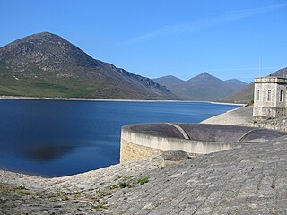
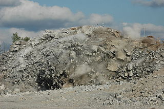
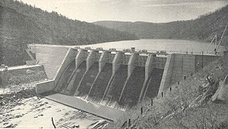
The Silent Valley Reservoir is a reservoir located in the Mourne Mountains near Kilkeel, County Down in Northern Ireland. It supplies most of the water for County Down, surrounding counties and most of Belfast. It is owned and maintained by Northern Ireland Water Limited. The reservoir was built between 1923 and 1933 by a workforce of over one thousand men, nine of whom died.
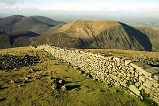
The Mourne Wall is a wall constructed to enclose a catchment area in the Mourne Mountains, Northern Ireland. It was built between 1904 and 1922 by the Belfast City and District Water Commissioners to enclose a reservoir.

The Colorado-Big Thompson Project is a federal water diversion project in Colorado designed to collect West Slope mountain water from the headwaters of the Colorado River and divert it to Colorado's Front Range and plains. In Colorado, approximately 80% of the state's precipitation falls on the West Slope, in the Rocky Mountains, while around 80% of the state's growing population lives along the East Slope, between the cities of Fort Collins and Pueblo.

Arenig Fawr is a mountain in Snowdonia, North Wales, close to Llyn Celyn reservoir, alongside the A4212 between Trawsfynydd and Bala.

Dillon Reservoir, sometimes referred to as Lake Dillon, is a large fresh water reservoir located in Summit County, Colorado, south of I-70 and bordered by the towns of Frisco, Silverthorne, and Dillon. It is a reservoir for the city of Denver, and its waters are under the control of Denver Water. Popular ski areas are close to the reservoir, including Copper Mountain, Keystone, Arapahoe Basin, and Breckenridge.

Slieve Binnian is one of the Mourne Mountains in County Down, Northern Ireland, 9km north of Kilkeel. It is the third highest mountain in Northern Ireland at 747 metres (2,451 ft). The summit is broad and flat with rocky tors at the north and south ends, with the Back Castles, impressive towers of granite, in between. To the south-west is Wee Binnian (460m). It lies to the east of the Silent Valley Reservoir and the west of the Annalong Valley. The Mourne Wall also crosses over Slieve Binnian.
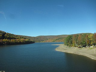
The Pepacton Reservoir, also known as the Downsville Reservoir, is a reservoir in Delaware County, New York on the East Branch of the Delaware River in the Catskill Mountains of New York. Part of the New York City water supply system, it was formed by the construction of Downsville Dam, and empounds over one-quarter of the East Branch's flow.

The Catskill Aqueduct, part of the New York City water supply system, brings water from the Catskill Mountains to Yonkers where it connects to other parts of the system.

Cherry Creek is a large, swift-flowing stream in the Sierra Nevada mountain range, and is the largest tributary of the Tuolumne River. The creek is 40 miles (64 km) long measured to its farthest headwaters; the main stem itself is 26 miles (42 km) long, draining a watershed of 234 square miles (610 km2) in the Stanislaus National Forest. Part of the drainage also extends into the northwest corner of Yosemite National Park.
The Ware River is a 35.4-mile-long (57.0 km) river in central Massachusetts. It has two forks, the longer of which begins near Hubbardston, Massachusetts. The Ware River flows southwest through the middle of the state, joins the Quaboag River at Three Rivers, Massachusetts, to form the Chicopee River on its way to the Connecticut River.
The East Delaware Tunnel is a 25-mile (40 km) aqueduct in the New York City water supply system. Located in the Catskill Mountains of New York State, it was constructed within a six-year period between 1949 and 1955 to transport drinking water from the Pepacton Reservoir to the Rondout Reservoir. The tunnel begins near the former site of Pepacton, New York, and ends near the former site of Eureka, New York, passing through Delaware County, Sullivan County and Ulster County. The tunnel has a maximum transmission capacity of 500 million US gallons (1,900,000 m3) per day and was constructed at a width of 11 feet (3.4 m).
Events during the year 1952 in Northern Ireland.
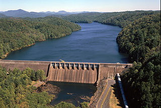
Apalachia Dam is a hydroelectric dam on the Hiwassee River in Cherokee County, in the U.S. state of North Carolina. The dam is the lowermost of three dams on the river owned and operated by the Tennessee Valley Authority, which built the dam in the early 1940s to provide emergency power for aluminum production during World War II. While the dam is in North Carolina, an 8.3-mile (13.4 km) underground conduit carries water from the dam's reservoir to the powerhouse located 12 miles (19 km) downstream across the state line in Polk County, Tennessee. The dam and associated infrastructure were listed on the National Register of Historic Places in 2017.
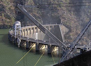
Calderwood Dam is a hydroelectric dam located along the Little Tennessee River in Blount and Monroe counties, in the U. S. state of Tennessee. Completed in 1930, the dam is owned and maintained by Tapoco, a subsidiary of the Aluminum Company of America (Alcoa), although the Tennessee Valley Authority controls the dam's reservoir levels from Fontana Dam further upstream. Calderwood Dam is named for Alcoa engineer Isaac Glidden Calderwood (1871–1941), who supervised much of the company's early Little Tennessee River operations.
The Mottram Tunnel is a tunnel carrying drinking water by gravity from Arnfield Reservoir, Tintwistle, Derbyshire in the valley of the River Etherow, to Godley, Greater Manchester in the valley of the River Tame. It was essential to the construction of the Longdendale Chain of reservoirs constructed by John Frederick Bateman. The tunnel was built between August 1848 and October 1850, and the Godley service reservoir was built to receive and filter the water. That was finished in 1851.
Ocoee Dam No. 3 is a hydroelectric dam on the Ocoee River in Polk County, in the U.S. state of Tennessee. It is one of four dams on the Toccoa/Ocoee River owned and operated by the Tennessee Valley Authority, which built the dam in the early 1940s to meet emergency demands for electricity during World War II. The dam impounds the 360-acre (150 ha) Ocoee No. 3 Reservoir, which stretches 11 miles (18 km) upriver to the Tennessee-Georgia state line. Ocoee No. 3's powerhouse is actually located several miles downstream from the dam, and is fed by a 2.5-mile (4.0 km) conduit that carries water to it from the reservoir.

Spring Creek Debris Dam is an earthfill dam on Spring Creek, a tributary of the Sacramento River, in Shasta County in the U.S. state of California. Completed in 1963, the dam, maintained by the U.S. Bureau of Reclamation, serves primarily to collect severe acid mine drainage stemming from the Iron Mountain Mine. The dam forms the Spring Creek Reservoir, less than 1 mile (1.6 km) long. Spring Creek and South Fork Spring Creek flow into the reservoir from a 16-square-mile (41 km2) watershed. The dam is directly upstream from the city of Keswick, California and the Keswick Reservoir. The operation is part of the Trinity River Division of the Central Valley Project.

Ben Crom Reservoir is a reservoir located in the Mourne Mountains near Kilkeel, County Down, Northern Ireland. Along with Silent Valley Reservoir, which is situated further down the Kilkeel River valley, it supplies water for County Down, surrounding counties and most of Belfast. It was constructed between 1953 and 1957, as the final part of the Mourne scheme to provide water to Belfast which started with the passing of the Belfast Water Act in 1893.