Related Research Articles

Highwood is an unincorporated community and census-designated place (CDP) in Chouteau County, Montana, United States. The population was 176 at the 2010 census.
Dupuyer Creek is a tributary of Birch Creek in northwestern Montana in the United States.
Route 99 is a short highway in southern Missouri. Its northern terminus is at U.S. Route 60 just north of Birch Tree in Shannon County; its southern terminus is at U.S. Route 160 south of Thomasville in Oregon County 18.3 miles (29.5 km) to the SSE. It crosses the Eleven Point River at Thomasville. Just south of Thomasville Route 99 provides access to the west end of the Eleven Point Wild and Scenic River portion of the Mark Twain National Forest.
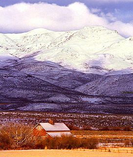
The Highwood Mountains are an island range which cover approximately 4,659 km² of the Central Montana Alkalic Province in north central Montana in the U.S. They are in Chouteau, Judith Basin and Cascade counties and lie east of Great Falls and Benton Lake National Wildlife Refuge, at the northern end of the Lewis and Clark National Forest. The mountains were included in Highwood Mountains National Forest until 1908, when the unit became part of Lewis and Clark National Forest.
The Gap Mountains are a mountain range in eastern Nye County, Nevada. Gap Mountain along with Fox Mountain 7.5 miles (12.1 km) to the south and the hills between overlook the White River valley to the west. Gap Mountain lies just 1.5 mi (2.4 km) southwest of the southern end of the Egan Range of adjacent Lincoln County and appears to be an extension of that range. Fox Mountain lies about 5 miles west of the south end of the Schell Creek Range and 7 mi (11 km) northeast of the north end of the Seaman Range.The Grant Range and small Golden Gate Range lie to the west across the White River Valley.
Parachute Creek is a 14.7-mile-long (23.7 km) tributary of the Colorado River in Garfield County, Colorado. The confluence with the Colorado is just south of the community of Parachute and east of U.S. Route 6.
The Owyhee Mountains are a mountain range in Owyhee County, Idaho and Malheur County, Oregon.
The Little Snowy Mountains are a small mountain range in central Montana about 25 miles (40 km) southeast of Lewistown. The range lies mostly in Fergus County, but the southern part of the range extends into Golden Valley and Musselshell counties.
Big Piney Creek is a river located in Ozark National Forest in the state of Arkansas. It is a tributary of the Arkansas River and therefore part of the Mississippi River watershed. Managed by the United States Forest Service, it flows for 70.8 miles (113.9 km) through Pope, Johnson and Newton counties. The headwaters of the creek are in a rugged, remote area just east of Arkansas Route 21 south of the community of Fallsville and the mouth of the creek empties into Lake Dardanelle on the Arkansas River.
Birch Creek is an unincorporated community in Menominee County, in the U.S. state of Michigan.
Yellow Creek is a stream in Chariton County in the U.S. state of Missouri. It is a tributary of the Grand River.
Shoal Creek is a stream in southeastern Crawford County in the U.S. state of Missouri. It is a tributary of Huzzah Creek.
Birch Creek is a stream in Franklin County in the U.S. state of Missouri. It is a tributary of the Bourbeuse River.
Cat Creek is a stream in Grundy and Harrison counties in the U.S. state of Missouri. It is a tributary of the Thompson River.
Tavern Creek is a stream in Miller and Pulaski counties in the U.S. state of Missouri. It is a tributary of the Osage River. The stream headwaters are at 37°54′42″N92°22′19″W and the confluence with the Osage is at 38°19′04″N92°17′24″W.
Bull Creek is a stream in Christian and Taney counties in the Ozarks of southern Missouri.

Spring Creek is a stream in Douglas and Howell counties in the Ozarks of southern Missouri.
Long Creek is a stream in western Boone and eastern Carroll counties of Northwest Arkansas. The stream is a tributary of the Table Rock Lake section of White River.
Core Creek is a small stream in Laclede County, Missouri. It is a tributary of the Osage Fork Gasconade River.
Rosebud Creek is a generally north flowing stream in Rosebud and Big Horn counties of Montana. It is a tributary to the Yellowstone River.
References
- 1 2 U.S. Geological Survey Geographic Names Information System: Birch Creek (Chouteau County, Montana)
- ↑ Council Island, Montana, 7.5 Minute Topographic Quadrangle, USGS, 1954 (1985 rev.)
- ↑ Warrick, Montana, 7.5 Minute Topographic Quadrangle, USGS, 1984