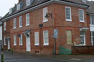
The Red House is a Queen Anne style house built around 1710 opposite the intersection of Norfolk Road and High Street in Buntingford, Hertfordshire, England. It was inhabited by artist and stage designer Claud Lovat Fraser, who designed the Buntingford war memorial and other aspects of the town. The building was used by estate agency Churchills, but currently appears unoccupied. It is a Grade II Listed Building.

Wakehurst, previously known as Wakehurst Place, is a house and botanic gardens in West Sussex, England, owned by the National Trust but used and managed by the Royal Botanic Gardens, Kew. It is near Ardingly, West Sussex in the High Weald, and comprises a late 16th-century mansion and a mainly 20th-century garden, and Kew’s Millennium Seed Bank, in a modern building. Visitors are able to see the gardens, the mansion, and also visit the seed bank. The garden today covers some 2 square kilometres and includes walled and water gardens, woodland and wetland conservation areas.
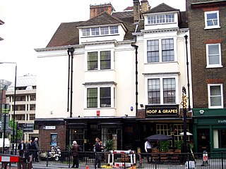
The Hoop and Grapes is a Grade II* listed public house at Aldgate High Street, Aldgate, London.

Paxtons Head is a Grade II listed public house at 153 Knightsbridge, London.

Homer Row is a street in the Marylebone district of the City of Westminster, London, that runs form Old Marylebone Road in the north to the junction of Crawford Place and Crawford Street in the south.

The Hare and Hounds is a public house at 104 Sopwell Lane in St Albans, Hertfordshire, England. The timber framed building has a plastered exterior. It is listed Grade II with Historic England and is dated "seventeenth century or earlier".

The Fleur de Lys was a public house in French Row, St Albans, Hertfordshire, England. The building has a C18th brick facade, but it dates from the Middle Ages and is listed grade II with Historic England. The building was refurbished and renamed "The Snug" in 2007, to become part of the Snug bar chain.

The Lion is a former public house on the corner of Barnet Road and Southgate Road in Potters Bar, Hertfordshire, England, and a grade II listed building with Historic England. It became Potty Pancakes some time after 2008.

The White Horse, now known as The Cask and Stillage, is a public house in High Street, Potters Bar, England, and a grade II listed building with Historic England.

Ladbrooke School is a former school in High Street, Potters Bar, England, and a grade II listed building with Historic England.

The Green Man is a disused public house in High Street, Potters Bar, England, and a grade II listed building with Historic England.

Wyllyotts Manor is a public house and restaurant in Potters Bar, England, and a grade II listed building with Historic England. It consists of a late 16th-century barn, possibly built for Robert Taylor between 1594 and 1603, and a house that dates from around 1800.
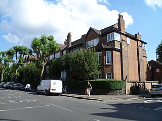
The Gables is a block of flats in Fortis Green, on the edge of Muswell Hill, London, and a grade II listed building with Historic England. The building was constructed in 1907 to a design by Herbert and William Collins in the Arts and Crafts and Jugendstil style.

The George is a Grade II listed public house in Twickenham, in the London Borough of Richmond upon Thames. It is in three adjoining buildings at 32–36 King Street, parts of which date from the late 17th century.

The Clachan is a public house at 33 Kingly Street, London W1.

The Fox is a pub at 39 Church Street, Twickenham, London TW1.

The Crown is a pub at 174 Richmond Road, Twickenham, London TW1.

The Jolly Coopers is a pub at 16 High Street, Hampton, London TW12.

Grosvenor Gardens is the name given to two triangular parks in Belgravia, London, faced on their western and eastern sides by streets of the same name. Both roads run roughly north to south from Hobart Place and Grosvenor Place to Buckingham Palace Road.

Stanhope House is a grade II listed building at 46 and 47 Park Lane, Mayfair, London W1.


