Related Research Articles

India is situated north of the equator between 8°4' north to 37°6' north latitude and 68°7' east to 97°25' east longitude. It is the seventh-largest country in the world, with a total area of 3,287,263 square kilometres (1,269,219 sq mi). India measures 3,214 km (1,997 mi) from north to south and 2,933 km (1,822 mi) from east to west. It has a land frontier of 15,200 km (9,445 mi) and a coastline of 7,516.6 km (4,671 mi).

Madhya Pradesh is a state in central India. Its capital is Bhopal, and the largest city is Indore, with Gwalior, Jabalpur, Ujjain, Dewas, Sagar, Satna, and Rewa being the other major cities. Madhya Pradesh is the second largest Indian state by area and the fifth largest state by population with over 72 million residents. It borders the states of Uttar Pradesh to the northeast, Chhattisgarh to the east, Maharashtra to the south, Gujarat to the west, and Rajasthan to the northwest.

The large Deccan Plateau in southern India is located between the Western Ghats and the Eastern Ghats, and is loosely defined as the peninsular region between these ranges that is south of the Narmada River. To the north, it is bounded by the Satpura and Vindhya Ranges.
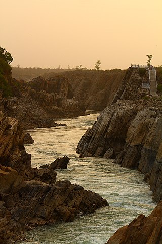
The Narmada River, previously also known as Narbada or anglicised as Nerbudda, is the 5th longest river in India and overall the longest west-flowing river in the country. It is also the largest flowing river in the state of Madhya Pradesh. This river flows through the states of Madhya Pradesh and Gujarat in India. It is also known as the "Lifeline of Madhya Pradesh and Gujarat" due to its huge contribution to the two states in many ways. The Narmada River rises from the Amarkantak Plateau in Anuppur district in Madhya Pradesh. It forms the traditional boundary between North and South India and flows westwards for 1,312 km (815.2 mi) before draining through the Gulf of Khambhat into the Arabian Sea, 30 km (18.6 mi) west of Bharuch city of Gujarat.

The common hill myna, sometimes spelled "mynah" and formerly simply known as the hill myna or myna bird, is the myna most commonly sighted in aviculture, where it is often simply referred to by the latter two names. It is a member of the starling family (Sturnidae), resident in hill regions of South Asia and Southeast Asia. The Sri Lanka hill myna, a former subspecies of G. religiosa, is now generally accepted as a separate species G. ptilogenys. The Enggano hill myna and Nias hill myna are also widely accepted as specifically distinct, and many authors favor treating the southern hill myna from the Nilgiris and elsewhere in the Western Ghats of India as a separate species.

The Satpura Range is a range of hills in central India. The range rises in eastern Gujarat running east through the border of Maharashtra and Madhya Pradesh and ends in Chhattisgarh. The range parallels the Vindhya Range to the north, and these two east–west ranges divide Indian Subcontinent into the Indo-Gangetic plain of northern India and the Deccan Plateau of the south. The Narmada River originates from north-eastern end of Satpura in Amarkantak, and runs in the depression between the Satpura and Vindhya ranges, draining the northern slope of the Satpura range, running west towards the Arabian Sea. The Tapti River originates in the eastern-central part of Satpura, crossing the range in the center and running west at the range's southern slopes before meeting the Arabian Sea at Surat, draining the central and southern slopes of the range. Multai, the place of Tapi river origin is located about 465 kilometer far, south-westerly to Amarkantak, separated across by the hill range. The Godavari River and its tributaries drain the Deccan plateau, which lies south of the range, and the Mahanadi River drains the easternmost portion of the range. The Godavari and Mahanadi rivers flow into the Bay of Bengal. At its eastern end, the Satpura range meets the hills of the Chotanagpur Plateau. The Satpura Range is a horst mountain and is flanked by Narmada Graben in the north and much smaller but parallel Tapi Graben in the south.

The Vindhya Range is a complex, discontinuous chain of mountain ridges, hill ranges, highlands and plateau escarpments in west-central India.
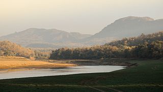
Satpura Tiger Reserve (STR) also known as Satpura National Park is located in the Narmadapuram district of Madhya Pradesh in India. Its name is derived from the Satpura range. It covers an area of 524 km2 (202 sq mi). Satpura National Park, along with the adjoining Bori and Pachmarhi wildlife sanctuaries, provides 2,200 km2 (850 sq mi) of unique central Indian highland ecosystem. It was set up in 1981.

The Eastern Highlands moist deciduous forests, presently known as East Deccan moist deciduous forests, is a tropical and subtropical moist broadleaf forests ecoregion in east-central India. The ecoregion covers an area of 341,100 square kilometers (131,700 sq mi), extending across portions of Andhra Pradesh, Chhattisgarh, Jharkhand, Madhya Pradesh, Maharashtra, Odisha, and Telangana states.

The Narmada Valley dry deciduous forests are a tropical dry forest ecoregion of central India. The ecoregion lies mostly in Madhya Pradesh state, but extends into portions of Chhattisgarh, Maharashtra, Karnataka and Uttar Pradesh states.
The Central Deccan Plateau dry deciduous forests in Western and Southern India, containing large protected areas of natural tiger habitat.

The state of Maharashtra in India has several major river systems including those of the Narmada, Tapti, Godavari and Krishna rivers. The ecology of these rivers and associated wetlands is covered in this article.
The Indian nuthatch is a species of bird in the family Sittidae. It is found in Bangladesh, India and Nepal.

The Geography of South India comprises the diverse topological and climatic patterns of South India. South India is a peninsula in the shape of a vast inverted triangle, bounded on the west by the Arabian Sea, on the east by the Bay of Bengal and on the north by the Vindhya and Satpura ranges.
Kaimur Wildlife Sanctuary is situated in Kaimur District and Rohtas District of Bihar. It is the largest sanctuary in the state and extended in area of 1,504.96 km2 (581.07 sq mi) in plateaued landscape of Kaimur Range. It was established in 1979. The major forest types are Tropical Dry Mixed Deciduous, Dry Sal Forests, Boswellia Forests and Dry Bamboo Brakes. It is home to rare and endangered flora and fauna. Rohtasgarh Fort and Shergarh Fort are also located in these forests. It also has numerous Megaliths, Rock painting of prehistoric age and stone inscription from a bygone era. The Government of Bihar has planned to developed it into Tiger Reserve.

Nauradehi Wildlife Sanctuary, covering about 1,197 km2 (462 sq mi), is the largest wildlife sanctuary of Madhya Pradesh state in India. This wildlife sanctuary is a part of 5500 km2 of forested landscape. It is located in the centre of the state covering parts of Sagar, Damoh, Narsinghpur, and Raisen Districts. It is about 90 km from Jabalpur and about 56 km from Sagar.

Biogeographic classification of India is the division of India according to biogeographic characteristics. Biogeography is the study of the distribution of species (biology), organisms, and ecosystems in geographic space and through geological time. India has a rich heritage of natural diversity. India ranks fourth in Asia and tenth in the world amongst the top 17 mega-diverse countries in the world. India harbours nearly 11% of the world's floral diversity comprising over 17500 documented flowering plants, 6200 endemic species, 7500 medicinal plants and 246 globally threatened species in only 2.4% of world's land area. India is also home to four biodiversity hotspots—Andaman & Nicobar Islands, Eastern Himalaya, Indo-Burma region, and the Western Ghats. Hence the importance of biogeographical study of India's natural heritage.
The Achanakmar-Amarkantak Biosphere Reserve is a biosphere reserve in India that extends across the states of Madhya Pradesh and Chhattisgarh, covering a total area of 383,551 hectares (3835.51 km2).
The Central Highlands of India is a large geological structure and biogeographic region located between the Deccan plateau and the Indo-Gangetic plains consisting of number of mountain ranges, including Vindhya and Aravali ranges, and the Chota Nagpur and Malwa plateaus. It is the single most important feature of Central India. It extends over three linguistic sub-regions of the Indo-Aryan language family and the languages chiefly spoken here are, from west to east, Marwari, Malwi, Bundeli, Bagheli, Chhattisgarhi and Maithili. The population is primarily Indo-Aryan along with a large population of Aboriginal tribes.
References
- Ali, S. 1949. The Satpura trend as an ornithogeographical highway. Proceedings of the National Institute of Sciences, India, 15:379-386.
- Ali, S. and S.D. Ripley, 1983. The Compact Handbook of the Birds of India and Pakistan. Oxford University Press, Bombay.
- Forsyth, J. 1889. The Highlands of Central India. Chapman and Hall, London.
- Grimmett, R., C. Inskipp, & T. Inskipp. 1998. Birds of the Indian Subcontinent. Oxford University Press, New Delhi.
- Jayapal, R., Q. Qureshi, & R. Chellam. 2005. Some significant records of birds from the central Indian highlands of Madhya Pradesh. Indian Birds, 1:98-102.
- Rasmussen, P. 1998. Rediscovery of an Indian enigma: the Forest Owlet. Bulletin of the Oriental Bird Club, 27:50-51.
- Rodgers, W.A. & Panwar H.S. 1988. Planning a Wildlife Protected Area Network in India vol I – The Report. Wildlife Institute of India, Dehra Dun.