Bidston is a village, a parish and a suburb of Birkenhead, on the Wirral Peninsula, in the modern county of Merseyside. The area is a mixture of the well-preserved Bidston Village, Bidston Hill, a modern housing estate, and the Bidston Moss nature reserve, industrial estate and retail park.

Bidston Windmill is situated on Bidston Hill, near Birkenhead, on the Wirral Peninsula, England.

Tranmere is a suburb of Birkenhead, on the Wirral Peninsula, England. Administratively, it is also a ward of the Metropolitan Borough of Wirral, in Merseyside. Before local government reorganisation on 1 April 1974, it was part of the County Borough of Birkenhead, within the geographical county of Cheshire. At the 2001 Census, the population of Tranmere was 11,668.

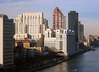
The Great Float is a body of water on the Wirral Peninsula, England, formed from the natural tidal inlet, the Wallasey Pool. It is split into two large docks, East Float and West Float, both part of the Birkenhead Docks complex. The docks run approximately 2 miles (3 km) inland from the River Mersey, dividing the towns of Birkenhead and Wallasey. The Great Float consists of 110 acres of water and more than 4 miles (6 km) of quays.
The Wirral Railway was a railway network in the northern part of the Wirral Peninsula, England. It was incorporated in 1863 as the Hoylake Railway, running from Hoylake to Birkenhead Docks. After changes of name and of ownership, it was purchased by the Wirral Railway Company Limited in 1884. The network was extended to West Kirby, New Brighton, and Seacombe, and to Birkenhead Park station where it joined the Mersey Railway, enabling through trains through the Mersey Railway Tunnel to Liverpool. In the 1923 grouping the Wirral company became part of the London, Midland and Scottish Railway, which electrified the line in 1938, allowing passenger services to be integrated with the Liverpool urban system. Most of the Wirral Railway network is still in use today as part of the Wirral Line of the Merseyrail commuter rail network.

Wallasey is a town within the Metropolitan Borough of Wirral, in Merseyside, England, on the mouth of the River Mersey, at the northeastern corner of the Wirral Peninsula. At the 2011 Census, the population was 60,284.

Birkenhead is a constituency recreated in 1950 represented in the House of Commons of the UK Parliament since 1979 by Frank Field, who currently sits as an independent MP, having been a member of the Parliamentary Labour Party until 30 August 2018. A former constituency of the same name existed from 1861-1918. In the intervening years, the area on the Liverpool-facing side of the Wirral Peninsula was split in two and joined with other land which had become more developed.

Bidston railway station is a railway station in Bidston, Birkenhead, on the Wirral, England. The station is situated at the junction of the West Kirby branch of the Wirral Line, which is part of the Merseyrail network, and with the Borderlands Line from Wrexham Central, operated by Transport for Wales. Bidston is the northern terminal of the Borderlands Line.

New Brighton railway station is situated in New Brighton, Wirral, England. It is situated at the end of the New Brighton branch of the Wirral Line 8.25 miles (13.28 km) west of Liverpool Lime Street on the Merseyrail network.

Birkenhead North railway station is situated in Birkenhead, Wirral, England. The station is situated on the Wirral Line of the Merseyrail network, close to the junction of the New Brighton and West Kirby branches. Birkenhead North TMD, situated just to the west of the station, is the main Traction Maintenance Depot for the Merseyrail fleet.

Bidston Hill is 100 acres (0.40 km2) of heathland and woodland that contains historic buildings and ancient rock carvings. It is located on the Wirral Peninsula, near the Birkenhead suburb of Bidston, in Merseyside, England. With a peak of 231 feet (70 m), Bidston Hill is one of the highest points on the Wirral. The land was part of Lord Vyner's estate and purchased by Birkenhead Corporation in 1894 for use by the public.
Wallasey Pool was a natural tidal inlet of water that separated the towns of Wallasey and Birkenhead on the Wirral Peninsula, England. Originally flowing directly into the River Mersey, it was converted into the sophisticated Birkenhead Dock system from the 1820s onwards by land reclamation, with the main portion of the pool becoming known as the Great Float. In 1933, with the exception of a small lake, the head of Wallasey Pool at Poulton was converted into Bidston Dock. By 2003, this dock had been filled in.

Birkenhead Dock Branch is a disused railway line running from the South junction of Rock Ferry, to the site of the former Bidston Dock on the Wirral Peninsula, England. The branch is approximately 4 1⁄2 miles (7.2 km) in length. Although called a branch, the line was accessible from both ends, from Bidston East junction and from Rock Ferry railway station. The former Mollington Street Rail Depot was branched into the line. A section of the line runs through Haymarket Tunnel and a low-level cutting through the centre of Birkenhead; visible from the road flyovers. The former Canning Street North signal box has now been demolished following fire damage, and the rails across the level crossing there have been removed due to the provision of cycle lanes on the roadway. The non-standard gates remain on the east side, but a fence has been erected on the other side despite the railway being officially out of use, rather than closed. Level crossings are also located at Duke Street and Wallasey Bridge Road. The railway lines are still partially intact.
Woodchurch is an area of Birkenhead on the Wirral Peninsula, in England. Administratively, Woodchurch is within the Metropolitan Borough of Wirral, its parliamentary constituency is Wirral West, and its local council ward is Upton. At the 2001 Census, it had a population of 8,400. Woodchurch is dominated by a large housing development, known as the Woodchurch Estate. The district is served by several schools and has the major Arrowe Park Hospital just outside its boundary, which was built on 15 acres (61,000 m2) of the park itself and opened in 1982.

Flaybrick Memorial Gardens is a memorial garden, formerly a municipal cemetery situated in Birkenhead, on the Wirral Peninsula, England. The cemetery has been designated a conservation area by Wirral Borough Council, which owns the site.
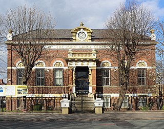
The Laird School of Art was a school of art situated on Park Road North, Birkenhead, Merseyside, England, overlooking Birkenhead Park. It was the first public school of art outside London and was given to the town by John Laird. The school opened on 27 September 1871 and was closed in 1980 when it merged with the Birkenhead College of Technology, formerly situated on Borough Road. The building on Park Road North is used as the John Laird Centre.

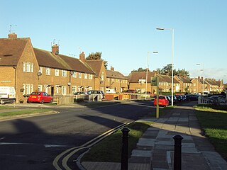
Beechwood is a housing estate situated between Bidston and Noctorum, to the west of Birkenhead on the Wirral Peninsula in England. The estate was built in the 1960s as the Ford Estate and completed in the mid to late 1970s, to house people moving from the North End of Birkenhead and providing a better standard of living.