Related Research Articles

Merseyside is a ceremonial and metropolitan county in North West England. It borders Lancashire to the north, Greater Manchester to the east, Cheshire to the south, the Welsh county of Flintshire across the Dee Estuary to the southwest, and the Irish Sea to the west. The largest settlement is the city of Liverpool.

Birkenhead is a town in the Metropolitan Borough of Wirral, Merseyside, England; historically, it was part of Cheshire until 1974. The town is on the Wirral Peninsula, along the west bank of the River Mersey, opposite Liverpool. At the 2011 census, it had a population of 88,818.

The Metropolitan Borough of Wirral is a metropolitan borough of Merseyside, in North West England. It has a population of 322,453 (2022), and encompasses 62 square miles (161 km2) of the northern part of the Wirral Peninsula. Major settlements include Birkenhead, Wallasey, Bebington, Heswall, Hoylake and West Kirby. Wirral is England's westernmost metropolitan borough, faced by the city of Liverpool to the northeast over the River Mersey.

Ellesmere Port is a port town in the Cheshire West and Chester borough in Cheshire, England. Ellesmere Port is on the south eastern edge of the Wirral Peninsula, six miles north of Chester, on the bank of the Manchester Ship Canal. The town had a population of 61,090 in the 2011 census. Ellesmere Port also forms part of the wider Birkenhead urban area, which had a population of 325,264 in 2011.

Neston is a market town and civil parish on the Wirral Peninsula, in Cheshire, England. It is part of the unitary authority of Cheshire West and Chester. The civil parish and wider suburban area includes Parkgate to the north west and Little Neston, Ness and part of Burton to the south.

Bebington is a town in the Metropolitan Borough of Wirral, in Merseyside, England. Historically part of Cheshire, it is 5 miles (8 km) south of Liverpool, close to the River Mersey on the eastern side of the Wirral Peninsula. Nearby towns include Birkenhead and Wallasey to the north-northwest, and Heswall to the west-southwest. Bebington railway station opened in 1838 and is on the Wirral line of the Merseyrail network.

Bromborough is a town in the Metropolitan Borough of Wirral, Merseyside, England, and the historic county of Cheshire, on the Wirral Peninsula southeast of Bebington and north of Eastham.

Tranmere is a suburb of Birkenhead, on the Wirral Peninsula, England. Administratively, it is within the Birkenhead and Tranmere Ward of the Metropolitan Borough of Wirral, in Merseyside. Before local government reorganisation on 1 April 1974, it was part of the County Borough of Birkenhead, within the county of Cheshire.

The Wirral Peninsula, known locally as the Wirral, is a peninsula in North West England. The roughly rectangular peninsula is about 15 miles (24 km) long and 7 miles (11 km) wide, and is bounded by the Dee Estuary to the west, the Mersey Estuary to the east, and Liverpool Bay to the north.

Birkenhead Priory is in Priory Street, Birkenhead, Merseyside, England. It is the oldest standing building on Merseyside. The site comprises the medieval remains of the priory itself, the priory chapter house, and the remains of St Marys church. All three are recorded in the National Heritage List for England, though at different grades.

The Greater Manchester Built-up Area is an area of land defined by the Office for National Statistics (ONS), consisting of the large conurbation that encompasses the urban element of the city of Manchester and the metropolitan area that forms much of Greater Manchester in North West England. According to the United Kingdom Census 2011, the Greater Manchester Built-up Area has a population of 2,553,379 making it the second most populous conurbation in the United Kingdom after the Greater London Built-up Area. This was an increase of 14% from the population recorded at the United Kingdom Census 2001 of 2,240,230, when it was known as the Greater Manchester Urban Area.

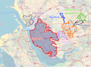
The Liverpool Built-up Area is a term used by the Office for National Statistics (ONS) to denote the urban area around Liverpool in England, to the east of the River Mersey. The contiguous built-up area extends beyond the area administered by Liverpool City Council into adjoining local authority areas, particularly parts of Sefton and Knowsley. As defined by ONS, the area extends as far east as St Helens, Haydock, and Ashton-in-Makerfield in Greater Manchester.
Wirral Rural District was a rural district on the Wirral Peninsula in Cheshire, England from 1894 to 1933. It was created under the Local Government Act 1894 from the Wirral Rural Sanitary District.

Birkenhead Woodside was a railway station located at Woodside, in Birkenhead, on the Wirral Peninsula, Cheshire. It served both local services within Cheshire and long-distance services to southern England, including London.

Noctorum is a suburb of Birkenhead, Merseyside, England. Administratively it is within the Metropolitan Borough of Wirral as part of Claughton Ward. Noctorum is in the north east of the Wirral Peninsula, bounded by the Beechwood estate to the north, Claughton and Oxton to the east and south east, and the River Fender and M53 motorway to the west.

Hooton is a suburban village and former civil parish on the Wirral Peninsula, within the unitary authority of Cheshire West and Chester and the ceremonial county of Cheshire, England. It was once a separate village but was incorporated into Ellesmere Port as the town expanded outwards during the twentieth century.

Claughton is a village and suburb of Birkenhead, on the Wirral Peninsula, Merseyside, England. It is situated approximately 3 km (1.9 mi) to the west of Birkenhead town centre, adjacent to Birkenhead Park. Administratively, Claughton is a ward of the Metropolitan Borough of Wirral. Before local government reorganisation on 1 April 1974, it was part of the County Borough of Birkenhead, within the county of Cheshire.

The Newport Built-up area is an area of land defined by the United Kingdom Office for National Statistics (ONS) for population monitoring purposes. It is an urban conurbation and is not coterminous with the city boundaries. It consists of the urban area centred on Newport as well as contiguous settlements in the eastern and western valleys extending north of the city – including Cwmbran, Pontypool, Risca, Abercarn and Blackwood. It does however exclude physically detached urban areas within the city boundaries, such as Marshfield.
The ceremonial county of Cheshire, which comprises the unitary authorities of Cheshire East, Cheshire West and Chester, Halton and Warrington, has returned 11 MPs to the UK Parliament since 1997.

The Wrexham Built-up area is an area of land defined by the United Kingdom Office for National Statistics (ONS) for population monitoring purposes. It is an urban conurbation fully within Wrexham County Borough and consists of the urban area centred on the city of Wrexham. Until the 2021 census, it also included the historically industrial settlements to the west including Gwersyllt, Rhostyllen, Brymbo, Bradley and New Broughton.
References
53°23′N3°01′W / 53.39°N 3.01°W