
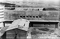
Birya Fortress is a fortress built by the Jewish Palmach paramilitary during the British Mandate near the Jewish village of Birya and the Arab village of Biriyya. In 1946 the Birya affair took place here. Today the fortress operates as a museum.
Birya Fortress is a fortress built by the Jewish Palmach paramilitary during the British Mandate near the Jewish village of Birya and the Arab village of Biriyya. In 1946 the Birya affair took place here. Today the fortress operates as a museum.
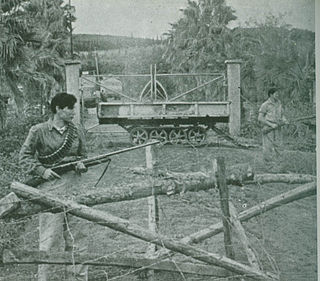
The fortress was built by the Palmach in 1946 as a base for the defense of Jews in nearby Safed and as a way-station for Jewish immigrants arriving from Syria. Because iron was scarce, the double walls were constructed from stone topped by a vaulted roof fitted with drainpipes and channels to channel rainwater into a reservoir. The fortress had two watchtowers and a lookout. These towers served as a means of communication with the Jewish community in Safed and the Upper Galilee headquarters of the Haganah in Kibbutz Ayelet HaShahar. [1]
On February 28, 1946, the British raided the site and discovered an arms cache, leading to the arrest of all residents of Birya and a ban on Jewish settlement there. However, after mass protests and resettlement attempts, the British withdrew.
In the 1948 Arab–Israeli War the site was destroyed but later reconquered by Jewish forces. After the war it served for several years as a camp for new immigrants, and was later abandoned.
In 1971 the modern community of Birya was established, about two kilometers to the southwest of the original site. The fortress was turned into a museum explaining the history of the area. It is now surrounded by Birya Forest.


Haganah was the main Zionist paramilitary organization that operated for the Yishuv in the British Mandate for Palestine. It was founded in 1920 to defend the Yishuv's presence in the region, and was formally disbanded in 1948, when it became the core force integrated into the Israel Defense Forces shortly after the Israeli Declaration of Independence.
Latrun is a strategic hilltop in the Latrun salient in the Ayalon Valley. It overlooks the road between Tel Aviv and Jerusalem, 25 kilometers west of Jerusalem and 14 kilometers southeast of Ramla. It was the site of fierce fighting during the 1948 war. During the period of 1949–1967, it was occupied by Jordan at the edge of a no man's land between the armistice lines. In the 1967 war, it was occupied by Israel.

Safed is a city in the Northern District of Israel. Located at an elevation of up to 937 m (3,074 ft), Safed is the highest city in the Galilee and in Israel.

The Palmach was the elite combined strike forces and sayeret unit of the Haganah, the underground army of the Yishuv during the period of the British Mandate for Palestine. The Palmach was established in May 1941. By the outbreak of the 1948 Arab–Israeli War, it consisted of over 2,000 men and women in three fighting brigades and auxiliary aerial, naval and intelligence units. With the creation of Israel's army, the three Palmach Brigades were disbanded. This and political reasons compelled many of the senior Palmach officers to resign in 1950.

Mount Herzl, also Har ha-Zikaron, is the site of Israel's national cemetery and other memorial and educational facilities, found on the west side of Jerusalem beside the Jerusalem Forest.

Katamon or Qatamon, officially known as Gonen, is a neighborhood in south-central Jerusalem. It is built next to an old Greek Orthodox monastery, believed to have been constructed on the home and the tomb of Simeon from the Gospel of Luke.

The Convoy of 35, was a convoy of Haganah and Palmach fighters sent during the 1947–48 Civil War in Mandatory Palestine on a mission to reach by foot and resupply the blockaded kibbutzim of Gush Etzion in January 1948, after earlier motorized convoys had been attacked. They were spotted before they could reach their destination and killed in a prolonged battle by Arab irregulars and local villagers.

Ein Gev is a kibbutz in northern Israel. Located on the eastern shore of the Sea of Galilee near the ruins of the Greco-Roman settlement of Hippos, it falls under the jurisdiction of Emek HaYarden Regional Council. In 2022 its population was 666.
Yehiam is a kibbutz in northern Israel. Located at the western Upper Galilee, eight miles east of the coastal town of Nahariya and 14 miles south-east of the border with Lebanon it falls under the jurisdiction of Mateh Asher Regional Council. In 2022 it had a population of 778. It is located around 365 meters above sea level
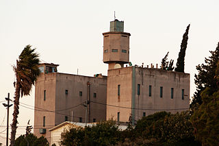
Metzudat Koach is a British Mandate police fort built during the 1936–39 Arab revolt in Palestine. On the grounds of the fort are a memorial monument and a museum founded in 2014. The Metzudat Koach Memorial commemorates 28 Israeli soldiers who fell in battle during the conquest of the fort in 1948.

Mishmar HaEmek is a kibbutz in northern Israel. Located in the western Jezreel Valley, it falls under the jurisdiction of the Megiddo Regional Council. Mishmar HaEmek is one of the few kibbutzim that have not undergone privatization and still follow the traditional collectivist and socialist kibbutz model. In 2022, it had a population of 1,278. At least six former members of the Knesset hail from Mishmar HaEmek.

Birya is an agricultural village in northern Israel. Located in the Upper Galilee near Safed, it falls under the jurisdiction of the Merom HaGalil Regional Council. As of 2022 its population was 872.

Neve Ilan is a moshav shitufi in central Israel. Located west of Jerusalem, it falls under the jurisdiction of Mateh Yehuda Regional Council. In 2022 it had a population of 1,024. Previously a kibbutz, it remains a member of the Kibbutz Movement despite its change in status to a moshav.

A successful paramilitary campaign, sometimes referred to as the Palestine Emergency, was carried out by Zionist underground groups against British rule in Mandatory Palestine from 1944 to 1948. The tensions between the Zionist underground and the British mandatory authorities rose from 1938 and intensified with the publication of the White Paper of 1939. The Paper outlined new government policies to place further restrictions on Jewish immigration and land purchases, and declared the intention of giving independence to Palestine, with an Arab majority, within ten years. Though World War II brought relative calm, tensions again escalated into an armed struggle towards the end of the war, when it became clear that the Axis powers were close to defeat.

The Battles of Latrun were a series of military engagements between the Israel Defense Forces and the Jordanian Arab Legion on the outskirts of Latrun between 25 May and 18 July 1948, during the 1948 Arab–Israeli War. Latrun takes its name from the monastery close to the junction of two major highways: Jerusalem to Jaffa/Tel Aviv and Gaza to Ramallah. During the British Mandate it became a Palestine Police base with a Tegart fort. The United Nations Resolution 181 placed this area within the proposed Arab state. In May 1948, it was under the control of the Arab Legion. It commanded the only road linking the Yishuv-controlled area of Jerusalem to Israel, giving Latrun strategic importance in the battle for Jerusalem.
Operation Yiftach was a Palmach offensive carried out between 28 April and 23 May 1948. The objectives were to capture Safed and to secure the eastern Galilee before the British Mandate ended on 14 May 1948. It was carried out by two Palmach battalions commanded by Yigal Allon.
The Battle of Mishmar HaEmek was a ten-day battle fought from 4 to 15 April 1948 between the Arab Liberation Army commanded by Fawzi al-Qawuqji and the Haganah commanded by Yitzhak Sadeh and Dan Laner. The battle began when al-Qawuqji launched an attack against Mishmar HaEmek with the intent of taking the kibbutz, which was strategically placed beside the main road between Jenin and Haifa. In 1947 it had a population of 550.

Biriyya was a Palestinian Arab village in the Safad Subdistrict. It was depopulated during the 1947–1948 Civil War in Mandatory Palestine on May 2, 1948, by The Palmach's First Battalion of Operation Yiftach. It was located 1.5 kilometres (0.9 mi) northeast of Safad. Today the Israeli moshav of Birya includes the village site.

Shimon HaTzadik is an Israeli settlement in East Jerusalem, established around the Tomb of Simeon the Just, after whom it was named. The neighborhood was established in 1890 and abandoned during the 1948 Palestine war. At the beginning of the new millennium after a long legal battle, Jewish residents settled down in the area near the Arab neighborhood of Sheikh Jarrah.
Meir Meivar, was the Haganah commander of the city of Safed during the 1948 Arab–Israeli War. Meivar was the mayor of Safed in 1965–1966.