Garmen Point is a point on the northwest coast of Smith Island, South Shetland Islands situated 13.65 km north-northeast of Cape James, 6.12 km south-southwest of Markeli Point and 19.65 km southwest of Cape Smith. Formed by an offshoot of Mount Foster. Bulgarian early mapping in 2008. Named after the settlement of Garmen in southwestern Bulgaria.

Butamya Glacier is the 6.9 km long and 2.5 km wide glacier on Barison Peninsula, Graham Coast on the west side of Antarctic Peninsula, situated northwest of Talev Glacier and north-northeast of Chernomen Glacier. It drains northwards, and flows into Beascochea Bay.

Pripek Point is the point forming the west side of the entrance to Dimitrov Cove on the northwest coast of Velingrad Peninsula on Graham Coast in Graham Land, Antarctica.
Dimitrov Cove is the 6.8 km wide cove indenting for 4.8 km the northwest coast of Velingrad Peninsula on Graham Coast in Graham Land, Antarctica, which is entered between Pripek Point to the west and Biser Point to the east. Hoek Glacier and Rusalka Glacier flow into the cove, their termini separated by Veshka Point, while Camacúa Island is lying at the cove's entrance.

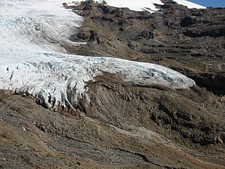
Diralo Point is the rocky point at the southeast extremity of Metlichina Ridge, forming the north side of the entrance to Borima Bay on Oscar II Coast, Graham Land in Antarctica. It was formed as a result of the disintegration of Larsen Ice Shelf in the area in 2002 and the subsequent retreat of Jorum Glacier.
Furen Point is the rocky point on Oscar II Coast, Graham Land in Antarctica formed by an offshoot of Yordanov Nunatak, and situated on the northwest coast of Borima Bay. It was formed as a result of the disintegration of Larsen Ice Shelf in the area in 2002 and the subsequent retreat of Jorum Glacier and Minzuhar Glacier.

Samotino Point is the ice-covered point on the southeast side of the entrance to Pizos Bay on Nordenskjöld Coast in Graham Land, Antarctica. It was formed as a result of glacier retreat in the last decade of 20th century.
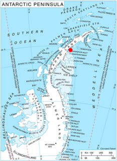
Daskot Point is the ice-covered point on the north side of the entrance to Yamforina Cove on Blagoevgrad Peninsula, Oscar II Coast in Graham Land, Antarctica. It was formed as a result of the break-up of Larsen Ice Shelf in the area in 2002.
Kalina Point is the rocky point on the south side of the entrance to Domlyan Bay on Oscar II Coast in Graham Land. It is situated at the east extremity of Parlichev Ridge, and was formed as a result of the break-up of Larsen Ice Shelf in the area, and the retreat of Melville Glacier in the early 21st century. The feature is named after the settlements of Kalina in Northwestern and Northeastern Bulgaria.
Sandilh Point is the partly ice-free point on the northwest side of the entrance to Durostorum Bay on Oscar II Coast in Graham Land. It is situated at the east extremity of Tepava Ridge, and was formed as a result of the break-up of Larsen Ice Shelf in the area, and the retreat of Pequod Glacier in the early 21st century. Named after the Bulgar ruler Sandilh.

Ranyari Point is the rounded ice-covered point on the southeast side of the entrance to Durostorum Bay on Oscar II Coast in Graham Land. It is situated on the north coast of Akra Peninsula, and was formed as a result of the break-up of Larsen Ice Shelf in the area in the early 21st century. Named after the Bulgar ruler Ranyari.

Vartop Point is the point on the northwest side of the entrance to Finaeus Cove on the northeast coast of Magnier Peninsula, Graham Coast on the Antarctic Peninsula.

Laskar Point is the point on the northwest side of the entrance to Urovene Cove on the southwest coast of Felipe Solo (Obligado) Peninsula, Graham Coast on the Antarctic Peninsula.

Plakuder Point is the point on the east side of the entrance to Misionis Bay on the northeast coast of Pickwick Island in the Pitt group of Biscoe Islands, Antarctica.

Strelcha Spur is the rocky, partly ice-covered spur extending 5.3 km in south-southeast to north-northwest direction and 1.4 km wide, rising to 650 m in the west foothills of Bruce Plateau on Graham Coast in Graham Land, Antarctica. It has steep and partly ice-free west, north and east slopes, and surmounts Birley Glacier to the north and east, and a tributary to that glacier to the west.
Vardun Point is the point projecting 1 km into the head of Barilari Bay on Graham Coast in Graham Land, Antarctica, formed by an offshoot of Mitino Buttress. The point is named after the settlement of Vardun in Northeastern Bulgaria.
Cherkovna Point is the sharp point projecting 1.7 km into the head of Barilari Bay on Graham Coast in Graham Land, Antarctica, formed by an offshoot of Mezzo Buttress. The point is named after the settlements of Cherkovna in Northeastern Bulgaria.
Veshka Point is the point projecting 1.4 km into Dimitrov Cove on the north coast of Velingrad Peninsula, Graham Coast in Graham Land, Antarctica, and separating the glacier termini of Hoek Glacier to the southwest and Rusalka Glacier to the northeast. It is named after Veshka Peak in the Rhodope Mountains, Bulgaria.

Sokol Point is the narrow hilly point projecting 1.9 km into Darbel Bay on Loubet Coast in Graham Land, Antarctica. It is formed by an offshoot of Sherba Ridge, and separates the glacier termini of Drummond Glacier to the east and Widdowson Glacier to the south.

Sursuvul Point is the rocky point on Davis Coast in Graham Land, Antarctica projecting 300 m northwards into Orléans Strait. The point is named after Georgi Sursuvul, first minister and regent of Bulgaria during the reigns of Czar Simeon the Great and Czar Peter I.