
Killeen–Fort Hood Regional Airport is a small military/commercial joint-use airport that operates alongside Robert Gray Army Airfield. The airport is based inside the south end of the Fort Hood Military Reservation, six nautical miles southwest of the central business district of Killeen, Texas, in unincorporated Bell County. The commercial side replaced the old Killeen Municipal Airport, which was unable to expand.

Lancaster Regional Airport is a city-owned, public-use airport located two nautical miles (4 km) south of the central business district of Lancaster, a city in Dallas County, Texas, United States. Formerly known as Lancaster Airport, it is included in the National Plan of Integrated Airport Systems for 2011–2015, which categorized it as a general aviation reliever airport.

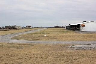
Lane Field is a privately owned, public use airport located two nautical miles (4 km) east of the central business district of Sanger, in Denton County, Texas, United States. The airport is used solely for general aviation purposes.

Arlington Municipal Airport is a public use airport located four nautical miles (7 km) south of the central business district of Arlington, a city in Tarrant County, Texas, United States. The airport is at the intersection of Interstate 20 and South Collins Road. This airport is publicly owned by the City of Arlington and serves as a reliever airport for Dallas/Fort Worth International Airport and Dallas Love Field.

San Marcos Regional Airport is a public use airport located in Caldwell County, Texas, United States. It is four nautical miles (7 km) east of the central business district of San Marcos, a city that is mostly in Hays County. The airport is owned by the City of San Marcos and operated by Texas Aviation Partners. It is located east of the border of Caldwell County and Hays County. Before it was operated as a civilian airport it was known as Gary Air Force Base.
Chambers County-Winnie Stowell Airport is a county-owned public-use airport located in Chambers County, Texas, United States. The airport is named after the unincorporated communities of Winnie and Stowell, both located east of the airport. It is also known as Tom Jenkins Memorial Airport.
Liberty Municipal Airport is a public use airport in Liberty County, Texas, United States. It is owned by the City of Liberty and is located six nautical miles (11 km) northeast of its central business district.
Kickapoo Downtown Airport is a city-owned public use airport located three nautical miles (6 km) south of the central business district of Wichita Falls, a city in Wichita County, Texas, United States.
Albany Municipal Airport is a city-owned public-use airport located two nautical miles (3.7 km) east of the central business district of Albany, a city in Shackelford County, Texas, United States.
Bishop Municipal Airport is a city-owned public-use airport located three nautical miles northeast of the central business district of Bishop, a city in Nueces County, Texas, United States.
Ferris Red Oak Muni Heliport is a city-owned public heliport in Ellis County, Texas, United States, serving the cities of Ferris, Texas and Red Oak, Texas. The heliport has no IATA or ICAO designation. The facility is alternately known as the Ferris Red Oak Municipal Heliport.
Dallas South Port Airport is a privately owned public airport in Ferris, Ellis County, United States, that also serves the city Palmer, Texas, being located approximately 3 nautical miles (5.6 km) north of the central business district. The airport has no IATA or ICAO designation.
Dallas CBD Vertiport is a city-owned public heliport/vertiport in the city of Dallas, Dallas County, Texas, United States. The facility is located at the south end of the Kay Bailey Hutchison Convention Center in the Dallas Central Business District, and is claimed to be the world's largest elevated heliport/vertiport.
Rhome Meadows Airport is a privately owned public airport in Rhome, Wise County, Texas, United States, located approximately 6 nautical miles (11 km) north of the central business district. The airport has no IATA or ICAO designation.
Heritage Creek Airstrip is a privately owned public airport in Rhome, Wise County, Texas, United States that also serves the city of Decatur, being located approximately 9 nautical miles (17 km) southeast of the central business district. The airport has no IATA or ICAO designation.
Lazy G Bar Ranch Airport is a privately owned public airport in Decatur, Wise County, Texas, United States, located approximately 5 nautical miles (9.3 km) northeast of the central business district. The airport has no IATA or ICAO designation.
Clark Airport is a privately owned public airport in Justin, Denton County, Texas, United States, located approximately 3 nautical miles (5.6 km) south of the central business district. The airport has no IATA or ICAO designation.
Bishop's Landing Airport is a privately owned public airport in Celina, Collin County, Texas, United States, located approximately 5 nautical miles (9.3 km) northeast of the central business district. The airport has no IATA or ICAO designation.
Four Winds Airport is a privately owned public airport in Celina, Collin County, Texas, United States, located approximately 3 nautical miles (5.6 km) northeast of the central business district. The airport has no IATA or ICAO designation.
Van Zandt County Regional Airport is a city-owned public airport in Wills Point, Van Zandt County, Texas, United States, located approximately 3 nautical miles (5.6 km) southeast of the central business district. The airport has no IATA or ICAO designation.


