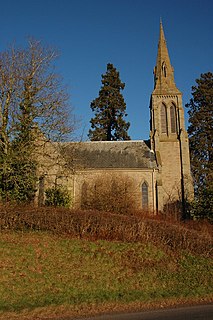
Yazor is a small village and civil parish in the English county of Herefordshire. The parish includes the hamlet of Yarsop about 1 mile (2 km) to the north. Yazor is some 8 miles (13 km) north west of the city of Hereford on the A480 road and about 1 mile (2 km) east of Offa's Dyke. It was formerly served by Moorhampton railway station located in the parish. The population of the parish at the 2011 Census was 122.

Bartestree is a village and civil parish in Herefordshire, England, 7 km (4.3 mi) east of Hereford on the A438 road. The population of the civil parish at the 2011 census was 330.

Bishop's Frome is a village and civil parish in eastern Herefordshire, England. The population of the civil parish at the 2011 census was 834. It is 21 km (13 mi) northeast of the City of Hereford, 16 km (9.9 mi) west of Malvern, Worcestershire and 8 km (5.0 mi) south of Bromyard. As the name indicates, it is on the River Frome.
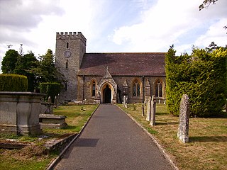
Pipe and Lyde is a village and civil parish in Herefordshire, England. The parish includes Pipe and Lyde itself, Lower Lyde and Upper Lyde. The population of the civil parish as taken at the 2011 census was 344. Parts of the church of St Peter date from the 13th century including the south door which features Transitional moulding. James Honeyman-Scott (1956-1982), the Pretenders guitarist, is buried in the churchyard.
Haywood is a civil parish in Herefordshire, England, which is south-west of Hereford. The population of this civil parish at the 2011 census was 216. The parish has no substantial settlements. However, it is home to one of the largest poultry farms in Great Britain, which is run by Cargill Meats Europe.
Birley with Upper Hill is a civil parish in Herefordshire, England, consisting of Birley and Upper Hill. According to the 2001 census it had a population of 321, increasing to 339 at the 2011 census.

Byford is a village and civil parish on the River Wye in Herefordshire, England, about 11 km (7 mi) west of Hereford. According to the 2001 census it had a population of 119, increasing to 201 at the 2011 Census.
Byton is a village and civil parish in Herefordshire, England., Byton is situated on the River Lugg near the border with Wales. According to the 2001 census it had a population of 93, increasing to 184 at the 2011 census.
Walford, Letton and Newton is a civil parish in north Herefordshire, England, close to the border with Shropshire. The population of this civil parish at the 2011 census was 179.
Warham is a place in the English county of Herefordshire. It is situated about 3 km west of the city of Hereford, close to the north bank of the River Wye. The population of the village at the 2011 census was 193.
Pixley is a village and civil parish in Herefordshire, England. The population of the civil parish at the 2011 census was 258. The village consists of a church and small farming community. Pixley Berries produce juice for the local markets. There is a local online news channel, The Pixley Reporter, residents of the parish and surrounding area are invited to contribute anything that is happening as it is an open forum.

Moccas is a village and civil parish in the English county of Herefordshire. It is located 14 miles (23 km) west of Hereford. The population of the civil parish taken at the 2011 census was 105.

Wacton is a small village and civil parish in the English county of Herefordshire. It is located 5 kilometres (3 mi) north west of Bromyard. The population of the civil parish at the 2011 census was 106.

Upper Sapey is a small village and civil parish in Herefordshire, England. It is located 4 miles (6 km) northeast of Bromyard. The population of this civil parish as taken at the 2011 census was 460.
Preston Wynne is a small village and civil parish in Herefordshire, England located 7 miles (11 km) north east of Hereford, and 12 miles (19 km) south east of Leominster. The population of this civil parish at the 2011 census was 172. It is the site of a medieval chapel and several ancient ring ditches.
Titley is a village and civil parish in Herefordshire, England. It lies on the B4355 between Kington and Presteigne.

Kingsland is a small village and civil parish in the English county of Herefordshire. It is located 5 kilometres (3 mi) north-west of Leominster. The population of the civil parish at the 2011 census was 986.

Stretton Grandison is a hamlet and small civil parish in Herefordshire, England. The population of the civil parish at the 2011 census was 175.
Monkland and Stretford is a civil parish in the English county and unitary authority of Herefordshire. The population of the civil parish at the 2011 census was 178.

Luston is a village and civil parish in north Herefordshire. It is 1.8 miles north of Leominster on the B4361 road. The parish contains the main village and the hamlet of The Broad which is south of the main village. The population of the civil parish at the 2011 census was 541.


