
Tyne and Wear is a ceremonial county in North East England. It borders Northumberland to the north and County Durham to the south, and the largest settlement is the city of Newcastle upon Tyne.

Sunderland is a port city in Tyne and Wear, England. It is a port at the mouth of the River Wear on the North Sea, approximately 10 miles (16 km) south-east of Newcastle upon Tyne. The built-up area had a population of 168,277 at the 2021 census, making it the second largest settlement in North East England after Newcastle. It is the administrative centre of the metropolitan borough of the same name.

Seaham is a seaside town in County Durham, England. Located on the Durham Coast, Seaham is situated 6 miles south of Sunderland and 13 miles (21 km) east of Durham. The town grew from the late 19th century onwards as a result of investments in its harbour and coal mines. The town is twinned with the German town of Gerlingen.

County Durham, officially simply Durham (/ˈdʌrəm/), is a ceremonial county in North East England. The county borders Northumberland and Tyne and Wear to the north, the North Sea to the east, North Yorkshire to the south, and Cumbria to the west. The largest settlement is Darlington.

Sunderland, also known as the City of Sunderland, is a metropolitan borough with city status in the metropolitan county of Tyne and Wear, England. It is named after its largest settlement, Sunderland, spanning a far larger area, including nearby towns including Washington, Hetton-le-Hole and Houghton-le-Spring, as well as the surrounding villages and hamlets. The district also forms a large majority of Wearside which includes Chester-le-Street in County Durham.

Ryhope is a coastal village along the southern boundary of the City of Sunderland, in Tyne and Wear, England. With a population of approximately 14,000, measured at 10.484 in the 2011 census, Ryhope is 2.9 miles to the centre of Sunderland, 2.8 miles to the centre of Seaham, and 1.2 miles from the main A19.
Newbottle is a village in the Sunderland district, in Tyne and Wear, England. The village is situated between Durham 8 miles (13 km) and Sunderland is 5 miles (8.0 km). It was historically a part of County Durham.
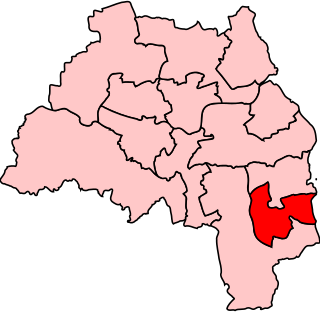
Sunderland South was, from 1950 until 2010, a constituency represented in the House of Commons of the Parliament of the United Kingdom. It elected one Member of Parliament (MP) by the first past the post system of election.

Whitburn is a village in South Tyneside, in the metropolitan county of Tyne and Wear on the coast of North East England. It is located 3 miles (4.8 km) north of the city of Sunderland and 4 miles (6.4 km) south of the town of South Shields. Historically, Whitburn is part of County Durham. Other nearby population centres include Seaburn, Cleadon and Marsden. The village lies on a south-facing slope, part of Durham's Magnesian Limestone plateau, which overlooks Sunderland. The population for the combined Whitburn and Marsden Ward in the 2011 UK Census was 7,448. For much of its history, Whitburn was a fishing and agricultural community. The village contains three schools, three churches, a cricket club, recreational grounds, a pub and a variety of shops.
Silksworth is a suburb of the City of Sunderland, Tyne and Wear. The area can be distinguished into two parts, old Silksworth, the original village and township which has existed since the early middle ages, and New Silksworth, the industrial age colliery village which expanded north west of the original settlement. The former colliery being situated to the north west of the village near to the Gilley Law. The population of the ward was 10,931 at the 2011 census.
South Hylton is a suburb of Sunderland, Tyne and Wear, England. Lying west of Sunderland city centre on the south bank of the River Wear, South Hylton has a population of 10,317. Once a small industrial village, South Hylton is now a dormitory village and is a single track terminus for the Tyne and Wear Metro.

Doxford Park is a suburb of Sunderland, Tyne and Wear, located to the south-west of the city centre. Once part of the historical township of Silksworth in the Middle Ages, Doxford Park consisted of agrarian land and a manor before being constructed into a modern housing estate in the 1960s. Surrounded by the A19, the suburb now houses one of the city's largest business districts, the Doxford International Business Park.

The Minster Church of St Michael and All Angels and St Benedict Biscop is the minster church of Sunderland, Tyne and Wear, England. Formerly known as "St Michael & All Angels' Church", it served as the parish church for Bishopwearmouth, but was renamed in January 1998 after Sunderland was granted city status. In May 2007 the Minster ceased to be the parish church of Bishopwearmouth and village is now a suburb of Sunderland. Sunderland Minster is part of the Greater Churches Group.

Farringdon is a suburb of Sunderland, Tyne and Wear, England. Originally a Monastic grange and manor estate for hundreds of years, Farringdon was rebuilt as a post-war council housing estate in the 1950s. It is approximately 3 mi (4.8 km) south of the city centre along the A690, close to Thorney Close, Silksworth, East Herrington, Gilley Law and Doxford Park. Electorally, the area comes under the St. Chad's ward of the City.

Tunstall is a suburb of Sunderland, Tyne and Wear, England which is mostly a privately purchased estate. It is located to the west of Ryhope, and east of Silksworth. The area was built around a large hill, known as Tunstall Hill. Since 1966 pilgrims have erected crucifixes on the hill every Good Friday.

Bishopwearmouth is a former village and parish which now constitutes the west side of Sunderland City Centre, in the county of Tyne and Wear, England, merging with the settlement as it expanded outwards in the 18th and 19th centuries. It is home to the Sunderland Minster church, which has stood at the heart of the settlement since the early Middle Ages. Until 1974 it was in County Durham.

Holy Trinity Church is an Anglican church building in Sunderland, Tyne and Wear formerly the area's parish church. It was opened in 1719 as the church for the newly created Parish of Sunderland, and served the local community until dwindling numbers forced its closure in 1988. It has since been in the ownership of the Churches Conservation Trust who have preserved the space and converted it into a community cultural hub.

Bishopwearmouth Cemetery is a cemetery in Sunderland, Tyne and Wear, England. It lies between Hylton Road and Chester Road.

In 685, King Ecgfrith granted Benedict Biscop a "sunder-land". Also in 685 The Venerable Bede moved to the newly founded Jarrow monastery. He had started his monastic career at Monkwearmouth monastery and later wrote that he was "ácenned on sundorlande þæs ylcan mynstres". This can be taken as "sundorlande" or the settlement of Sunderland. Alternatively, it is possible that Sunderland was later named in honour of Bede's connections to the area by people familiar with this statement of his.

Sunderland Barracks was a military installation in the old east end of Sunderland, built as part of the British response to the threat of the French Revolution.
