
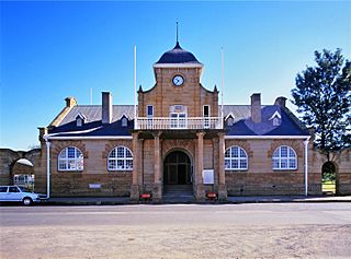
Kruger National Park is a South African National Park and one of the largest game reserves in Africa. It covers an area of 19,623 km2 (7,576 sq mi) in the provinces of Limpopo and Mpumalanga in northeastern South Africa, and extends 360 km (220 mi) from north to south and 65 km (40 mi) from east to west. The administrative headquarters are in Skukuza. Areas of the park were first protected by the government of the South African Republic in 1898, and it became South Africa's first national park in 1926.

The Maputo River, also called Great Usutu River, Lusutfu River, or Suthu River, is a river in South Africa, Eswatini, and Mozambique. The name Suthu refers to Basotho people who lived near the source of the river, but were attacked and displaced by Swazis. It is also said to mean 'dark brown', a description of the river's muddy water.

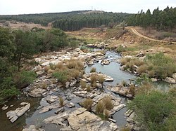
Ithala Game Reserve is situated in 290 km2 of rugged, mountainous thornveld, about 400 km north of Durban, in northern KwaZulu-Natal, South Africa. It is one of the youngest game parks in South Africa. The altitude varies from 400 m along the Phongolo River to 1,450 m along the Ngotshe Mountain escarpment. The reserve consequently encompasses a great variation of terrain, from densely vegetated river valleys and lowveld to sourveld, high-lying grassland plateaus, mountain ridges and cliff faces.
Utrecht is a town in the foothills of the Balele Mountains, in the northwestern corner of KwaZulu-Natal, South Africa. Newcastle, Kwazulu-Natal's third-largest urban centre, is 50 km from Utrecht. Utrecht has a population of approximately 32,000.
Pongola is a town on the north bank of the Phongolo River, in a fertile valley on the N2, near the Lubombo Mountains, in the valleys of Zululand, easily accessible to the Swaziland border posts. It was part of the Transvaal panhandle between the Phongolo (Natal) and Swaziland until 1994, when it was transferred to KwaZulu-Natal.

The Highveld is the portion of the South African inland plateau which has an altitude above roughly 1500 m, but below 2100 m, thus excluding the Lesotho mountain regions to the south-east of the Highveld. It is home to some of the country's most important commercial farming areas, as well as its largest concentration of metropolitan centres, especially the Gauteng conurbation, which accommodates one-third of South Africa's population.

The R33 is a provincial route in South Africa that connects Pietermaritzburg with Lephalale via Greytown, Paulpietersburg, Carolina, Belfast and Vaalwater. It is a very long road, passing through 3 provinces.

The Harts River is a northern tributary of the Vaal River, which in turn is the largest tributary of the Orange River. Its source is in the North West Province, but the greater part of its basin is located in the Northern Cape Province, which it enters a few kilometers downstream from the Taung Dam.

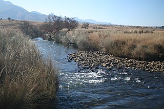
The Pongola or Phongolo River is a river in South Africa. It is a tributary of the Maputo River. It rises near Utrecht in northern KwaZulu-Natal, flows east through Pongola, is dammed at Pongolapoort, and crosses the Ubombo Mountains; then it flows north towards Mozambique, joining the Maputo River.
The Mzingwane River, formerly known Umzingwane River as or Umzingwani River is a major left-bank tributary of the Limpopo River in Zimbabwe. It rises near Fort Usher, Matobo District, south of Bulawayo and flows into the Limpopo River near Beitbridge, downstream of the mouth of the Shashe River and upstream of the mouth of the Bubye River.

uPhongolo Local Municipality, is a local municipality in the northern area of Zululand, in the South African province of KwaZulu-Natal.

Blyde River Canyon Nature Reserve is situated in the Drakensberg escarpment region of eastern Mpumalanga, South Africa. The reserve protects the Blyde River Canyon, including sections of the Ohrigstad and Blyde Rivers and the geological formations around Bourke's Luck Potholes, where the Treur River tumbles into the Blyde below. Southwards of the canyon, the reserve follows the escarpment, to include the Devil's and God's Window, the latter a popular viewpoint to the lowveld at the reserve's southern extremity.
Inkomati WMA, or Inkomati Water Management Area , in South Africa is situated in the north-eastern part of South Africa in the Mpumalanga Province, with a small area in the Limpopo Province. It borders on Mozambique in the east and on Swaziland in the south-east. The water management area extends over several parallel river catchments which all drain in a general easterly direction, and flow together at the border with Mozambique or within Mozambique, to form the Incomati River which discharges into the Indian Ocean immediately north of Maputo. A special situation is presented by the Komati River, the most southern tributary of the Incomati River, which rises in South Africa and flows into Swaziland, then re-enters South Africa where it is joined by the Crocodile River at the border with Mozambique, before flowing into Mozambique as the Incomati River. The Sabie River is the other main river in the water management area and flows into Corumuna Dam in Mozambique just downstream of the border with South Africa, and upstream of its confluence with the Inkomati River.
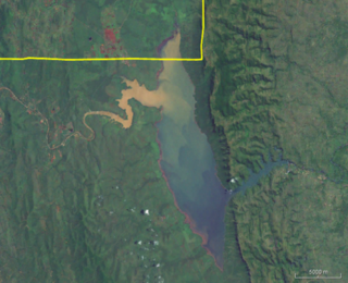
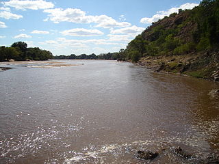
Pongolapoort Dam, commonly referred to as Jozini Dam creating Lake Jozini, is an arch type dam in northern KwaZulu-Natal, South Africa located on the Phongolo River. The dam is situated just north of the settlement of Jozini, 280 km north-east of the port city of Durban. The dam was constructed in 1973 at the eastern end of the narrow gorge separating the Lebombo and Ubombo ranges. The dam mainly serves for irrigation purposes and its hazard potential has been ranked high (3). The Phongolo River is the dam's largest feeder and outlet as well as the dam's only perennial feeder.

The Motlatse River, Blyde River, or Umdhlazi River is a river in the Mpumalanga and Limpopo provinces of South Africa. It has a northwards course in steep-sided valleys and ravines of the Mpumalanga Drakensberg, before it enters the lowveld region of the Limpopo province. It has its ultimate origins at around 2,000 m altitude in the Hartebeesvlakte conservation area, to the north of Long Tom Pass. It runs through the Blyde River Canyon.
The Crocodile River, also referred to as Crocodile River (East), is a large river traversing Mpumalanga province of South Africa. It is a tributary of the Komati River.

Severe Tropical Storm Domoina in 1984 caused 100-year floods in South Africa and record rainfall in Swaziland. The fourth named storm of the season, Domoina developed on January 16 off the northeast coast of Madagascar. With a ridge to the north, the storm tracked generally westward and later southwestward. On January 21, Domoina struck eastern Madagascar, the third storm in six weeks to affect the nation; collectively, the storms caused 242 deaths and $25 million in damage (1984 USD). After crossing the country, Domoina strengthened in the Mozambique Channel to peak 10-minute sustained winds of 95 km/h (60 mph). On January 28, the storm made landfall in southern Mozambique, and slowly weakened over land. Domoina crossed into Swaziland and later eastern South Africa before dissipating on February 2.
The Kruger National Park is a South African National Park and one of the largest game reserves in Africa. Originally known as The Sabi Game Reserve, it became a game reserve in 1898. The park became known as Kruger National Park in 1926, when it was named after Paul Kruger.

Shingwedzi is a rest camp and ranger's post situated in the northern section of the Kruger National Park. They are located on the southern bank of the Shingwedzi River, for which they were named, in Limpopo province, South Africa. The surrounding country formerly constituted the Singwitsi Reserve, proclaimed in 1903, which encompassed over 5,000 square kilometers. The region was over-hunted by the end of the 19th century, its big game depleted and its elephant population completely decimated. The name "Shingwedzi" is of Tsonga origin, and was perhaps derived from "Shing-xa-goli", perhaps a local chieftain, and "njwetse", the sound of iron rubbing against iron.


