Related Research Articles

The Labrador Sea is an arm of the North Atlantic Ocean between the Labrador Peninsula and Greenland. The sea is flanked by continental shelves to the southwest, northwest, and northeast. It connects to the north with Baffin Bay through the Davis Strait. It is a marginal sea of the Atlantic.
The Burin Peninsula is a peninsula located on the south coast of the island of Newfoundland in the province of Newfoundland and Labrador. Marystown is the largest population centre on the peninsula.
The Exploits Valley is a valley in the province of Newfoundland and Labrador in the central part of the island of Newfoundland.
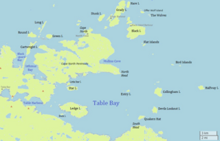
Table Bay is a natural bay and former community on the coast of Labrador in the province of Newfoundland and Labrador, Canada. It drains into the Labrador Sea to the east.
Muddy Bay is a former settlement on the coast of Labrador in the province of Newfoundland and Labrador, Canada. It was located on the shore of Muddy Bay, a small bay of Favorite Tickle. Muddy Bay was deeply impacted by the 1918 Influenza Pandemic which resulted in the deaths of 21% of its total population of 320 at the time. The Labrador Public School opened by the Anglican Church in 1920 as part of the Canadian Indian residential school system was primarily occupied by orphaned children due to the casualties.

Mortier Bay is a natural bay on the Burin Peninsula on the south coast of the island of Newfoundland in the province of Newfoundland and Labrador, Canada. It is entered through a channel 1.5 miles (2.4 km) long and 0.5 miles (0.80 km)wide, at the north end of which the bay opens nearly 2 miles (3.2 km) in diameter with deep water and no anchorage, except in the harbors off it. The settlement of Marystown is located on the bay.
White Bear Bay is natural bay on the island of Newfoundland in the province of Newfoundland and Labrador, Canada. The Ramea islands are south of the bay. The bay is filled with fjords, valleys and massive waterfalls which makes it a well known tourist spot. Many people own cabins in the bay to temporarily live there.
Sandy Bay is a natural bay off the island of Newfoundland in the province of Newfoundland and Labrador, Canada.
Shoal Bay is a natural bay off the island of Newfoundland in the province of Newfoundland and Labrador, Canada.
Deadman's Bay is a natural bay off the island of Newfoundland in the province of Newfoundland and Labrador, Canada.
Goose Bay is a natural bay off the island of Newfoundland in the province of Newfoundland and Labrador, Canada.
Blackhead Bay is a natural bay off the island of Newfoundland in the province of Newfoundland and Labrador, Canada. It is a side bay of Bonavista Bay.
Robinhood Bay is a natural bay off the island of Newfoundland in the province of Newfoundland and Labrador, Canada. It cuts into the southern shore of Bonavista Peninsula and opens into Trinity Bay. The town of Port Rexton is situated at the north end of the bay.

Spaniard's Bay is a natural bay off the island of Newfoundland in the province of Newfoundland and Labrador, Canada. It extends from Conception Bay into the northern section of the Avalon Peninsula.

Mobile Bay is a natural bay off the island of Newfoundland in the province of Newfoundland and Labrador, Canada. It is on the eastern shore of the Avalon Peninsula.
Caplin Bay is a natural bay on the coast of Labrador in the province of Newfoundland and Labrador, Canada.
Scrammy Bay is a natural bay on the coast of Labrador in the province of Newfoundland and Labrador, Canada. It is in the southeast reaches of St. Mary’s Bay to the east of lavander’s Arm.
Partridge Bay is a natural bay on the coast of Labrador in the province of Newfoundland and Labrador, Canada. It lies to the north of Rocky Bay and to the south of Shoal Bay, with several small uninhabited islands across its entrance from the Labrador Sea.
Sandwich Bay is a natural bay on the coast of Labrador in the province of Newfoundland and Labrador, Canada. The principal permanent settlement is Cartwright, located at the south entrance to the inner part of the bay. Other settlements along the bay include Paradise River and North River. Both of these communities are located at the outlets of the rivers of the same name into the bay. There is a road following the entire eastern coastline of Sandwich Bay, Newfoundland and Labrador Route 516.
Division No. 1, Subdivision L is an unorganized subdivision on the Avalon Peninsula in Newfoundland and Labrador, Canada. It is in Division 1 and contains the unincorporated communities of Bareneed, Black Duck Pond, Blow Me Down, Coley's Point South, Hibb's Cove, Pick Eyes, Port de Grave, Ship Cove and The Dock
References
- ↑ United States Hydrographic Office; Davenport, Richard G. (1884). Newfoundland and Labrador: The coast and banks of Newfoundland and the coast of Labrador, from Grand Point to the Koksoak River, with the adjacent islands and banks (Public domain ed.). Govt. print. off. pp. 505–. Retrieved 20 November 2011.
53°18′58″N55°49′52″W / 53.316°N 55.831°W
| | This Labrador location article is a stub. You can help Wikipedia by expanding it. |