
Cutler Bay is an incorporated town in Miami-Dade County, Florida established in 2005, with a population of approximately 43,718 as of 2019.

Homestead is a city within Miami-Dade County in the U.S. state of Florida, between Biscayne National Park to the east and Everglades National Park to the west. Homestead is primarily a Miami suburb and a major agricultural area. It is a principal city of the Miami metropolitan area, which was home to an estimated 6,012,331 people at the 2015 census.

Key Biscayne is an island town in Miami-Dade County, Florida, United States. The population was 12,344 at the 2010 census.

North Miami is a suburban city located in northeast Miami-Dade County, Florida, United States, about 10 miles (16 km) north of Miami. The city lies on Biscayne Bay and hosts the Biscayne Bay Campus of Florida International University, and the North Miami campus of Johnson & Wales University. Originally the town of "Arch Creek", the area was incorporated as the "Town of Miami Shores", which was renamed the "Town of North Miami" in 1931. It was reincorporated as a city in 1953.

Coconut Grove, also known colloquially as The Grove, is the oldest continuously inhabited neighborhood of Miami in Miami-Dade County, Florida, United States. The neighborhood is roughly bound by North Prospect Drive to the south, LeJeune Road to the west, South Dixie Highway and Rickenbacker Causeway to the north, and Biscayne Bay to the east. It is south of the neighborhoods of Brickell and The Roads and east of Coral Gables. The neighborhood's name has been sometimes spelled "Cocoanut Grove" but the definitive spelling "Coconut Grove" was established when the city was incorporated in 1919.

Biscayne National Park is an American national park in southern Florida, south of Miami. The park preserves Biscayne Bay and its offshore barrier reefs. Ninety-five percent of the park is water, and the shore of the bay is the location of an extensive mangrove forest. The park covers 172,971 acres and includes Elliott Key, the park's largest island and northernmost of the true Florida Keys, formed from fossilized coral reef. The islands farther north in the park are transitional islands of coral and sand. The offshore portion of the park includes the northernmost region of the Florida Reef, one of the largest coral reefs in the world.

Biscayne Bay is a lagoon that is approximately 35 miles (56 km) long and up to 8 miles (13 km) wide located on the Atlantic coast of South Florida, United States. It is usually divided for purposes of discussion and analysis into three parts: North Bay, Central Bay, and South Bay. Its area is 428 square miles (1,110 km2). The drainage basin covers 938 square miles (2,430 km2).

Virginia Key is an 863-acre (3.49 km2) barrier island in Miami, Florida, United States in Biscayne Bay, south of Brickell and north of Key Biscayne. It is accessible from the mainland via the Rickenbacker Causeway.

The Venetian Causeway crosses Biscayne Bay between Miami on the mainland and Miami Beach on a barrier island in south Florida. The man-made Venetian Islands and non-bridge portions of the causeway were created by materials which came from the dredging of the bay. The Venetian Causeway follows the original route of the Collins Bridge, a wooden 2.5 mi (4 km) long structure built in 1913 by John S. Collins and Carl G. Fisher which opened up the barrier island for unprecedented growth and development.

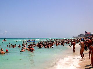
Baker's Haulover Inlet is a man-made channel in Miami-Dade County, Florida connecting the northern end of Biscayne Bay with the Atlantic Ocean, at coordinates 25°53′59″N80°07′26″W. The inlet was cut in 1925 through a narrow point in the sand between the cities of Bal Harbour and Sunny Isles. It is the location of an official nude beach, recreation areas and marina in the 99-acre Haulover Park. A fixed bridge carries SR A1A across the inlet.
From the late 1950s to the 1970s, State Road 908 was a 13-mile-long east–west street in southern Miami-Dade County, Florida, USA. Locally, it was known as Southwest 232nd Street, Silver Palm Drive, and Bailes Road. Its western terminus was an intersection with Country Club Road in the Redlands; its eastern terminus was an intersection with Galloway Road midway between Cutler Bay and Black Point. All but 1.3 miles (2.1 km) of SR 908 was on Silver Palm Drive—the section just east of South Dixie Highway was bypassed by using US 1 and Bailes Drive in Goulds.

Elliott Key is the northernmost of the true Florida Keys, and the largest key north of Key Largo. It is located entirely within Biscayne National Park, in Miami-Dade County, Florida, east of Homestead, Florida. It is bordered by the Atlantic Ocean to the east, Biscayne Bay to the west, Sands Key to the north and Old Rhodes Key to the south. Adams Key is just west of the southern end of Elliott Key. Elliott Key is about seven miles (11 km) long. Its maximum width is about 2,500 feet (760 m) near the north end and its average width is less than 2,000 feet (610 m). The higher elevations on the island range from 6 to 8 feet above sea level and occur generally along an unimproved road that runs longitudinally through the center of the island. The average elevation is about 3 feet (0.91 m) above sea level. The key is accessible only by boat. Elliott Key has a National Park Service campground, but is otherwise uninhabited.

Charles Deering Estate was the Florida home of Charles Deering until 1927 when he died at the estate.

Crandon Park is a 808-acre (3.27 km2) urban park in metropolitan Miami, occupying the northern part of Key Biscayne. It is connected to mainland Miami via the Rickenbacker Causeway.

Old Cutler Road is an off-grid plan, 14.9-mile (24.0 km) main northeast–southwest road running south of downtown Miami in Miami-Dade County, Florida, United States.
Haulover Park is a 177-acre (72 ha) urban park owned and operated by Miami-Dade County Parks, Recreation & Open Spaces Department, located in metropolitan Miami, just north of Bal Harbour, Florida. The park is located on a shoal between the Atlantic Ocean and Biscayne Bay, just north of the Broad Causeway and Collins Avenue.

Miami-Dade County is located in the southeastern part of the U.S. state of Florida. According to a 2019 census report, the county had a population of 2,716,940, making it the most populous county in Florida and the seventh-most populous county in the United States. It is also Florida's third largest county in terms of land area, with 1,946 square miles (5,040 km2). The county seat is Miami, the principal city in South Florida.

Matheson Hammock Park is a 630 acres (2.5 km2) urban park in metropolitan Miami at 9610 Old Cutler Road, just south of Coral Gables, Florida. The park surrounds the north and western ends of Fairchild Tropical Botanic Garden.
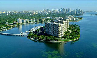
Grove Isle is a 20-acre (81,000 m2) island lying off the north-east coast of Miami's Coconut Grove neighborhood. Three waterfront hi-rise residences have been built on the island which were master-planned to include a resort hotel, restaurants, marina, club amenities and services.

