
In the construction industry, black rocks that share the hardness and strength of granitic rocks are known as black granite. In geological terms, black granite might be gabbro, diabase, basalt, diorite, norite, or anorthosite. [1]
In the construction industry, black rocks that share the hardness and strength of granitic rocks are known as black granite. In geological terms, black granite might be gabbro, diabase, basalt, diorite, norite, or anorthosite. [1]
In geology, felsic is a modifier describing igneous rocks that are relatively rich in elements that form feldspar and quartz. It is contrasted with mafic rocks, which are richer in magnesium and iron. Felsic refers to silicate minerals, magma, and rocks which are enriched in the lighter elements such as silicon, oxygen, aluminium, sodium, and potassium. Molten felsic magma and lava is more viscous than molten mafic magma and lava. Felsic magmas and lavas have lower temperatures of melting and solidification than mafic magmas and lavas.

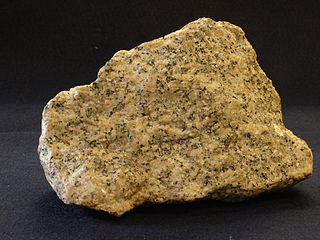
Granite is a coarse-grained (phaneritic) intrusive igneous rock composed mostly of quartz, alkali feldspar, and plagioclase. It forms from magma with a high content of silica and alkali metal oxides that slowly cools and solidifies underground. It is common in the continental crust of Earth, where it is found in igneous intrusions. These range in size from dikes only a few centimeters across to batholiths exposed over hundreds of square kilometers.
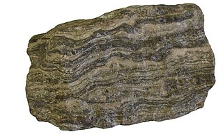
Gneiss is a common and widely distributed type of metamorphic rock. It is formed by high-temperature and high-pressure metamorphic processes acting on formations composed of igneous or sedimentary rocks. This rock is formed under pressures ranging from 2 to 15 kbar, sometimes even more, and temperatures over 300 °C (572 °F). Gneiss nearly always shows a banded texture characterized by alternating darker and lighter colored bands and without a distinct cleavage.

A pegmatite is an igneous rock showing a very coarse texture, with large interlocking crystals usually greater in size than 1 cm (0.4 in) and sometimes greater than 1 meter (3 ft). Most pegmatites are composed of quartz, feldspar, and mica, having a similar silicic composition to granite. However, rarer intermediate composition and mafic pegmatites are known.
The Llano Uplift is a geologically ancient, low geologic dome that is about 90 miles (140 km) in diameter and located mostly in Llano, Mason, San Saba, Gillespie, and Blanco counties, Texas. It consists of an island-like exposure of Precambrian igneous and metamorphic rocks surrounded by outcrops of Paleozoic and Cretaceous sedimentary strata. At their widest, the exposed Precambrian rocks extend about 65 miles (105 km) westward from the valley of the Colorado River and beneath a broad, gentle topographic basin drained by the Llano River. The subdued topographic basin is underlain by Precambrian rocks and bordered by a discontinuous rim of flat-topped hills. These hills are the dissected edge of the Edwards Plateau, which consist of overlying Cretaceous sedimentary strata. Within this basin and along its margin are down-faulted blocks and erosional remnants of Paleozoic strata which form prominent hills.

The St. Francois Mountains in southeast Missouri are a mountain range of Precambrian igneous mountains rising over the Ozark Plateau. This range is one of the oldest exposures of igneous rock in North America. The name of the range is spelled out as Saint Francois Mountains in official GNIS sources, but it is sometimes misspelled in use as St. Francis Mountains to match the anglicized pronunciation of both the range and St. Francois County.
A granitoid is a generic term for a diverse category of coarse-grained igneous rocks that consist predominantly of quartz, plagioclase, and alkali feldspar. Granitoids range from plagioclase-rich tonalites to alkali-rich syenites and from quartz-poor monzonites to quartz-rich quartzolites. As only two of the three defining mineral groups need to be present for the rock to be called a granitoid, foid-bearing rocks, which predominantly contain feldspars but no quartz, are also granitoids. The terms granite and granitic rock are often used interchangeably for granitoids; however, granite is just one particular type of granitoid.

The Wichita Mountains are located in the southwestern portion of the U.S. state of Oklahoma. It is the principal relief system in the Southern Oklahoma Aulacogen, being the result of a failed continental rift. The mountains are a northwest-southeast trending series of rocky promontories, many capped by 500 million-year old granite. These were exposed and rounded by weathering during the Pennsylvanian and Permian Periods. The eastern end of the mountains offers 1,000 feet (305 m) of topographic relief in a region otherwise dominated by gently rolling grasslands.
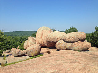
Elephant Rocks State Park is a geologic reserve and public recreation area encompassing an outcropping of Precambrian granite in the Saint Francois Mountains in the U.S. state of Missouri. The state park is named for a string of large granite boulders which resemble a train of pink circus elephants. The park was created following the donation of the land to the state in 1967 by geologist Dr. John Stafford Brown. The park is used for picnicking, rock climbing, and trail exploration. It is managed by the Missouri Department of Natural Resources.
Quartz Mountain is located in Greer County in southwest Oklahoma. It is the namesake of Quartz Mountain Nature Park and the park boundaries enclose its eastern flank. It is near the cities of Mangum, Oklahoma and Altus, Oklahoma. The park is open to the public year-round for rock climbing, hiking, boating, camping, nature observation and photography, and environmental education and interpretation. The mountain overlooks scenic Lake Altus-Lugert.
Prindle Volcano is an isolated basaltic cinder cone located in eastern Alaska, United States, in the headwaters of the East Fork of the Fortymile River, approximately 80 kilometers northeast of Tok, Alaska. The cone is fresh-looking and has a base approximately 900 metres wide. It is the northwesternmost expression of the Northern Cordilleran Volcanic Province. The cinder cone, and an approximately 11-kilometre (6.8-mile) long lava flow which breached the margin of the cone, erupted in the Pleistocene approximately 176,000 years ago. The lava flow extends to the southeast, then turns southwest and continues in a river valley.

Granite Mountain is a 7,628-foot (2,325 m) mountain located in Yavapai County, Arizona that covers roughly 12 square miles (31 km2). It was once known as Mount Gurley, for the first governor of the Arizona Territory, John A. Gurley. Its southwest face has a sheer granite cliff approximately 500 feet high that is one of the best locations for rock climbing in the state of Arizona. It is located in the Granite Mountain Wilderness, which is managed as a part of the Prescott National Forest. The mountain stands at the northern end of the Sierra Prietas, and borders Skull Valley on the west, on the northwest by the Santa Maria Mountains, and east by the Williamson Valley.
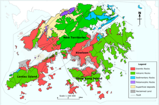
The geology of Hong Kong is dominated by igneous rocks formed during a major volcanic eruption period in the Mesozoic era. It made up 85% of Hong Kong's land surface and the remaining 15% are mostly sedimentary rocks located in the northeast New Territories. There are also a very small percentage of metamorphic rocks in the New Territories, formed by deformation of pre-existing sedimentary rocks (metamorphism).

Igneous rock, or magmatic rock, is one of the three main rock types, the others being sedimentary and metamorphic. Igneous rocks are formed through the cooling and solidification of magma or lava.
Igneous rocks are found in Bukit Timah, Woodlands, and Pulau Ubin island. Granite makes up the bulk of the igneous rock. Gabbro is also found in the area and is found in an area called Little Guilin, named for its resemblance to Guilin in South China. This area is in Bukit Gombak. Sedimentary rocks are found on the western part of Singapore, which is mainly made of sandstone and mudstones. It also includes the southwestern area. Metamorphic rocks are found in the northeastern part of Singapore, and also on Pulau Tekong, off the east coast of Singapore. The rocks are mainly made up of quartzite, and also make up the Sajahat Formation.

The geology of Massachusetts includes numerous units of volcanic, intrusive igneous, metamorphic and sedimentary rocks formed within the last 1.2 billion years. The oldest formations are gneiss rocks in the Berkshires, which were metamorphosed from older rocks during the Proterozoic Grenville orogeny as the proto-North American continent Laurentia collided against proto-South America. Throughout the Paleozoic, overlapping the rapid diversification of multi-cellular life, a series of six island arcs collided with the Laurentian continental margin. Also termed continental terranes, these sections of continental rock typically formed offshore or onshore of the proto-African continent Gondwana and in many cases had experienced volcanic events and faulting before joining the Laurentian continent. These sequential collisions metamorphosed new rocks from sediments, created uplands and faults and resulted in widespread volcanic activity. Simultaneously, the collisions raised the Appalachian Mountains to the height of the current day Himalayas.

Isis Temple is a prominence in the Grand Canyon, Arizona, Southwestern United States. It is located below the North Rim and adjacent to the Granite Gorge along the Colorado River. The Trinity Creek and canyon flow due south at its west border; its north, and northeast border/flank is formed by Phantom Creek and canyon, a west tributary of Bright Angel Creek; the creeks intersect about 3 mi (4.8 km) southeast, and 1.0 mi (1.6 km) north of Granite Gorge. The Isis Temple prominence, is only about 202 ft (62 m) lower than Grand Canyon Village, the main public center on Grand Canyon’s South Rim.

The geology of the Isle of Skye in Scotland is highly varied and the island's landscape reflects changes in the underlying nature of the rocks. A wide range of rock types are exposed on the island, sedimentary, metamorphic and igneous, ranging in age from the Archaean through to the Quaternary.

The geology of Rhode Island is based on nearly one billion year old igneous crystalline basement rocks formed as part of the microcontinent Avalonia that collided with the supercontinent Gondwana. The region experienced substantial folding associated with its landlocked position during the Alleghanian orogeny mountain building event. The region accumulated sedimentary rocks, including small deposits of coal. The region was covered with thick Atlantic Coastal Plain sediments, with the erosion of the Appalachians and the creation of the Atlantic Ocean throughout the past 200 million years. These surficial sediments and soils were substantially reworked by the Pleistocene glaciations. The state's geology is part of the broader geology of New England.
The geology of Ukraine is the regional study of rocks, minerals, tectonics, natural resources and groundwater in Ukraine. The oldest rocks in the region are part of the Ukrainian Shield and formed more than 2.5 billion years ago in the Archean eon of the Precambrian. Extensive tectonic evolution and numerous orogeny mountain-building events fractured the crust into numerous block, horsts, grabens and depressions. Ukraine was intermittently flooded as the crust downwarped during much of the Paleozoic, Mesozoic and early Cenozoic, before the formation of the Alps and Carpathian Mountains defined much of its current topography and tectonics. Ukraine was impacted by the Pleistocene glaciations within the last several hundred thousand years. The country has numerous metal deposits as well as minerals, building stone and high-quality industrial sands.
| | This architecture-related article is a stub. You can help Wikipedia by expanding it. |