
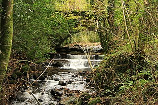
The Blackbrook River, also known as the Blackabrook River, is a tributary of the West Dart River on Dartmoor in Devon, England. [1] [2] [3]
The Blackbrook River, also known as the Blackabrook River, is a tributary of the West Dart River on Dartmoor in Devon, England. [1] [2] [3]
The river's source at Blackbrook Head in the Merrivale Range Danger Area just north of Black Dunghill, from which it flows south. As it crosses the moor, it soon leaves the Merrivale Range and is crossed by the B3357 road. It then flows to the east of Princetown before being crossed by the B3212 road. The river then heads east onto the moor again, where it meets the West Dart River from the right.

Dartmoor is an upland area in southern Devon, South West England. The moorland and surrounding land has been protected by National Park status since 1951. Dartmoor National Park covers 954 km2 (368 sq mi).

Postbridge is a hamlet in the heart of Dartmoor in the English county of Devon. It lies on the B3212, roughly midway between Princetown and Moretonhampstead.

The River Dart is a river in Devon, England, that rises high on Dartmoor and flows for 75 kilometres (47 mi) to the sea at Dartmouth.

The River Teign is a river in the county of Devon, England. It is 31 mi (50 km) long and rises on Dartmoor, becomes an estuary just below Newton Abbot and reaches the English Channel at Teignmouth.

Mid Devon is a local government district in Devon, England. The council is based in the district's largest town of Tiverton. The district also contains the towns of Bampton, Bradninch, Crediton and Cullompton, along with numerous villages and surrounding rural areas. Part of the district lies within the Blackdown Hills, an Area of Outstanding Natural Beauty.

Dartmeet is a popular tourist spot in the centre of Dartmoor, Devon, England at grid reference SX672731.

Belstone is a small village and civil parish in the West Devon District of Devon, England.
The Ashburn is a river in the Dartmoor moors in Devon in south-west England, flowing through the Ashburton valley to the River Dart.

The East Webburn is a stream in the Dartmoor moors in Devon in south-west England. It rises on the western side of the moors flowing off the west side of Hameldown ridge. Its source is less than 1 kilometre south west of Grimspound Bronze Age settlement. It flows south past Widecombe-in-the-Moor and joins the West Webburn River at Lizwell Meet in Oakmoor Wood. These combined streams then join the River Dart close to the village of Holne.

The River Swincombe is a right-bank tributary of the West Dart River that flows through Dartmoor national park in Devon, south-west England. It rises south-east of Princetown, and flows 2 km south-east to Foxtor Mires, where it turns north-east to meet the West Dart near Hexworthy. The first 2 km are known as the Strane River. Some maps show that the source starts north of Nakers Hill and heads north west to the east of Foxtor Mires where it meets the Strane River which is its own river.

The West Okement is a river in north Dartmoor in Devon in south-west England. It rises at West Okement Head near Cranmere Pool and flows in a generally NW direction past Black-a-Tor Copse and into Meldon Reservoir. After exiting the reservoir it flows in a generally northeast direction towards Okehampton, where it joins the East Okement River to form the River Okement. Its total length is roughly 13 miles (21 km). It is crossed by Meldon Viaduct.

The West Webburn is a stream on Dartmoor in Devon in south-west England. It rises on the eastern side of the moors flowing off the east side of Hameldown Ridge. Its source is extremely close to the Grimspound Bronze Age settlement, and it was probably the main source of water for the settlement. It flows south, going past Widecombe-in-the-Moor, and joins the East Webburn River at Lizwell Meet in Oakmoor Wood. These combined streams then join the River Dart at Buckland Bridge close to the village of Holne.
The West Dart River is one of the two main tributaries of the River Dart in Devon, England.

The A379 is a road in the English county of Devon. It links points on the edges of that county's two principal cities, Exeter and Plymouth, by an indirect and largely coastal route. The A38 provides a faster and more direct inland route between Exeter and Plymouth, whilst the A380 provides a similarly faster route between Exeter and the Torbay area. However the A379 serves many small coastal communities and ports along the coast. The indented nature of the South Devon coast means that the road is usually out of sight of the sea, but the many rivers and estuaries are crossed by bridges and, in one case, a cable ferry.

The Little Dart River is a tributary of the River Taw in Devon, England. It joins the Taw a mile west of Chulmleigh.

The River Ottery is a small river in northeast Cornwall, England, United Kingdom. The river is about twenty miles (32 km) long from its source southeast of Otterham to its confluence with the River Tamar at Nether Bridge, two miles (3.2 km) northeast of Launceston.

The River Sig is a 2.4 mile long river on Dartmoor in the county of Devon, England. It is a tributary to the River Lemon which it meets at Sigford.
Holne Ridge, on Dartmoor, includes some of southern Dartmoor's highest land. The ridge to the south west overlooks mires and bogs like Aune Head Mires. To the north east it overlooks the Dart Gorge with its many tors; Sharp Tor, for example. It also includes many notable features including:
50°33′02″N3°57′10″W / 50.5505°N 3.9528°W
| | This Devon location article is a stub. You can help Wikipedia by expanding it. |