
Bodmin Moor is a granite moorland in north-eastern Cornwall, England, United Kingdom. It is 208 square kilometres (80 sq mi) in size, and dates from the Carboniferous period of geological history. It includes Brown Willy, the highest point in Cornwall, and Rough Tor, a slightly lower peak. Many of Cornwall's rivers have their sources here. It has been inhabited since at least the Neolithic era, when early farmers started clearing trees and farming the land. They left their megalithic monuments, hut circles and cairns, and the Bronze Age culture that followed left further cairns, and more stone circles and stone rows. By medieval and modern times, nearly all the forest was gone and livestock rearing predominated.

Childe's Tomb is a granite cross on Dartmoor, Devon, England. Although not in its original form, it is more elaborate than most of the crosses on Dartmoor, being raised upon a constructed base, and it is known that a kistvaen is underneath.

Dartmoor is an upland area in southern Devon, South West England. The moorland and surrounding land has been protected by National Park status since 1951. Dartmoor National Park covers 954 km2 (368 sq mi).

Dartmoor Preservation Association (DPA) is one of the oldest environmental or amenity bodies in the UK. It was founded in 1883. It concerns itself with Dartmoor, a National Park in Devon, south-west England. It began with two main areas of concern. Firstly, commoners' rights were being eroded through army use, including the firing of live artillery shells, and piecemeal enclosure of land around the margins. Secondly, there was increasing public interest in Dartmoor's scenery, archaeology, history and wildlife

The industrial archaeology of Dartmoor covers a number of the industries which have, over the ages, taken place on Dartmoor, and the remaining evidence surrounding them. Currently only three industries are economically significant, yet all three will inevitably leave their own traces on the moor: china clay mining, farming and tourism.
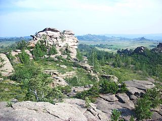
A tor, which is also known by geomorphologists as either a castle koppie or kopje, is a large, free-standing rock outcrop that rises abruptly from the surrounding smooth and gentle slopes of a rounded hill summit or ridge crest. In the South West of England, the term is commonly also used for the hills themselves – particularly the high points of Dartmoor in Devon and Bodmin Moor in Cornwall.

The Tamar is a river in south west England that forms most of the border between Devon and Cornwall. A large part of the valley of the Tamar is protected as the Tamar Valley National Landscape, and some is included in the Cornwall and West Devon Mining Landscape due to its historic mining activities.

River Walkham is a river whose source is on Dartmoor, Devon, England.
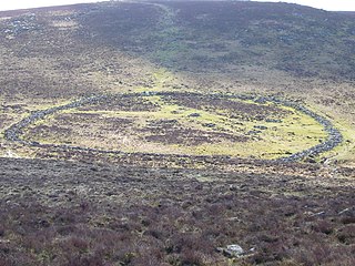
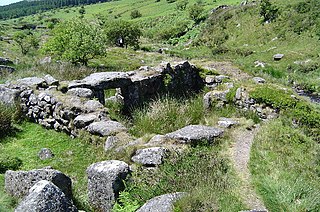
Grimspound is a late Bronze Age settlement, situated on Dartmoor in Devon, England. It consists of a set of 24 hut circles surrounded by a low stone wall. The name was first recorded by the Reverend Richard Polwhele in 1797; it was probably derived from the Anglo-Saxon god of war, Grim.

The Dartmoor longhouse is a type of traditional stone-built home, typically found on the high ground of Dartmoor, in Devon, England and belonging to a wider tradition of combining human residences with those of livestock under a single roof specific to western Britain; Wales, Cornwall and Devon, where they are more usually referred to simply as longhouses and in general housebarns.
The tin mining industry on Dartmoor, Devon, England, is thought to have originated in pre-Roman times, and continued right through to the 20th century, when the last commercially worked mine closed in November 1930. From the 12th century onwards tin mining was regulated by a stannary parliament which had its own laws.

Mining in Cornwall and Devon, in the southwest of Britain, is thought to have begun in the early-middle Bronze Age with the exploitation of cassiterite. Tin, and later copper, were the most commonly extracted metals. Some tin mining continued long after the mining of other metals had become unprofitable, but ended in the late 20th century. In 2021, it was announced that a new mine was extracting battery-grade lithium carbonate, more than 20 years after the closure of the last South Crofty tin mine in Cornwall in 1998.
A blowing house or blowing mill was a building used for smelting tin in Cornwall and on Dartmoor in Devon, in South West England. Blowing houses contained a furnace and a pair of bellows that were powered by an adjacent water wheel, and they were in use from the early 14th century until they were gradually replaced by reverberatory furnaces in the 18th century. The remains of over 40 blowing houses have been identified on Dartmoor.

Whiteworks is a former mining hamlet near the town of Princetown, within Dartmoor National Park, in the English county of Devon. Tin mining is central to the history of settlement at Whiteworks, which was once home to one of Dartmoor's largest tin mines. The original cottages and their inhabitants were related to this industry, until the area became used increasingly for farming in the 20th century. The site has now largely been abandoned, although Whiteworks is still on the route of many walks including Abbots Way Walk passes 500 m to the west.

Dartmoor kistvaens are burial tombs or cists from the late Neolithic and early Bronze Age, i.e. from c. 2500 BC to c. 1500 BC. Kistvaens have been found in many places, including Dartmoor, a 954 km2 area of moorland in south Devon, England. The box-like stone tombs were created when the ancient people of the area lived in hut circles. Cists are often to be found in the centre of a cairn circle although some appear solitary which could be the result of the loss of an original slight mound. There are over 180 known cists on Dartmoor although there could be up to 100 that remain buried underneath unexplored cairns. In the South West there are no cists to be found on the Quantock Hills, only 2 to be found on Exmoor and 58 to be found on Bodmin Moor. The Dartmoor cists are unique in that about 94% have the longer axis of the tomb orientated in a NW/SE direction It appears that Dartmoor cists were positioned in such a way that the deceased were facing the Sun.

Walkhampton is a village and civil parish on the western side of Dartmoor in the county of Devon, England. The village lies on the Black Brook, a tributary of the River Walkham, about 7 kilometres (4.3 mi) south-east of Tavistock, near the villages of Horrabridge, Yelverton and Dousland. Burrator Reservoir, constructed in 1898, is to the south-east.

A reave is a long and generally straight boundary wall made of stone that was built during the Bronze Age. Reaves were identified as prehistoric features on Dartmoor in Devon, England in 1972, and although they had been described by antiquarians in the 1820s, the knowledge of their origins had been lost, ignored and misrepresented for around 150 years.

Cosdon Hill, also called Cosdon Beacon, or Cawsand Beacon, is one of the highest hills on Dartmoor, in Devon, England. It has numerous traces of prehistoric occupation.
This article describes the geology of Dartmoor National Park in Devon, in south-west England. Dartmoor gained national park status in 1951 but the designated area of 954 km2 (368 sq mi) extends beyond the upland of Dartmoor itself to include much of the surrounding land, particularly in the northeast. The geology of the national park consists of a 625 km2 (241 sq mi) core of granite intruded during the early Permian period into a sequence of sedimentary rocks originating in the Devonian and Carboniferous periods. These rocks were faulted and folded, sometimes, intensely, during the Variscan orogeny. Thermal metamorphism has also taken place around the margins of the granite pluton altering the character of the sedimentary rocks whilst mineral veins were emplaced within the granite. A small outlier of Palaeogene sediments occurs on the eastern boundary of the national park.


