
Dartmoor is an upland area in southern Devon, England. The moorland and surrounding land has been protected by National Park status since 1951. Dartmoor National Park covers 954 km2 (368 sq mi).

Dartmoor Preservation Association (DPA) is one of the oldest environmental or amenity bodies in the UK. It was founded in 1883. It concerns itself with Dartmoor, a National Park in Devon, south-west England. It began with two main areas of concern. Firstly, commoners' rights were being eroded through army use, including the firing of live artillery shells, and piecemeal enclosure of land around the margins. Secondly, there was increasing public interest in Dartmoor's scenery, archaeology, history and wildlife

South Hams is a local government district on the south coast of Devon, England. Services divide between those provided by its own Council headquartered in Totnes, and those provided by Devon County Council headquartered in the city of Exeter.
Merrivale is a locality in western Dartmoor, in the West Devon district of Devon, England. It is best known for the nearby series of Bronze Age megalithic monuments to the south and a former granite quarry.

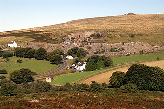
Dartmeet is a popular tourist spot in the centre of Dartmoor, Devon, England at grid reference SX672731.
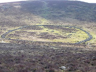
Grimspound is a late Bronze Age settlement, situated on Dartmoor in Devon, England. It consists of a set of 24 hut circles surrounded by a low stone wall. The name was first recorded by the Reverend Richard Polwhele in 1797; it was probably derived from the Anglo-Saxon god of war, Grim.
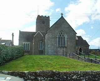
Holne is a village and civil parish on the southeastern slopes of Dartmoor in Devon, England. A community has existed here since at least the 11th century, and today a population of around 250 people is served by a church and a public house, the Church House Inn.

The Dartmoor longhouse is a type of traditional stone-built home, typically found on the high ground of Dartmoor, in Devon, England and belonging to a wider tradition of combining human residences with those of livestock under a single roof specific to western Britain; Wales, Cornwall and Devon, where they are more usually referred to simply as longhouses and in general housebarns.

Hound Tor is a tor on Dartmoor, Devon, England and is a good example of a heavily weathered granite outcrop. It is easily accessible, situated within a few minutes from the B3387 between Bovey Tracey and Widecombe-in-the-Moor.

The Erme is a river in south Devon, England. From its source on Dartmoor it flows in a generally southerly direction past some of the best-preserved archaeological remains on the moor. It leaves the moor at the town of Ivybridge and continues southward, passing the settlements of Ermington, Modbury and Holbeton. Near Holbeton it becomes a ria and empties into the English Channel in Bigbury Bay, between the rivers Yealm and Avon.

The Dartmoor National Park Authority (DNPA) is a national park authority in England, legally responsible for Dartmoor in Devon. It came into existence in its present form in 1997, being preceded by a committee of Devon County Council and the Dartmoor National Park Committee from 1 April 1974.

Two Bridges is an isolated location on the river West Dart in the heart of Dartmoor National Park in Devon, England. It is situated around 2.5 km (1.6 mi) northeast of Princetown at the intersection of the two roads that cross Dartmoor: one is the old turnpike road which was built across Dartmoor in the late 18th century ; the other is the B3357.
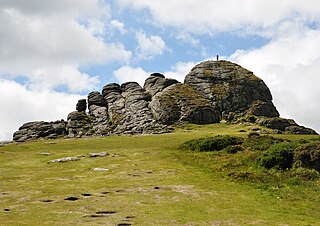
Haytor, also known as Haytor Rocks, Hay Tor, or occasionally Hey Tor, is a granite tor on the eastern edge of Dartmoor in the English county of Devon.
The West Dart River is one of the two main tributaries of the River Dart in Devon, England.

Whiteworks is a former mining hamlet near the town of Princetown, within Dartmoor National Park, in the English county of Devon. Tin mining is central to the history of settlement at Whiteworks, which was once home to one of Dartmoor's largest tin mines. The original cottages and their inhabitants were related to this industry, until the area became used increasingly for farming in the 20th century. The site has now largely been abandoned, although Whiteworks is still on the route of many walks including Abbots Way Walk passes 500 m to the west.

Bellever is a hamlet in Dartmoor, Devon, England. It is located on the river East Dart about 2 kilometres (1 mi) south of Postbridge.

Wistman's Wood is one of three remote high-altitude oakwoods on Dartmoor in Devon, England.

Dartmoor kistvaens are burial tombs or cists from the late Neolithic and early Bronze Age, i.e. from c 2500 BC to c 1500 BC. Kistvaens have been found in many places, including Dartmoor, a 954 km2 area of moorland in south Devon, England. The box-like stone tombs were created when the ancient people of the area lived in hut circles. Cists are often to be found in the centre of a cairn circle although some appear solitary which could be the result of the loss of an original slight mound. There are over 180 known cists on Dartmoor although there could be up to 100 that remain buried underneath unexplored cairns. In the South West there are no cists to be found on the Quantock Hills, only 2 to be found on Exmoor and 58 to be found on Bodmin Moor. The Dartmoor cists are unique in that about 94% have the longer axis of the tomb orientated in a NW/SE direction It appears that Dartmoor cists were positioned in such a way that the deceased were facing the sun.

Cosdon Hill, also called Cosdon Beacon, or Cawsand Beacon, is one of the highest hills on Dartmoor, in Devon, England. It has numerous traces of prehistoric occupation.
Richard Hansford Worth of Plymouth, Devon was a civil engineer, geologist, archaeologist and writer on Dartmoor. He was the author of numerous papers published by the Devonshire Association some of which became the basis of the book Worth’s Dartmoor published posthumously.
