
Belize is a country on the north-eastern coast of Central America. It is bordered by Mexico to the north, the Caribbean Sea to the east, and Guatemala to the west and south. It also shares a water boundary with Honduras to the southeast. It has an area of 22,970 square kilometres (8,867 sq mi) and a population of 441,471 (2022). Its mainland is about 290 km (180 mi) long and 110 km (68 mi) wide. It is the least populated and least densely populated country in Central America. Its population growth rate of 1.87% per year is the second-highest in the region and one of the highest in the Western Hemisphere. Its capital is Belmopan, and its largest city is the namesake city of Belize City. Belize is often thought of as a Caribbean country in Central America because it has a history similar to that of English-speaking Caribbean nations. Belize's institutions and official language reflect its history as a British colony.

Politics of Belize takes place in a framework of a parliamentary representative democratic monarchy, whereby King Charles III serves as head of state and the prime minister is the head of government, and of a multi-party system. Executive power is exercised by the government. Legislative power is vested in both the government and the Parliament of Belize.

Toledo District is the southernmost and least populated district in Belize. Punta Gorda is the District capital. According to the Human Development Index (HDI), it is the second most developed region in the country. The district has a diverse topography which features rainforests, extensive cave networks, coastal lowland plains, and offshore cays. Toledo is home to a wide range of cultures such as Mopan, Kekchi Maya, Creole, Garifuna, East Indians, Mennonites, Mestizos, and descendants of US Confederate settlers.
Belize District is a district of the nation of Belize. Its capital is Belize City.
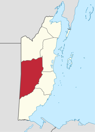
Cayo District is a district located in the west part of Belize. It is the most extensive, second-most populous and third-most densely populated of the six districts of Belize. The district's capital is the town of San Ignacio.
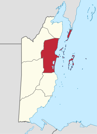
Belize is divided into six districts, those six are, from top to bottom, called Corozal, Orange Walk, Belize (District) Cayo, Stann Creek, and Toledo.
RFA Eddyfirth (A261) was an Eddy class coastal tanker of the Royal Fleet Auxiliary.

HMS Nubian was a Tribal-class frigate of the Royal Navy in service from 1962 and 1979. She was named after the Nubian ethnic group, located in Egypt and Sudan. She was sunk as a target in 1987.

Cahal Pech is a Maya site located near the town of San Ignacio in the Cayo District of Belize. The site was a palatial, hilltop home for an elite Maya family, and though the most major construction dates to the Classic period, evidence of continuous habitation has been dated to as far back as 1200 BCE during the Early Middle Formative period, making Cahal Pech one of the oldest recognizably Maya sites in Western Belize.

Cindy Blackman Santana, sometimes known as Cindy Blackman, is an American jazz and rock drummer. Blackman has recorded several jazz albums as a bandleader and has performed with Pharoah Sanders, Sonny Simmons, Ron Carter, Sam Rivers, Cassandra Wilson, Angela Bofill, Buckethead, Bill Laswell, Lenny Kravitz, Joe Henderson and Joss Stone.

The Pre-Columbian Belize history is the period from initial indigenous presence, across millennia, to the first contacts with Europeans - the Pre-Columbian or before Columbus period - that occurred on the region of the Yucatán Peninsula that is present day Belize.
His Majesty's Government in Belize, also referred to as the Belizean Government is the democratic administrative authority of Belize, a constitutional monarchy under a parliamentary democracy. It was formed in 1981 after gaining sovereignty from the United Kingdom. The constitution is the supreme law of Belize.

Cuello is a Maya archaeological site in northern Belize. The site is that of a farming village with a long occupational history. It was originally dated to 2000 BC, but these dates have now been corrected and updated to around 1200 BC. Its inhabitants lived in pole-and-thatch houses that were built on top of low plaster-coated platforms. The site contains residential groups clustered around central patios. It also features the remains of a steam bath dating to approximately 900 BC, making it the oldest steam bath found to date in the Maya lowlands. Human burials have been associated with the residential structures; the oldest have no surviving burial relics, but from 900 BC onwards, they were accompanied by offerings of ceramic vessels.
Local government in Belize consists of four types of local authorities: city councils, town councils, village councils and community councils. Some rural communities also have an alcalde, a local magistrate who performs both administrative and judicial functions.
Tapir Mountain Nature Reserve is a protected area in Belize, Central America. It falls under category (Ia) of the International Union for Conservation of Nature protected areas categories. It is managed by the Belize Forest Department and co-managed by the Belize Karst Habitat Conservation.
Lower Dover is a Maya archaeological site in the Belize River Valley. It is located on the grounds of the Lower Dover Field Station & Jungle Lodge, in Unitedville, Cayo District, Belize. The site is bordered by the Belize River to the north, Upper Barton Creek to the west, Lower Barton Creek to the east, and the Western Highway to the south. Lower Dover is one of several Maya archaeological sites in the area; it is across the Belize River from Barton Ramie, 3 kilometers west of Blackman Eddy, and 6 kilometers east of Baking Pot.
Eddy Blackman Stadion is a multi-purpose stadium in Livorno, Suriname. It is home to SVB Hoofdklasse club SCSV Takdier Boys and SVB Eerste Klasse outfits, SV Jai Hanuman and SCSV Kamal Dewaker.
The Preclassic or Formative Period of Belizean, Mayan, and Mesoamerican history began with the Mayan development of ceramics during 2000 BC – 900 BC, and ended with the advent of Mayan monumental inscriptions in 250 AD.
Franks Eddy is a village in the Cayo District of central interior Belize. The village is in an agricultural region with the most frequent crops being citrus and banana. It is one of 192 municipalities administrated at the village level in the country for census taking purposes. The village had a population of 378 in 2010. This represents roughly 0.6% of the district's total population. This was a 78% increase from 212 people recorded in the 2000 census.
