
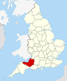
Wiltshire is a historic and ceremonial county in South West England with an area of 3,485 km2. It is landlocked and borders the counties of Dorset, Somerset, Hampshire, Gloucestershire, Oxfordshire and Berkshire. The county town was originally Wilton, after which the county is named, but Wiltshire Council is now based in the county town of Trowbridge. Within the county's boundary are two unitary authority areas, Wiltshire and Swindon, governed respectively by Wiltshire Council and Swindon Borough Council.

Shaftesbury is a town and civil parish in Dorset, England. It is situated on the A30 road, 20 miles west of Salisbury, near the border with Wiltshire. It is the only significant hilltop settlement in Dorset, being built about 215 metres above sea level on a greensand hill on the edge of Cranborne Chase.

The Blackmore Vale is a vale, or wide valley, in north Dorset, and to a lesser extent south Somerset and southwest Wiltshire in southern England.

The North Wessex Downs Area of Outstanding Natural Beauty (AONB) is located in the English counties of Berkshire, Hampshire, Oxfordshire and Wiltshire. The name North Wessex Downs is not a traditional one, the area covered being better known by various overlapping local names, including the Berkshire Downs, the North Hampshire Downs, the White Horse Hills, the Lambourn Downs, the Marlborough Downs, the Vale of Pewsey and Savernake Forest.
The Dorset Downs are an area of chalk downland in the centre of the county Dorset in south west England. The downs are the most western part of a larger chalk formation which also includes Cranborne Chase, Salisbury Plain, Hampshire Downs, Chiltern Hills, North Downs and South Downs.

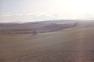
Cranborne Chase is a chalk plateau in central southern England, straddling the counties Dorset, Hampshire and Wiltshire. The plateau is part of the English Chalk Formation and is adjacent to Salisbury Plain and the West Wiltshire Downs in the north, and the Dorset Downs to the south west. The scarp slope of the hills faces the Blackmore Vale to the west, and to some extent the Vale of Wardour to the north. The chalk gently slopes south and dips under clays and gravels. The highest point is Win Green Down, in Wiltshire, at 910 feet (280 m).
The county of Somerset is in South West England, bordered by the Bristol Channel and the counties of Bristol and Gloucestershire to the north, and Wiltshire to the east, Dorset to the south, and Devon to the west. The climate, influenced by its proximity to the Atlantic Ocean and the prevailing westerly winds, tends to be mild, damp and windy.

Dorset is a county located in the middle of the south coast of England. It lies between the latitudes 50.512°N and 51.081°N and the longitudes 1.682°W and 2.958°W, and occupies an area of 2,653 km2. It spans 90 kilometres (56 mi) from east to west and 63 kilometres (39 mi) from north to south.

The Hampshire Downs form a large area of downland in central, southern England, mainly in the county of Hampshire. They are part of a belt of chalk downland that extends from the South Downs in the southeast, north to the Berkshire and Marlborough Downs, and west to the Dorset Downs.

The Dorset Heaths form an important area of heathland within the Poole Basin in southern England. Much of the area is protected.

The Weymouth Lowlands form a natural region on the south coast of England in the county of Dorset. Much of the area lies with the Dorset Area of Outstanding Natural Beauty.
The Natural Areas of England are regions, officially designated by Natural England, each with a characteristic association of wildlife and natural features. More formally, they are defined as "biogeographic zones which reflect the geological foundation, the natural systems and processes and the wildlife in different parts of England...".
A National Character Area (NCA) is a natural subdivision of England based on a combination of landscape, biodiversity, geodiversity and economic activity. There are 159 National Character Areas and they follow natural, rather than administrative, boundaries. They are defined by Natural England, the UK government's advisors on the natural environment.

The Marshwood and Powerstock Vales form a natural region in southwest England reaching to the Dorset coastline.

The Yeovil Scarplands are a natural region in southern England in the counties of Somerset and Dorset.

The Mid Severn Sandstone Plateau is a rural landscape and one of the natural regions of central England, straddling the border between the counties of Shropshire and Staffordshire. It stretches from the western fringes of the Birmingham conurbation to Telford in the north and Kidderminster in the south. The major feature of the plateau is the valley of the River Severn, which cuts through it from north to south. It consists of Permian and Triassic-age New Red Sandstone getting older as one goes west until one reaches Silurian and Carboniferous-age siltstones and coals west of the river.

The Vale of Taunton and Quantock Fringes form a natural region in the southwest of England in the county of Somerset. Natural England have designated the Vale of Taunton and Quantock Fringes as National Character Area 146.

The Vale of Wardour encompasses the valley of the River Nadder in the county of Wiltshire, England.
