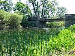
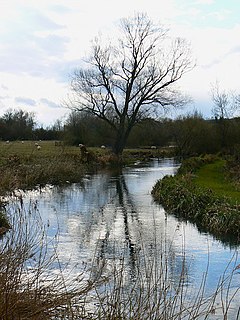
The River Lark is a river in England that crosses the border between Suffolk and Cambridgeshire. It is a tributary of the River Great Ouse, and was extended when that river was re-routed as part of drainage improvements. It is thought to have been used for navigation since Roman times, and improvements to its navigability were made in 1638 and in the early 18th century, when locks and staunches were built. The upper terminus was on the northern edge of Bury St Edmunds, but a new dock was opened near the railway station after the Eastern Union Railway opened its line in 1846.
The River Little Ouse is a river in the east of England, a tributary of the River Great Ouse. For much of its length it defines the boundary between Norfolk and Suffolk.

The River Douglas, also known as the River Asland or Astland, flows through parts of Lancashire and Greater Manchester in North West England. It is a tributary of the River Ribble and has several tributaries, the major ones being the River Tawd and the River Yarrow.

The River Goyt is a tributary of the River Mersey in North West England.
The Kennet is a tributary of the River Thames in Southern England. Most of the river is straddled by the North Wessex Downs AONB. The lower reaches have been made navigable as the Kennet Navigation, which – together with the Avon Navigation, the Kennet and Avon Canal and the Thames – links the cities of Bristol and London.

The River Dearne South Yorkshire, England flows roughly east for more than 30 kilometres (19 mi), from its source just inside West Yorkshire. It flows through Denby Dale, Clayton West, Darton, Barnsley, Darfield, Wath upon Dearne, Bolton on Dearne, Adwick upon Dearne and Mexborough to its confluence with the River Don at Denaby Main. Its main tributary is the River Dove, which joins it at Darfield. The river was one of those affected by the 2007 United Kingdom floods.
The River Stour is a 61 mi (98 km) river which flows through Wiltshire and Dorset in southern England, and drains into the English Channel. The catchment area for the river and its tributaries is listed as being 480 square miles (1,240 km2).
The River Meden is a river in Nottinghamshire, England. Its source lies just north of Huthwaite, near the Derbyshire border, and from there it flows north east through Pleasley and Warsop before merging temporarily with the River Maun near Bothamsall. The rivers divide after a short distance and go on separately to a point near Markham Moor where they once more combine to form the River Idle.

The River Ryton is a tributary of the River Idle. It rises close to the Chesterfield Canal near Kiveton Park, and is joined by a series of tributaries near Lindrick Common in the Metropolitan Borough of Rotherham, South Yorkshire, England. Most of its course is in Nottinghamshire, flowing through the town of Worksop. It meanders northwards to join the River Idle near the town of Bawtry on the South Yorkshire-Nottinghamshire border.

The River Clun runs mostly through Shropshire, England and joins the River Teme at Leintwardine, Herefordshire. The Clun Valley is part of the Shropshire Hills AONB.

The River Allen is a river in the county of Dorset in South West England. It flows for 14 miles (23 km) and has its confluence with the River Stour in Wimborne Minster. It has two main tributaries, the Gussage Stream and the Crichel Stream.

Foudry Brook is a small stream in southern England. It rises from a number of springs near the Hampshire village of Baughurst, and flows to the east and then the north, to join the River Kennet to the south of Reading. The upper section is called Silchester Brook, and beyond that, Bishop's Wood Stream. The underlying geology is chalk, covered by a layer of clay, and so it has the characteristics of a clay stream, experiencing rapid increases in level after heavy rain due to run-off from the surrounding land. It passes a number of listed buildings and scheduled monuments, including the site of the Roman town of Calleva Atrebatum or Silchester.

The River Perry is a river in Shropshire, England. It rises near Oswestry and flows south to meet the River Severn above Shrewsbury. Along its 24 miles (39 km) length, its level drops by some 320 feet (95 m). The channel has been heavily engineered, both to enable water mills to be powered by it, and to improve the drainage of the surrounding land. There were at least seven corn mills in the 1880s, and the last one remained operational until 1966. The middle section of the river crosses Baggy Moor, where major improvements were made in 1777 to drain the moor. The scheme was one of the largest to enclose and improve land in North Shropshire, and the quality of the reclaimed land justified the high cost. A section of the river bed was lowered in the 1980s, to continue the process.
The River Nadder is a tributary of the River Avon, flowing in south Wiltshire, England.

The Bow Brook is a substantial brook that flows for 28.8 miles (46.3 km) through Worcestershire, England. It is a lower tributary of the River Avon which it joins near Defford downstream of Eckington Bridge. Its principal tributaries include the Stoulton, Dean, and Seeley brooks.
The Badsey Brook, also known as the Broadway Brook, is a small brook that flows through Worcestershire, England. It is a lower tributary of the River Avon, which it joins near Offenham upstream of Evesham. Its principal tributary is the Bretforton Brook.
The Finham Brook is a lower tributary of the River Sowe, it flows through Kenilworth and Warwickshire, England, to join the Sowe near Finham. Its principal tributaries include the Canley Brook, which drains the Tile Hill and Canley areas of Coventry, and the Inchford Brook which rises near Beausale, and then flows in an arc through the parish of Beausale, Haseley, Honiley and Wroxall. The length of the Finham and Inchford brooks is 15 miles (24 km), which have a total catchment area of 71 square kilometres (27 sq mi).

Roe Beck also known as the River Roe in its lower reaches, is a beck that flows through Cumbria, England. It is a lower tributary of the River Caldew which it joins near Gaitsgill south of Dalston. The total length of the beck including Peel Gill is 20.8 kilometres (12.9 mi) and it has a catchment of 69 square kilometres (27 sq mi), which includes the area of its major tributary the River Ive.

Bedburn Beck is a 16.8 kilometres (10.4 mi) long, upper tributary of the River Wear in County Durham, England. The beck and its tributaries, including the Euden, Harthorpe and South Grain becks, have a catchment of 76 square kilometres (29 sq mi), much of which is covered by the coniferous Hamsterley Forest.

Caundle Brook is a 13.4 miles (21.6 km) tributary of the River Lydden that flows through Blackmore Vale in Dorset, England.