
Contra Costa County is a county located in the U.S. state of California, in the East Bay of the San Francisco Bay Area. As of the 2020 United States Census, the population was 1,165,927. The county seat is Martinez. It occupies the northern portion of the East Bay region of the San Francisco Bay Area and is primarily suburban. The county's name refers to its position on the other side of the bay from San Francisco. Contra Costa County is included in the San Francisco–Oakland–Berkeley, CA Metropolitan Statistical Area.

Scouting in California has a long history, from the 1910s to the present day, serving thousands of youth in programs related to their environments.

Piedmont is a small city located in Alameda County, California, United States, enclaved by the city of Oakland. Its residential population was 11,270 at the 2020 census. The name comes from the region of Piedmont in Italy, and it means 'foothill'. Piedmont was incorporated in 1907, and was developed significantly in the 1920s and 1930s.

The East Bay Regional Park District (EBRPD) is a special district operating in Alameda County and Contra Costa County, California, within the East Bay area of the San Francisco Bay Area. It maintains and operates a system of regional parks which is the largest urban regional park district in the United States. The administrative office is located in Oakland.

Claremont Canyon Regional Preserve is a small regional park mainly located in the city of Oakland, California, and administered by the East Bay Regional Park District. The park is named for the canyon in which it is situated, Claremont Canyon, out of which Claremont Creek flows on its way to its confluence with Temescal Creek. Previously the canyon was named Harwood's Canyon, and then later as Telegraph Canyon. The name was changed to Claremont by a developer of the nearby Claremont district.

Lake Merritt is a lake located in a large tidal lagoon basin in the center of Oakland, California, just east of Downtown. It is named after Samuel Merritt, Oakland's mayor in 1867–1869, who had the lagoon dammed turning the tidal lagoon into a salt water lake. It is surrounded by parkland and city neighborhoods. Historically significant as the first official wildlife refuge in the United States, designated in 1870, the lake has been listed as a National Historic Landmark since 1963. The circumference of the lake is 3.4 miles (5.5 km), with an area of 155 acres (63 ha).

Alum Rock Park, in the Alum Rock district of San Jose, California, is California's oldest municipal park, established in 1872 but serving as public land since the pueblo was established in 1777. Located in a valley in the Diablo Range foothills on the east side of San Jose, the 720 acre (2.9 km2) park offers 13 miles (21 km) of trails, varying from fairly level along Penitencia Creek to sharp switchbacks climbing to the ridges to the South Rim Trail and the North Rim Trail. The narrow floor of the valley includes a visitor center, a small museum/animal rehab facility, picnic areas, playgrounds, lawns, sand volleyball pits, mineral springs, lush plant life, woodlands, creek play opportunities, and occasional group camping.

Henry W. Coe State Park is a state park of California, United States, preserving a vast tract of the Diablo Range. The park is located closest to the city of Morgan Hill, and is located in both Santa Clara and Stanislaus counties. The park contains over 87,000 acres (35,000 ha), making it the largest state park in northern California, and the second-largest in the state. Managed within its boundaries is a designated wilderness area of about 22,000 acres (8,900 ha). This is officially known as the Henry W. Coe State Wilderness, but locally as the Orestimba Wilderness. The 89,164-acre (36,083 ha) park was established in 1959.
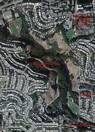
Glen Canyon Park is a city park in San Francisco, California. It occupies about 70 acres (28 ha) along a deep canyon adjacent to the Glen Park, Diamond Heights, and Miraloma Park neighborhoods. O'Shaughnessy Hollow is a rugged, undeveloped 3.6 acres (1.5 ha) tract of parkland that lies immediately to the west and may be considered an extension of Glen Canyon Park.

Montclair is a hillside neighborhood in Oakland, California, United States. Montclair is located along the western slope of the Oakland Hills from a valley formed by the Hayward Fault to the upper ridge of the hills.

The Forest of Nisene Marks State Park is a state park of California, United States, protecting a secondary forest in the watershed of Aptos Creek and Soquel Creek within the Santa Cruz Mountains. It is located outside Aptos, California, and contains over 40 miles (64 km) of hiking trails and fire roads through 10,223 acres (4,137 ha) of variable terrain.

Temescal is one of the oldest neighborhoods in Oakland, California, located in North Oakland, and centered on Telegraph Avenue. The neighborhood derives its name from Temescal Creek, a significant watercourse in the city.
India Basin is a neighborhood, named after the body of water, in the southeastern part of San Francisco, California, considered to be part of the larger Bayview–Hunters Point neighborhood.

Dr. Aurelia Reinhardt Redwood Regional Park is a part of the East Bay Regional Parks District (EBRPD) in the San Francisco Bay Area. It is located in the hills east of Oakland. The park contains the largest remaining natural stand of coast redwood found in the East Bay. The park is part of a historical belt of coast redwood extending south to Leona Canyon Regional Open Space Preserve and east to Moraga.

San Leandro Creek is a 21.7-mile-long (34.9 km) year-round natural stream in the hills above Oakland in Alameda County and Contra Costa County of the East Bay in northern California.

The history of Piedmont, California, covers the history of the area in California's San Francisco Bay Area that is now known as Piedmont, up to and beyond the legal establishment of a city.
Victory Boulevard is a major east–west arterial road that runs for 25 miles (40 km) traversing the entire length of the San Fernando Valley in Los Angeles County, California.
Arroyo Viejo is a westward flowing 5.1 miles (8.2 km) creek that begins in the Oakland Hills in Alameda County, California, and joins Lion Creek just before entering San Leandro Bay, a part of eastern San Francisco Bay.

