
Munda is the largest settlement on the island of New Georgia in the Western Province of Solomon Islands, and consists of a number of villages. It is located at the southwestern tip of the western end of New Georgia, and the large Roviana Lagoon is just offshore.

The New Georgia Islands are part of the Western Province of Solomon Islands. They are located to the northwest of Guadalcanal. The larger islands are mountainous and covered in rain forest. The main islands are New Georgia, Vella Lavella, Kolombangara, Ghizo, Vangunu, Rendova and Tetepare. They are surrounded by coral reefs and include the Marovo Lagoon.

USS Gwin (DD-433), a Gleaves-class destroyer, was the third ship of the United States Navy to be named for Lieutenant Commander William Gwin, an American Civil War officer who commanded river boats against Confederate forces in Alabama.

Kula Gulf is a waterway in the Western Province of the Solomon Islands. It lies between the islands of Kolombangara to the west, Arundel Island (Kohinggo) to the southwest, and New Georgia to the south and east. To the north, it opens into New Georgia Sound. To the southwest, it connects via Blackett Strait to Vella Gulf and the Solomon Sea.
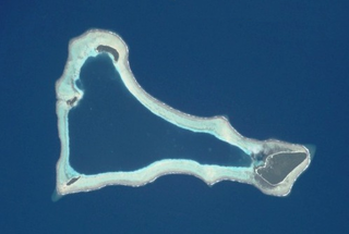
Sikaiana is a small atoll 212 kilometres NE of Malaita in Solomon Islands in the south Pacific Ocean. It is almost 14 kilometres in length and its lagoon, known as Te Moana, is totally enclosed by the coral reef. Its total land surface is only 2 square kilometres. There is no safe anchorage close to this atoll, which makes it often inaccessible to outsiders.

Choiseul Island, native name Lauru, is the largest island of the Choiseul Province, Solomon Islands, at 7.08°S 157°E. The administrative headquarters of Choiseul Province is situated in the town of Taro, on Taro Island.
Arundel Island is an island of the New Georgia Islands archipelago in the Western Province of Solomon Islands. Its indigenous names are Kohinggo and Ndokulu.
Lumbari Island is a small island off the north coast of Rendova Island in Western Province, Solomon Islands.

The Touo language, also known as Baniata (Mbaniata) or Lokuru, is spoken over the southern part of Rendova Island, located in the Western Province of the Solomon Islands.
Kiambe is a small island in the New Georgia Islands group of Western Province, Solomon Islands, located to the southeast of Munda.
Logha is a small island in the New Georgia Islands group of Western Province, Solomon Islands, located to the east of Ghizo Island. The estimated terrain elevation above sea level is some 28 metres.
Lola Island is an island within the Vona Vona Lagoon southeast of Vonavona Island in Western Province, Solomon Islands.

Uepi is an island in Western Province, in the independent nation of Solomon Islands. It is noted for its high quality blue-water drop-off scuba diving.
Vonavona is an island in Western Province, Solomon Islands. Alternative local names and spellings of the island are Parara and Wanawana. The estimated terrain elevation above sea level is some 21 metres (69 ft). Vonavona borders Ferguson Passage to the west, Arundel Island to the east, and the island of Kolombangara to the north.

Rob Roy Island, native name Velaviru, is an island in Solomon Islands located off the South East coast of Choiseul Island; it is located in Choiseul Province.
Sikopo is an island in Solomon Islands; part of the Arnarvon Islands in Isabel Province. It lies in Manning Strait, which is between Choiseul Island and Santa Isabel Island, and which connects New Georgia Sound to the Pacific. The strait is named for Captain Edward Manning, of Pitt, who was the first European to sail through the straits and chart it in 1792.
Alite Island is an island in Malaita Province, Solomon Islands. It is located off the west coast of Malaita Island. The estimated terrain elevation above sea level is 6 metres.
Seghe is a town on the island of New Georgia, Solomon Islands, an independent country in the Pacific Ocean.
US Naval Base Solomons was a number of United States Navy bases in the Solomon Islands in the Pacific Ocean. Most were built by the US Navy Seabees, Naval Construction Battalions, during World War II as part of the Pacific War. In August 1942 the United States Armed Forces took the Guadalcanal in the Solomon, in the Battle of Guadalcanal. US Navy Seabees built a new base at Guadalcanal, Naval Base Guadalcanal and then on other islands in the Solomons.

