Blato, Zagreb

Last updated

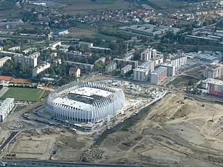
Blato is a neighborhood located in the Novi Zagreb - zapad city district of Zagreb, Croatia. It is spread along the Karlovačka Road, south of Jadranska Avenue. The population is 2,553 (2011). [1]

Zagreb Capital and largest city of Croatia

Zagreb is the capital and the largest city of Croatia. It is located in the northwest of the country, along the Sava river, at the southern slopes of the Medvednica mountain. Zagreb lies at an elevation of approximately 122 m (400 ft) above sea level. The estimated population of the city in 2018 is 810,003. The population of the Zagreb urban agglomeration is about 1.2 million, approximately a quarter of the total population of Croatia.

Croatia Republic in Central Europe

Croatia, officially the Republic of Croatia is a country at the crossroads of Central and Southeast Europe, on the Adriatic Sea. It borders Slovenia to the northwest, Hungary to the northeast, Serbia to the east, Bosnia and Herzegovina, and Montenegro to the southeast, sharing a maritime border with Italy. Its capital, Zagreb, forms one of the country's primary subdivisions, along with twenty counties. Croatia has an area of 56,594 square kilometres and a population of 4.28 million, most of whom are Roman Catholics.

Jadranska Avenue

Jadranska Avenue is a mostly six-lane controlled-access avenue in the Novi Zagreb – zapad city district of southwestern Zagreb, Croatia. Legally designated as a part of County road Ž1040, it runs between the Remetinec Roundabout and the Zagreb bypass, acting as an important thoroughfare both for commuters from southwestern suburbs of Lučko and Stupnik and for travellers coming to the city by A1 motorway. The avenue experiences high amounts of seasonal traffic in summer resulting in traffic jams sometimes spanning the whole length of the avenue. The daily traffic has also been rising in recent years due to former bedroom communities in Zagreb County from the 1990s becoming new outer suburbs in the 2000s. Novi Zagreb neighborhoods Blato, Botinec and Lanište are located directly south of the avenue. The intersection with Lanište Road was recently converted into an interchange.

Formerly a village on its own, it has been assimilated into the Zagreb agglomeration during the 20th century. It consists of single family homes and occasional duplex houses.

Duplex (building) two-unit flat building or condominium

A duplex house plan has two living units attached to each other, either next to each other via townhouses or above each other like apartments By contrast, a building comprising two attached units on two distinct properties is typically considered semi-detached or twin homes but is also called a duplex in parts of the Northeastern United States.

Related Research Articles

Ligi is a village in the administrative district of Gmina Miłomłyn, within Ostróda County, Warmian-Masurian Voivodeship, in northern Poland.

Novi Zagreb part of the city of Zagreb

Novi Zagreb is the part of the City of Zagreb located south of the Sava river. Novi Zagreb forms a distinct whole because it is separated from the northern part of the city both by the river and by the levees around Sava. At the same time, it is divided on urban and rural part.

Novi Zagreb – zapad district of Zagreb

Novi Zagreb – zapad has the status of a city district in Zagreb, Croatia and as such has an elected council.

Kazlų Rūda Municipality Municipality in Suvalkija, Lithuania

Kazlų Rūda Municipality is one of 60 municipalities in Lithuania.

Blato, Korčula Municipality in Dubrovnik–Neretva, Croatia

Blato is a town on the island of Korčula in Croatia. It is a municipal centre and can be reached by the main island road from city of Korčula. The road runs through the forests in the middle of the island of Korčula.

Horka (Chrudim District) Village in Chrudim District of Pardubice region

Horka is a village in the Pardubice Region of the Czech Republic. It has around 400 inhabitants.

Lanište, Croatia

Lanište is a neighborhood in the Novi Zagreb - zapad city district in Zagreb, Croatia. It is located along the Jadranska Avenue, south of the Sava River, across from the neighbourhood of Jarun. It has a population of 3,468.

Blato may refer to the following places:

Gavahın Place in Khojavend, Azerbaijan

Gavahın is a village in the Khojavend Rayon of Azerbaijan.

Kozietuły Village in Masovian, Poland

Kozietuły is a village in the administrative district of Gmina Mogielnica, within Grójec County, Masovian Voivodeship, in east-central Poland. It lies approximately 8 kilometres (5 mi) north-east of Mogielnica, 15 km (9 mi) south-west of Grójec, and 55 km (34 mi) south of Warsaw.

Kiełcz Village in Lubusz, Poland

Kiełcz is a village in the administrative district of Gmina Nowa Sól, within Nowa Sól County, Lubusz Voivodeship, in western Poland. It lies approximately 5 kilometres (3 mi) south-east of Nowa Sól and 27 km (17 mi) south-east of Zielona Góra.

Łukowo, Pomeranian Voivodeship Village in Pomeranian, Poland

Łukowo is a village in the administrative district of Gmina Czersk, within Chojnice County, Pomeranian Voivodeship, in northern Poland. It lies approximately 5 kilometres (3 mi) south-west of Czersk, 27 km (17 mi) east of Chojnice, and 82 km (51 mi) south-west of the regional capital Gdańsk.

Ośno, Pomeranian Voivodeship Village in Pomeranian, Poland

Ośno is a village in the administrative district of Gmina Kwidzyn, within Kwidzyn County, Pomeranian Voivodeship, in northern Poland. It lies approximately 9 kilometres (6 mi) east of Kwidzyn and 73 km (45 mi) south of the regional capital Gdańsk.

Remetinec is a neighborhood in the Novi Zagreb – zapad city district of Zagreb, the capital of Croatia. It is located south of the Remetinec Roundabout and Lanište, west of Trokut and the railway triangle and west of Blato. It has a population of 4,271 (2011).

Jakuševec is a neighborhood in the Novi Zagreb – istok city district of Zagreb, the capital of Croatia. Located on Sajmišna Road east of Sarajevska Road and Utrine, Travno and Dugave apartment block complexes, the neighborhood is mostly uninhabited, with an area of 455.21 ha and a total population of around 2,000. It is the site of the city's largest landfill, the city's biggest used car market and the Zlatni Konj art gallery.

Gulbene Municipality Municipality in Latvia

Gulbene Municipality is a municipality in Vidzeme, Latvia. The municipality was formed in 2009 by merging Beļava parish, Dauksti parish, Druviena parish, Galgauska parish, Jaungulbene parish, Lejasciems parish, Litene parish, Lizums parish, Līgo parish, Ranka parish, Stāmeriena parish, Stradi parish, Tirza parish and Gulbene town the administrative centre being Gulbene.

Bursići Village in Republika Srpska, Bosnia and Herzegovina

Bursići is a village in the municipality of Višegrad, Bosnia and Herzegovina.

Anguiano Place in La Rioja, Spain

Anguiano is a small town in the province of La Rioja, Spain. It is located near Nájera and has a population of about 546 people (2006).

Liuchong River tributary of Wu River in Guizhou, China

The Liuchong River is a tributary of the Wu River in Guizhou Province, China. It is interrupted by the Hongjiadu Dam.

References

  1. "1. Mjesni odbor Blato" . Retrieved 11 January 2015.

Coordinates: 45°45′50″N15°55′23″E / 45.76389°N 15.92306°E / 45.76389; 15.92306

Geographic coordinate system Coordinate system

A geographic coordinate system is a coordinate system that enables every location on Earth to be specified by a set of numbers, letters or symbols. The coordinates are often chosen such that one of the numbers represents a vertical position and two or three of the numbers represent a horizontal position; alternatively, a geographic position may be expressed in a combined three-dimensional Cartesian vector. A common choice of coordinates is latitude, longitude and elevation. To specify a location on a plane requires a map projection.