Related Research Articles

Saint Kitts and Nevis, officially the Federation of Saint Christopher and Nevis, is an island country consisting of the two islands of Saint Kitts and Nevis, both located in the West Indies, in the Leeward Islands chain of the Lesser Antilles. With 261 square kilometres (101 sq mi) of territory, and roughly 48,000 inhabitants, it is the smallest sovereign state in the Western Hemisphere, in both area and population, as well as the world's smallest sovereign federation. The country is a Commonwealth realm, with Charles III as King and head of state.
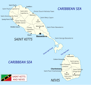
Saint Kitts and Nevis is a twin island country with a total landmass of just 270 square kilometres (104 sq mi). The island of St. Kitts, the larger of the two, is 180 square kilometres (68 sq mi) in size and is located at latitude 17.30 N, and longitude 62.80 W. Nevis is 93 square kilometres (36 sq mi) and located at latitude 17.10 N, longitude 62.35 W, approximately 3 km south-east of St. Kitts. The islands are about one-third of the way from Puerto Rico to Trinidad and Tobago. The islands are volcanic and mountainous.

Basseterre is the capital and largest city of Saint Kitts and Nevis with an estimated population of 14,000 in 2018. Geographically, the Basseterre port is located at 17°18′N62°44′W, on the south-western coast of Saint Kitts Island, and it is one of the chief commercial depots of the Leeward Islands. The city lies within Saint George Basseterre Parish.

Saint Anne Sandy Point is one of 14 administrative parishes that make up Saint Kitts and Nevis. It is the smallest parish on St. Kitts in terms of area, at just 5 square miles (13 km2). It is located on the main island of Saint Kitts and the parish capital is Sandy Point Town.

Saint George Basseterre is one of 14 administrative parishes that make up Saint Kitts and Nevis. It is the largest parish on Saint Kitts and the second largest parish in Saint Kitts and Nevis. It is by far the most populous parish in the federation, holding nearly a third of the country's population. It is home to the city of Basseterre, capital of Saint Kitts and Nevis, and also has a longer coastline than any other parish in Saint Kitts and Nevis.
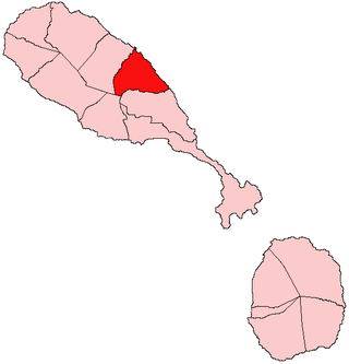
Saint Mary Cayon is one of 14 administrative parishes that make up Saint Kitts and Nevis. It is located on the main island of Saint Kitts and the parish capital is Cayon.
Trinity Palmetto Point is one of 14 administrative parishes that make up Saint Kitts and Nevis. It ranks 6th in terms of size of all the parishes on Saint Kitts. The parish capital is Trinity.

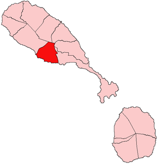
Saint Thomas Middle Island is one of 14 administrative parishes that make up Saint Kitts and Nevis. It is the third largest parish on the island of Saint Kitts, and fourth largest in the federation. The parish capital is Middle Island.

Saint John Figtree is one of five administrative parishes which make up the small Caribbean island of Nevis. These five parishes are part of the fourteen parishes that exist within the Federation of Saint Kitts and Nevis, a two-island country in the Leeward Islands, Lesser Antilles, West Indies.

Saint Thomas Lowland is one of 5 Nevis parishes which are in turn part of the 14 administrative parishes that make up the Federation of Saint Kitts and Nevis. Leeward Islands, Lesser Antilles, West Indies.
Area code 869 is the local telephone area code of Saint Kitts and Nevis. The 869 area code was created during a split from the original (809) area code which began permissive dialing on 1 October 1996 and ended 31 March 1997.
Fort Charles, also called Cleverley Point Fort, is a historic British colonial fort site on the island of St. Kitts, located in the present day nation of Saint Kitts and Nevis in the Caribbean.
The Basseterre Valley is a low-lying valley on the island of Saint Kitts, surrounded by the Canada Hills and Olivees Mountain. It contains Basseterre, the capital of Saint Kitts and Nevis. The valley has two rivers or ghauts named Westbourne Ghaut and College Ghaut.

The Kalinago genocide was the genocidal massacre of an estimated 2,000 Kalinago people by English and French settlers on the island of Saint Kitts in 1626.
Bloody Point is a headland in Trinity Palmetto Point Parish, Saint Kitts. The Stone Fort or Bloody River runs towards Bloody Point. In 1626, English and French colonists massacred 2,000 Kalinago people at Bloody Point.

The Great Salt Pond is the largest lake within Saint Kitts and Nevis.

The Southeast Peninsula of Saint Kitts island is located in Saint Kitts and Nevis, in the Lesser Antilles archipelago of the Caribbean.
Olivees Mountain is the third highest peak on the island of Saint Kitts in the Caribbean.

The Battle of St. Kitts or St. Cristopher was a successful Spanish expedition that seized the islands of Saint Kitts and Nevis from the English and French during the Anglo-Spanish War (1625–30).
References
- ↑ Hubbard, Vincent (2002). A History of St. Kitts . Macmillan Caribbean. pp. 17–18. ISBN 9780333747605.
17°18′11″N62°47′19″W / 17.30306°N 62.78861°W
| | This Saint Kitts and Nevis location article is a stub. You can help Wikipedia by expanding it. |