Related Research Articles
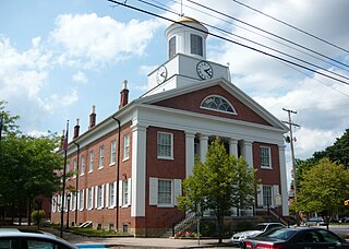
Bedford County is a county located in the U.S. state of Pennsylvania. As of the 2020 census, the population was 47,577. The county seat is Bedford.

Everett is a borough in Bedford County, Pennsylvania, United States. The population was 1,775 at the 2020 census.
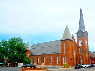
Huntingdon is a borough in Huntingdon County, Pennsylvania, United States. It is located along the Juniata River, approximately 32 miles (51 km) east of Altoona and 92 miles (148 km) west of Harrisburg. With a population of 7,093 at the 2010 census, it is the largest population center near Raystown Lake, a winding, 28-mile-long (45 km) flood-control reservoir managed by the U.S. Army Corps of Engineers.

The Juniata River is a tributary of the Susquehanna River, approximately 104 miles (167 km) long, in central Pennsylvania. The river is considered scenic along much of its route, having a broad and shallow course passing through several mountain ridges and steeply lined water gaps. It formed an early 18th-century frontier region in Pennsylvania and was the site of French-allied Native American attacks against English colonial settlements during the French and Indian War.
Huntingdon and Broad Top Mountain Railroad (H&BTM) is a former short line railroad company operating passenger and freight service on standard gauge track in south central Pennsylvania.

Raystown Lake is a reservoir in Huntingdon County, Pennsylvania. It is the largest lake that is entirely within Pennsylvania. The original lake was built by the Simpson family of Huntingdon as a hydroelectric project. The current 8,300-acre (34 km2) Raystown Lake was completed in 1973 by the Army Corps of Engineers. Raystown is around 200 feet (61 m) deep in the deepest area near the dam. The lake was created primarily to control floods, provide electricity, and support recreational activities. Allegheny Electric Cooperative operates the Raystown Hydroelectric Project and William F. Matson Generating Station at the Raystown Dam, a 21 MW, two-unit hydroelectric project.
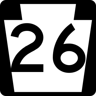
Pennsylvania Route 26 is a 125.5-mile (202.0 km) highway in the south-central area of Pennsylvania. Its northern terminus is at PA 150 northwest of Howard; its southern terminus is at the Maryland state line near Barnes Gap in Union Township. Two major destinations along this route are Raystown Lake near Huntingdon and the Pennsylvania State University at State College.

Warriors Path State Park is a Pennsylvania state park on 349 acres (141 ha) in Liberty Township, Bedford County, Pennsylvania, in the United States. It is named for the Great Indian Warpath that was used by the Iroquois in war raids with the Cherokee and other tribes. Warriors Path State Park is surrounded on three sides by the Raystown Branch Juniata River. The park is a seasonal day use park. The park can be accessed by foot from the main gate when the gate is closed November through mid-April.
Yellow Creek is a 20.9-mile-long (33.6 km) tributary of the Raystown Branch Juniata River in Bedford County, Pennsylvania, in the United States.
Brush Creek is a 24.7-mile-long (39.8 km) tributary of the Raystown Branch Juniata River in Fulton and Bedford counties, Pennsylvania, in the United States.
The Raystown Branch Juniata River is the largest and longest tributary of the Juniata River in south-central Pennsylvania in the United States.

Evitts Mountain is a stratigraphic ridge in the Ridge and Valley region of the Appalachian Mountains, located in Bedford County, Pennsylvania, and Allegany County, Maryland.

Tussey Mountain is a stratigraphic ridge in central Pennsylvania, United States, trending east of the Bald Eagle, Brush, Dunning and Evitts Mountain ridges. Its southern foot just crosses the Mason–Dixon line near Flintstone, Maryland, running north 130 km (80 mi) to the Seven Mountains of central Pennsylvania, near Tusseyville, making it one of the longest named ridges in this section of the Ridge-and-valley Appalachians. The ridge line separates Morrison Cove from the Woodcock Valley and Friends Cove from the Black Valley. Tussey Mountain lies in, and the ridge line forms parts of the borders of, Centre, Blair, Bedford and Huntingdon counties.
Bloody Run may refer to:
Bedford County, Pennsylvania is situated along the western border of the Ridge and Valley physiographic province, which is characterized by folded and faulted sedimentary rocks of early to middle Paleozoic age. The northwestern border of the county is approximately at the Allegheny Front, a geological boundary between the Ridge and Valley Province and the Allegheny Plateau.
Bloody Run is a 1.4-mile-long (2.3 km) tributary of the Raystown Branch Juniata River in Bedford County, Pennsylvania, in the United States.

Pennsylvania Route 915 is a 22-mile-long (35 km) state highway located in Fulton and Bedford Counties in Pennsylvania. The southern terminus is at Interstate 70 (I-70) in Brush Creek Township. The northern terminus is at PA 26 in Hopewell.
Mount Dallas is a populated place in Bedford County, Pennsylvania. It is located in the water gap of Tussey Mountain approximately 1 mile upstream of Everett along the Raystown Branch Juniata River. It was the northern terminus of the now dismantled Bedford and Bridgeport Railroad formerly controlled by the Pennsylvania Railroad, and was one of the main points for the planned South Pennsylvania Railroad that was never completed.
Tenley Park is a community park in the town of Everett, Pennsylvania. It is a 77-acre (310,000 m2) community park located in and owned by the Everett Borough. With many family hiking trails, a playground, geocaching and two pavilions, the park provides a great respite for individual, group and family outings.

The Terrace Mountain Trail is a 25.9-mile (41.7 km) linear hiking trail in south-central Pennsylvania, United States, which is mostly parallel the shore of Raystown Lake. The trail is open to both hiking and mountain biking. The trail is maintained by the US Army Corps of Engineers as part of its management of the Raystown Lake complex. After the development of Raystown Dam and the artificial lake in 1973, the western flank of Terrace Mountain alongside the lake became part of a protected area mostly owned by the federal government, interspersed with some tracts of Pennsylvania's Rothrock State Forest and Trough Creek State Park. The Terrace Mountain Trail visits all these areas.
References
- ↑ "The Raystown Branch Juniata River Water Trail". Archived from the original on 2008-12-01. Retrieved 2009-11-10.
- ↑ "Printer Version - Chesapeake Bay Gateways Network".
- 1 2 3 "Home". raystowncanoeclub.com.
- ↑ Bedford Country Press, Vol. 2, #5, April 24, 1991
- ↑ Bedford Gazette, Bedford, PA, May 17, 2001, Elaine Veach
- 1 2 "Trail Mix : NewPA.com". Archived from the original on 2010-09-28. Retrieved 2009-11-10.
- ↑ https://www.facebook.com/pages/Raystown-Canoe-Club/95661154239?v=info#/pages/Raystown-Canoe-Club/95661154239?v=wall [ user-generated source ]