
Inver Grove Heights is a city in Dakota County, Minnesota, United States. The population was 35,801 at the 2020 census. The city was formed on March 9, 1965, with the merger of the village of Inver Grove and Inver Grove Township.

Nicollet Avenue is a major street in Minneapolis, Richfield, Bloomington, and Burnsville in the U.S. state of Minnesota. It passes through a number of locally well-known neighborhoods and districts, notably Eat Street in south Minneapolis and the traffic-restricted Nicollet Mall in downtown Minneapolis.

The Thames Path is a National Trail following the River Thames from one of its sources near Kemble in Gloucestershire to the Woolwich foot tunnel, south east London. It is about 185 miles (298 km) long. A path was first proposed in 1948 but it only opened in 1996.

Cedar Lake Trail is a 4.3-mile (6.9 km), shared-use path in the U.S. state of Minnesota, from downtown Minneapolis to the neighboring suburb of St. Louis Park. The trail begins at its eastern trailhead in downtown Minneapolis (44°59′11″N93°16′01″W) and continues west to Minnesota State Highway 100 in St. Louis Park (44°57′43″N93°20′36″W). At the trail's west end, a paved path continues for another 4.2 miles (6.8 km) through St. Louis Park to Hopkins under the former name of Hutchinson Spur Trail, but known as North Cedar Lake Regional Trail since 2009. In 2019, large portions of the Cedar Lake Trail were closed due to construction of the Southwest LRT extension with expected reopening in 2021 or 2022.

Minnesota's 3rd congressional district encompasses the suburbs of Hennepin and Anoka counties to the west, south, and north of Minneapolis. The district, which is mostly suburban in character, includes a few farming communities on its far western edge and also inner-ring suburban areas on its eastern edge. The district includes the blue collar cities of Brooklyn Park and Coon Rapids to the north-east, middle-income Bloomington to the south, and higher-income Eden Prairie, Edina, Hopkins, Maple Grove, Plymouth, Minnetonka, and Wayzata to the west. Democrat Kelly Morrison currently represents the district in the U.S. House of Representatives, after being elected in 2024.
Big Rivers Regional Trail is a paved 4.5-mile (7.2 km) rail trail that overlooks the confluence of the Minnesota and Mississippi rivers along the northern edge of Dakota County, Minnesota, United States. It runs between the cities of Eagan and Lilydale.
The Minnesota Valley National Wildlife Refuge is a 14,000-acre (5,666 ha) National Wildlife Refuge in eastern and central Minnesota. Located just south of the city of Minneapolis, it is one of fourteen Regional Priority Urban Wildlife Refuges in the nation. Many parts of the Refuge are near large establishments of the Twin Cities; the Bloomington Education and Visitor Center and two trailheads are located just blocks from the Mall of America, the Wilkie Unit is just east of Valleyfair and the Louisville Swamp Unit is just south of Minnesota Renaissance Festival.

The Mark Trail Wilderness was designated in 1991 and currently consists of 16,400 acres (66 km2). It is named in honor of Mark Trail, a daily newspaper comic strip created by the American cartoonist Ed Dodd. The Wilderness is located within the borders of the Chattahoochee National Forest in White, Towns, and Union counties, Georgia. The Wilderness is managed by the United States Forest Service and is part of the National Wilderness Preservation System.

The Bruce Vento Regional Trail is a rail trail in the cities of Vadnais Heights, Gem Lake, Maplewood, and Saint Paul, Minnesota, USA.

The Gateway District of Minneapolis is centered at the convergence of Hennepin Avenue, Nicollet Avenue, and Washington Avenue. Its borders are not officially designated or recognized, but are visible as the Mississippi River to the northeast, Cedar Lake Trail and the railroad tracks to the northwest, Fifth Avenue South to the southeast. and Fourth Street South to the southwest. The district includes a significant part of the Downtown West neighborhood and abuts the North Loop.
Southwest LRT Trail is a system of shared-use paths for bicycles and pedestrian paths that extends through several western suburbs of Minneapolis, Minnesota. They are operated by the Three Rivers Park District. Two former rail corridors originally built by the Minneapolis and St. Louis Railway were acquired and converted to trails in anticipation of the Southwest Corridor light rail project. The two former railway corridors are now divided into three distinct trails.
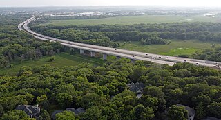
The Bloomington Ferry Bridge is a 1.1-mile-long (1.8 km) freeway bridge across the Minnesota River between Bloomington, Minnesota and Shakopee, Minnesota that carries U.S. Route 169 (US 169). The current bridge and the US 169 Shakopee Bypass were both completed in 1996. The bridge it replaced was designated Hennepin County Road 18 and Scott County Road 18.

U.S. Highway 169 (U.S. 169) is a major north–south highway in the U.S. state of Minnesota, connecting the Minnesota River valley with the Twin Cities and the Iron Range. Much of the route is built to expressway or freeway standards.
The River to River Greenway is a paved multi-use trail in development in Dakota County, Minnesota, United States. Phase II, completed in October 2007, is a 1.3-mile (2.1 km) segment that parallels Minnesota State Highway 110 from Charlton Street to Dodd Road.

The Chaska Bridge is a 4-lane vehicular bridge crossing the Minnesota River on the south side of downtown Chaska, carrying Minnesota State Highway 41. It is 508 feet (155 m) long, and 76.3 feet (23.3 m) wide.

The Minnesota Supercomputing Institute (MSI) in Minneapolis, Minnesota is a core research facility of the University of Minnesota that provides hardware and software resources, as well as technical user support, to faculty and researchers at the university and at other institutions of higher education in Minnesota. MSI is located in Walter Library, on the university's Twin Cities campus.
The Dakota Rail Trail runs 28.1 miles (42.6 km) from Wayzata to Lester Prairie, Minnesota. It is on part of the former track bed of the Hutchinson Spur of the Great Northern Railway. The railway line helped bring wheat and raw materials from Central Minnesota to the flour mills, factories and warehouses in Minneapolis from 1885 until 2001. The railway line, from which there are views of the countryside, was also designed to bring tourists to the communities on Lake Minnetonka in the late 1880s.

Minnehaha Trail is a 1.5-mile (2.4 km) paved, multi-use trail in Minneapolis, Minnesota, United States, that connects Minnehaha Regional Park and Fort Snelling State Park – two of the most popular recreation destinations in the Twin Cities metro area. The trail is considered a segment of a longer, loosely connected bicycle route system along the Mississippi River. Users of Minnehaha Trail traverse under a forest canopy. The trail received local recognition for its natural beauty, but it was criticized for its worn pavement and lack of signage.

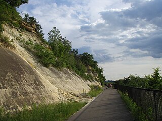
Minnehaha Falls Lower Glen Trail is a popular hiking route in Minneapolis, Minnesota, United States. The 2.1-mile (3.4 km) trail loop begins and ends at the base of the iconic Minnehaha Falls. Hikers follow natural trails and elevated boardwalks through a sedimentary rock glen carved by Minnehaha Creek to its confluence with the Mississippi River where there is a sandy beach. Portions of the trail loop are rated moderate to challenging in difficulty.

Minnesota Valley State Trail is a 27-mile, multi-use trail in the Minneapolis-Saint Paul metropolitan area that runs parallel to the Minnesota River from the cities of Belle Plaine to Shakopee. A 10-mile segment of the trail from Chaska to Shakopee is paved. Allowable trail uses include hiking, biking, horseback riding, cross-country skiing, and snowmobiling. First established in 1969, and never fully completed, the trail is undergoing a 13.5 mile extension in 2019 and 2020.
