
The Eastern Cape is one of the nine provinces of South Africa. Its capital is Bhisho, but its two largest cities are East London and Gqeberha.

The R102 is a Regional Route in South Africa. It is the route designation for all old sections of the N2, thus it is a discontinuous road that resumes in areas where a new N2 has been constructed.

Makhanda, also known as Grahamstown, is a town of about 140,000 people in the Eastern Cape province of South Africa. It is situated about 110 kilometres (70 mi) northeast of Gqeberha and 130 kilometres (80 mi) southwest of East London. It is the largest town in the Makana Local Municipality, and the seat of the municipal council. It also hosts Rhodes University, the Eastern Cape Division of the High Court, the South African Library for the Blind (SALB), a diocese of the Anglican Church of Southern Africa, and 6 South African Infantry Battalion. Furthermore, located approximately 3 km south-east of the town lies the world renowned Waterloo Farm, the only estuarine fossil site in the world from 360 million years ago with exceptional soft-tissue preservation.

The N2 is a national route in South Africa that runs from Cape Town through George, Gqeberha, East London, Mthatha, Port Shepstone and Durban to Ermelo. It is the main highway along the Indian Ocean coast of the country. Its current length of 2,255 kilometres (1,401 mi) makes it the longest numbered route in South Africa.
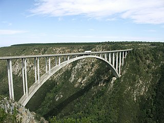
The Bloukrans Bridge is an arch bridge located near Nature's Valley, Western Cape, South Africa. Constructed by Concor between February 1980 and June 1983, the bridge stands at a height of 216m above the Bloukrans River. Its central span is 272m and the bridge is 451m in length in total. Its primary use is that of a road bridge, carrying national route N2.
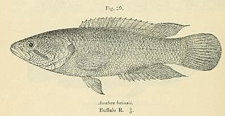
The Eastern Province rocky, also known as rocky kurper, is a species of fish in the family Anabantidae. It is endemic to South Africa.

The Diocese of Grahamstown is a diocese of the Anglican Church of Southern Africa. It is centred on the historic city of Makhanda in the Eastern Cape Province of South Africa. The diocese extends to East London, in the east and Port Alfred to the south.
The Bloukrans Pass is a pass through the ravine of the Bloukrans River on the R102 road between Plettenberg Bay and Jeffreys Bay in South Africa. The Bloukrans River forms the boundary between the Western Cape and Eastern Cape provinces. The pass no longer serves as the main route, as it has been bypassed by the Bloukrans Bridge which carries the N2 national road. The pass underwent major repairs during 2011 on the Western Cape side after flood damage in November 2007.
Blaauwkrantz Pass is a mountain pass on the R67, situated across the Blaauwkrantz Nature Reserve in the Eastern Cape, on the road between Grahamstown and Port Alfred. It traverses the Bloukrans River valley.

The Bushman's River is an east to north-easterly flowing tributary of the Tugela River, in the KwaZulu-Natal province of South Africa. It rises in the Drakensberg Mountain range, with its upper catchment in the Giant's Castle Game Reserve, north of the Giant's Castle promontory. It feeds the Wagendrift Dam and then flows past the town of Estcourt to join the Tugela River near the town of Weenen.

The Kowie River is a river in the Eastern Cape, South Africa. It has its source in the hills of the "Grahamstown Heights" from where it flows in a south-easterly direction draining the major part of the Bathurst region, reaching the Indian Ocean through an estuary at Port Alfred.
The Bloukrans River (KwaZulu-Natal) originates in the Emangosini foothills of the Njesuthi Drakensberg, in the KwaZulu-Natal province of South Africa. It proceeds in a north-easterly direction, passing the village of Frere, until it joins the Tugela River. The river and its tributaries are mostly undammed, though limited irrigation occurs from its upper reaches. Its original Dutch name Blaauwekrans referred to bluish cliff faces present in the area.

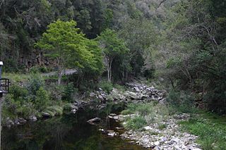
The Bloukrans River is a short river located in the Tsitsikamma region of the Garden Route, South Africa. It is located on the border between the Western Cape and Eastern Cape provinces. The river mouth is located east of Nature's Valley, the Bloukrans Bridge spans the river near the mouth and the Bloukrans Pass is close by. The river originates near Peak Formosa in the Plettenberg Bay region.
Bloukrans River may refer to any of the following rivers in South Africa:
Colchester is a town in the Eastern Cape province of South Africa. It forms part of the Nelson Mandela Bay Metropolitan Municipality which governs Gqeberha and surrounding towns and suburbs.

Bloukrans Bridge Bungy is one of the world's highest commercial bungy jumping sites at 216 metres (709 ft) above the Bloukrans River. It is situated at Bloukrans Bridge on the N2 Highway at the border between the Eastern Cape and the Western Cape in the Tsitsikamma area of South Africa's Garden Route. It has been operated by Face Adrenalin commercially since 1997.
The Diocese of Mbhashe is a diocese of the Anglican Church of Southern Africa situated in the Eastern Cape province of South Africa. It was established on 16 December 2010 out of part of the Diocese of Mthatha. The cathedral is All Saints Church in Ngcobo while the diocesan office is in Butterworth. The diocese includes the areas of Cala, Cofimvaba, Dutywa, Elliot, Kentani and Tsomo. The first and current bishop is Sebenzile Elliot Williams.

Eastern Province Command was a command of the South African Army.
The Blaauwkrantz Nature Reserve is a small protected area near Makhanda (Grahamstown) designated for the purpose of conserving the endangered Eastern Province rocky. Nearby are the Waters Meeting Nature Reserve and Buffalo Kloof Protected Environment. The Blaauwkrantz Pass (R67) runs along the length of the reserve, while the Bloukrans River bisects it horizontally.
The Glen Melville Dam is a dam supplied by the Orange-Fish River Tunnel, near Grahamstown, Eastern Cape, South Africa. It was established in 1992 and its main purpose is for domestic and industrial use.


