
Bungee jumping, also spelled bungy jumping, is an activity that involves a person jumping from a great height while connected to a large elastic cord. The launching pad is usually erected on a tall structure such as a building or crane, a bridge across a deep ravine, or on a natural geographic feature such as a cliff. It is also possible to jump from a type of aircraft that has the ability to hover above the ground, such as a hot-air-balloon or helicopter. The thrill comes from the free-falling and the rebound. When the person jumps, the cord stretches and the jumper flies upwards again as the cord recoils, and continues to oscillate up and down until all the kinetic energy is dissipated.

The Kawarau River is a river in the South Island of New Zealand. It drains Lake Wakatipu in northwestern Otago via the lake's Frankton Arm. The river flows generally eastwards for about 60 kilometres (37 mi) and passes through the steep Kawarau Gorge until it joins Lake Dunstan near Cromwell. Before the construction of the Clyde High Dam, the Kawerau joined the Clutha River in a spectacular confluence at Cromwell. The Shotover River enters the Kawerau from the north; the Nevis River enters it from the south. With many rapids and strong currents, the river can be dangerous and has claimed many lives: it is also popular for bungy jumping and kayaking.

The Weenen massacre was the massacre of Khoikhoi, Basuto and Voortrekkers by the Zulu Kingdom on 17 February 1838. The massacres occurred at Doringkop, Bloukrans River, Moordspruit, Rensburgspruit and other sites around the present day town of Weenen in South Africa's KwaZulu-Natal province.

The Garden Route is a 300-kilometre (190 mi) stretch of the south-eastern coast of South Africa which extends from Witsand in the Western Cape to the border of Tsitsikamma Storms River in the Eastern Cape. The name comes from the verdant and ecologically diverse vegetation encountered here and the numerous estuaries and lakes dotted along the coast. It includes towns such as Knysna, Plettenberg Bay, Mossel Bay, Great Brak River, Little Brak River, Wilderness, Sedgefield and Nature's Valley; with George, the Garden Route's largest city and main administrative centre.

Gamtoos River or Gamptoos River is a river in the Eastern Cape Province, South Africa. It is formed by the confluence of the Kouga River and the Groot River and is approximately 645-kilometre (401 mi) long with a catchment area of 34,635 square kilometres (13,373 sq mi).

The N2 is a national route in South Africa that runs from Cape Town through Gqeberha, East London, Mthatha and Durban to Ermelo. It is the main highway along the Indian Ocean coast of the country. Its current length of 2,255 kilometres (1,401 mi) makes it the longest numbered route in South Africa.
The Tsitsikamma National Park is a protected area on the Garden Route, Western Cape and Eastern Cape, South Africa. It is a coastal reserve well known for its indigenous forests, dramatic coastline, and the Otter Trail. On 6 March 2009 it was amalgamated with the Wilderness National Park and various other areas of land to form the Garden Route National Park.
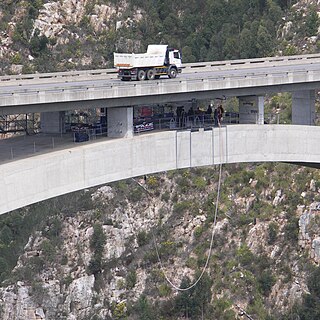
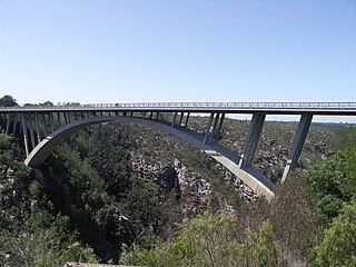
The Bloukrans Bridge is an arch bridge located near Nature's Valley, Western Cape, South Africa. Constructed by Concor between February 1980 and June 1983, the bridge stands at a height of 216m above the Bloukrans River. Its central span is 272m and the bridge is 451m in length in total. Its primary use is that of a road bridge, carrying national route N2.

The Tsitsikamma mountains form an east-west mountain range located in the Garden Route region of the southern South African coast in the Western Cape and Eastern Cape provinces. Tsitsikamma means 'place of much water' in the Khoekhoe language.
The Garden Route National Park is a national park in the Garden Route region of the Western Cape and Eastern Cape provinces in South Africa. It is a coastal reserve well known for its indigenous forests, dramatic coastline, and the Otter Trail. It was established on 6 March 2009 by amalgamating the existing Tsitsikamma and Wilderness National Parks, the Knysna National Lake Area, and various other areas of state-owned land.
The Paul Sauer Bridge, also known as the Storms River Bridge, is a deck arch bridge over the Storms River in the Eastern Cape of South Africa. The bridge is located on the Garden Route section of National Route 2, between Cape Town and Port Elizabeth. At a maximum height of 120 metres (394 ft) above the Storms River, it was the highest concrete arch in Africa until the Bloukrans Bridge, 216 metres (709 ft), opened on the same road in 1984.

The Kawarau Gorge Suspension Bridge is a bridge which runs over the Kawarau River in the Otago region in the South Island of New Zealand. The bridge is mainly used for commercial purposes by the AJ Hackett Bungy Company for the purposes of bungy jumping; the site was the world's first commercial bungy jumping site. The bridge also forms part of the Queenstown Trail which allows walkers/runners and bikers to pass over the river. The bridge is inside a Department of Conservation reserve.
The Bloukrans Pass is a pass through the ravine of the Bloukrans River on the R102 road between Plettenberg Bay and Jeffreys Bay in South Africa. The Bloukrans River forms the boundary between the Western Cape and Eastern Cape provinces. The pass no longer serves as the main route, as it has been bypassed by the Bloukrans Bridge which carries the N2 national road. The pass underwent major repairs during 2011.

Grootrivier Pass, is situated in the Western Cape province of South Africa on the R102 regional road. The Grootrivier is one of various mountain streams that over millions of years have cut through the coastal plateau towards the sea.

The Kowie River is a river in the Eastern Cape, South Africa. It has its source in the hills of the "Grahamstown Heights" from where it flows in a south-easterly direction draining the major part of the Bathurst region, reaching the Indian Ocean through an estuary at Port Alfred.
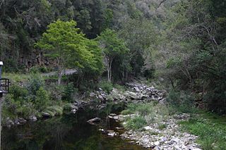
The Bloukrans River (KwaZulu-Natal) originates in the Emangosini foothills of the Njesuthi Drakensberg, in the KwaZulu-Natal province of South Africa. It proceeds in a north-easterly direction, passing the village of Frere, until it joins the Tugela River. The river and its tributaries are mostly undammed, though limited irrigation occurs from its upper reaches. Its original Dutch name Blaauwekrans referred to bluish cliff faces present in the area.
Bloukrans River may refer to any of the following rivers in South Africa:

Bloukrans Bridge Bungy is one of the world's highest commercial bridge bungy at 216 metres (709 ft) above the Bloukrans River. It is situated at Bloukrans Bridge on the N2 Highway at the border between the Eastern Cape and the Western Cape in the Tsitsikamma area of South Africa's Garden Route. It has been operated by Face Adrenalin commercially since 1997.
Middleton is a hamlet in the Blue Crane Route Local Municipality of the Sarah Baartman District Municipality in the Eastern Cape province of South Africa. Middleton is situated on the banks of the Fish River off the N10 road and is about 30 km south of Cookhouse.
The Tstsikamma Marine Protected Area is a marine protected area on the south coast of South Africa, in both the Western Cape and Eastern Cape. It is on the coast of the Tsitsikamma National Park, and is one of the oldest MPAs in the country. The MPA provides protection for marine habitat and wildlife, including birds and threatened and endangered fish species.
