
The Weenen massacre was the massacre of Khoikhoi, Basuto and Voortrekkers by the Zulu Kingdom on 17 February 1838. The massacres occurred at Doringkop, Bloukrans River, Moordspruit, Rensburgspruit and other sites around the present day town of Weenen in South Africa's KwaZulu-Natal province.
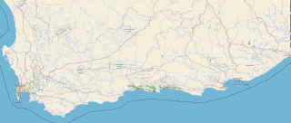
The Garden Route is a 300-kilometre (190 mi) stretch of the south-eastern coast of South Africa which extends from Witsand in the Western Cape to the border of Tsitsikamma Storms River in the Eastern Cape. The name comes from the verdant and ecologically diverse vegetation encountered here and the numerous estuaries and lakes dotted along the coast. It includes towns such as Knysna, Plettenberg Bay, Mossel Bay, Oudtshoorn, Great Brak River, Little Brak River, Wilderness, Sedgefield and Nature's Valley; with George, the Garden Route's largest city and main administrative centre.

The R102 is a Regional Route in South Africa. It is the route designation for all old sections of the N2, thus it is a discontinuous road that resumes in areas where a new N2 has been constructed.
The R355 is a Regional Route in South Africa that connects the R46 near Ceres with Springbok via Calvinia.

The N2 is a national route in South Africa that runs from Cape Town through George, Gqeberha, East London, Mthatha and Durban to Ermelo. It is the main highway along the Indian Ocean coast of the country. Its current length of 2,255 kilometres (1,401 mi) makes it the longest numbered route in South Africa.
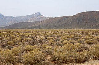
The Roggeveld Mountains is a mountain range situated mainly in the Northern Cape province of South Africa. The range forms the western escarpment of the eponymous Roggeveld plateau, and separates it from the lower lying Tankwa Karoo to the west. Its highest peak is Sneeukrans, situated northwest of Sutherland.

The Tsitsikamma National Park is a protected area on the Garden Route, Western Cape and Eastern Cape, South Africa. It is a coastal reserve well known for its indigenous forests, dramatic coastline, and the Otter Trail. On 6 March 2009 it was amalgamated with the Wilderness National Park and various other areas of land to form the Garden Route National Park.

The Liesbeek River is a river in Cape Town in South Africa. It is named after a small river in the Netherlands. The first "free burghers" of the Dutch East India Company were granted land to farm along the river in 1657, shortly after the first Dutch settlers arrived in the Cape. The river was originally called the Amstel or Versse Rivier. It is the first river that Jan van Riebeeck named.
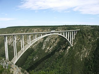
The Bloukrans Bridge is an arch bridge located near Nature's Valley, Western Cape, South Africa. Constructed by Concor between February 1980 and June 1983, the bridge stands at a height of 216m above the Bloukrans River. Its central span is 272m and the bridge is 451m in length in total. Its primary use is that of a road bridge, carrying national route N2.

The Tsitsikamma mountains form an east-west mountain range located in the Garden Route region of the southern South African coast in the Western Cape and Eastern Cape provinces. Tsitsikamma means 'place of much water' in the Khoekhoe language.

The Redoubt Duijnhoop was a square demi-bastioned clay and timber Redoubt built fort constructed at the mouth of the Salt River, leading into Table Bay, South Africa in January–February 1654. It formed part of the defences of the Vereenigde Oost-Indische Compagnie 'VOC' replenishment station, which had been established under Jan van Riebeeck in 1652. The purpose of the station was to supply ships travelling between the Netherlands and the Dutch East Indies.
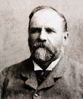
Thomas Charles John Bain was a South African road engineer. As a prolific road building pioneer, Bain was responsible for the planning and construction of more than 900 km of roads and mountain passes, many of them still in use today, over a career spanning from 1848 until 1888. These passes through the mountain ranges between the thin coastal plain and the interior of the former Cape Colony in South Africa, played a major role in opening up the vast hinterland of South Africa.

Grootrivier Pass, is situated in the Western Cape province of South Africa on the R102 regional road. The Grootrivier is one of various mountain streams that over millions of years have cut through the coastal plateau towards the sea.
Blaauwkrantz Pass is a mountain pass on the R67, situated in the Blaauwkrantz Nature Reserve in the Eastern Cape, on the road between Grahamstown and Port Alfred. It traverses the Bloukrans River valley.
The Bloukrans Pass of the Onder-Bokkeveld region, is located on the R355 road between Ceres and Calvinia, in the Northern Cape province of South Africa. It navigates the lower slopes of the Bloukrans Mountain on its eastern shoulder, and has the Nuwewater se berg on its western side. The Bloukrans Mountain is the northern promontory of the Roggeveld Mountains.
The Bloukrans River (KwaZulu-Natal) originates in the Emangosini foothills of the Njesuthi Drakensberg, in the KwaZulu-Natal province of South Africa. It proceeds in a north-easterly direction, passing the village of Frere, until it joins the Tugela River. The river and its tributaries are mostly undammed, though limited irrigation occurs from its upper reaches. Its original Dutch name Blaauwekrans referred to bluish cliff faces present in the area.

The Bloukrans River is a short river located in the Tsitsikamma region of the Garden Route, South Africa. It is located on the border between the Western Cape and Eastern Cape provinces. The river mouth is located east of Nature's Valley, the Bloukrans Bridge spans the river near the mouth and the Bloukrans Pass is close by. The river originates near Peak Formosa in the Plettenberg Bay region.
Bloukrans River may refer to any of the following rivers in South Africa:
Bloukrans Pass may refer to one of the following:

Bloukrans Bridge Bungy is one of the world's highest commercial bungy jumping sites at 216 metres (709 ft) above the Bloukrans River. It is situated at Bloukrans Bridge on the N2 Highway at the border between the Eastern Cape and the Western Cape in the Tsitsikamma area of South Africa's Garden Route. It has been operated by Face Adrenalin commercially since 1997.
