
The Drakensberg is the eastern portion of the Great Escarpment, which encloses the central Southern African plateau. The Great Escarpment reaches its greatest elevation – 2,000 to 3,482 metres within the border region of South Africa and Lesotho.

Helderberg refers to a planning district of the City of Cape Town metropolitan municipality, the mountain after which it is named, a wine-producing area in the Western Cape province of South Africa, or a small census area in Somerset West.
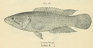
The Eastern Province rocky, also known as rocky kurper, is a species of fish in the family Anabantidae. It is endemic to South Africa.
The Bloukrans River (Grahamstown) is a tributary of the Kowie River, and is situated near Grahamstown in the Eastern Cape province of South Africa. The endangered Eastern Province rocky is found in the Bloukrans River section of the Blaauwkrantz Nature Reserve.

The Kowie River is a river in the Eastern Cape, South Africa. It has its source in the hills of the "Grahamstown Heights" from where it flows in a south-easterly direction draining the major part of the Bathurst region, reaching the Indian Ocean through an estuary at Port Alfred.
The Kangaroo River Nature Reserve, part of the Kangaroo Valley Group of Nature Reserves, is a protected nature reserve that is located on the floor of the Kangaroo Valley in the Southern Highlands and South Coast regions of New South Wales in eastern Australia. The reserve is situated approximately 150 kilometres (93 mi) south of Sydney, 50 kilometres (31 mi) southwest of Wollongong and 16 kilometres (9.9 mi) northwest of Nowra. The reserve has a protective covenant placed upon it with purpose to ensure the protection of the natural heritage of this area. National parks in the area include the Morton National Park and the Budderoo National Park. Other nature reserves in the area include the Barren Grounds Nature Reserve, and the Cambewarra Range, Barrengarry and Rodway nature reserves – the latter three part of the Kangaroo Valley Group of Nature Reserves.
The Betty's Bay Marine Protected Area is part of the Kogelberg Biosphere Reserve. It is about 29km south-east of Gordon's Bay and approximately 37km north-west of Hermanus on the south-western coast of the Western Cape. It is in the Atlantic Ocean immediately adjacent to the town of Betty's Bay, in the Overstrand Municipal area.

The De Hoop Marine Protected Area lies between Arniston and the mouth of the Breede River on the south coast of South Africa adjacent to the De Hoop Nature Reserve. The MPA is 51 kilometres long, and extends 5 nautical miles to sea. The whole MPA is a restricted area and is part of the migratory route and calving area for Southern right whales. The area protects habitats for several economically important inshore reef fish species, and ensures the retention of marine biomass in this part of the coast. The limestone coastline is includes archaeological sites and middens that date back centuries. The MPA is close to the Breede River estuary and, provides protection for species like cob that breed in the estuary and then return to the ocean.
The Helderberg Marine Protected Area is a small marine conservation area on the north-eastern side of False Bay in the Western Cape province of South Africa, It lies between the mouths of the Lourens River in the Strand, and the Eerste River in Macassar.
The Goukamma Marine Protected Area is an inshore conservation region near Knysna in the Western Cape province in the territorial waters of South Africa
The Dwesa-Cwebe Marine Protected Area is an inshore and offshore conservation region, off the coast of the Dwesa-Cwebe Nature Reserve in the Eastern Cape province, in the territorial waters of South Africa.
The Hluleka Marine Protected Area is an inshore conservation region in the territorial waters of the Eastern Cape province of South Africa.
The Stilbaai Marine Protected Area is an inshore conservation region in the territorial waters near Stilbaai on the south coast of the Western Cape province of South Africa.
The Sardinia Bay Marine Protected Area is an inshore conservation region in the territorial waters of the Eastern Cape province, South Africa
The Rocherpan Marine Protected Area is a small coastal conservation region on the West Coast of the Western Cape province, in the territorial waters of South Africa. It is about 25 km north of Velddrif on the road to Elands Bay, north of Dwarskersbos.
The Amathole Marine Protected Area is an inshore conservation region in the territorial waters of South Africa, near East London on the coast of the Eastern Cape.
The Trafalgar Marine Protected Area is an inshore conservation region in the territorial waters of South Africa in kwaZulu-Natal, between Port Edward and Margate.


