
Mpumalanga is a province of South Africa. The name means "East", or literally "The Place Where the Sun Rises" in the Swazi, Xhosa, Ndebele and Zulu languages. Mpumalanga lies in eastern South Africa, bordering Eswatini and Mozambique. It constitutes 6.5% of South Africa's land area. It shares borders with the South African provinces of Limpopo to the north, Gauteng to the west, the Free State to the southwest, and KwaZulu-Natal to the south. The capital is Mbombela. Mpumalanga was formed in 1994, when the area that was the Eastern Transvaal was merged with the former bantustans KaNgwane, KwaNdebele and parts of Lebowa and Gazankulu. Although the contemporary borders of the province were only formed at the end of apartheid, the region and its surroundings has a history that extends back thousands of years. Much of its history, and current significance is as a region of trade.
The N21 is a proposed national route in the City of Cape Town, South Africa. It is also known as Peninsula Expressway ring road. Once complete, it will link the northern suburbs on the Atlantic seaboard with the southern suburbs on False Bay (Muizenberg). The R300 Freeway is entirely part of the proposed route.

The N2 is a national route in South Africa that runs from Cape Town through George, Gqeberha, East London, Mthatha, Port Shepstone and Durban to Ermelo. It is the main highway along the Indian Ocean coast of the country. Its current length of 2,255 kilometres (1,401 mi) makes it the longest numbered route in South Africa.

Concor Holdings (Proprietary) Limited. is a South African construction and mining services company. It is active throughout Southern Africa, involved in mining, civil engineering, building and road projects. Concor returned as an independent brand in late 2016.

Kalk Bay is a fishing village on the coast of False Bay, South Africa and is now a suburb of greater Cape Town. It lies between the ocean and sharply rising mountainous heights that are buttressed by crags of grey Table Mountain Sandstone. The railway from Cape Town to Simon's Town passes through Kalk Bay and in some places the line is only metres from the water's edge.

The Hottentots Holland Mountains are part of the Cape Fold Belt in the Western Cape, South Africa. The mountain range forms a barrier between the Cape Town metropolitan area and the southern Overberg coast.
Mpofu Nature Reserve is a nature reserve in the Amatole district of the Eastern Cape Province, South Africa that is managed by Eastern Cape Parks.
Orrie Baragwanath Pass is situated in the Limpopo Province on the unnumbered road between Ofcolaco and Lebowakgomo. The pass has a steep paved ascent from the east up the slopes of the far northern Drakensberg mountains to a height of 1370 m above sea level. From the west there is an equally steep but unpaved ascent with a fairly flat unpaved section of approximately 10 kilometers along the summit between the two approaches. Although most of the pass is located in the Lekgalameetse Provincial Park, it is nevertheless a public road with free access. Access fee is payable if entering the pass from the Lekgalameetse entrance gate.
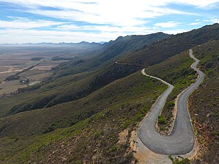
Dasklip Pass is situated in the Western Cape province of South Africa on an off-road near Porterville along the R365 highway. The road provides access to the plateau in the Groot Winterhoek mountains and the Groot Winterhoek Wilderness Area; summiting at a height of 700 metres above sea level. It was privately built by farmers located on the plateau. The road was upgraded to an asphalt road in the early 2000s.

Van Stadens Pass is situated in the Eastern Cape, province of South Africa, on the R102 regional route, between Port Elizabeth and Humansdorp. It is a passage through the gorge of the Van Stadens River.

Wapadsberg Pass, is a mountain pass situated in the Eastern Cape province of South Africa, on the regional road R61, between Graaff-Reinet and Cradock, Eastern Cape.

The Kowie Railway 4-4-0T of 1882 was a South African steam locomotive from the pre-Union era in the Cape of Good Hope.
The Blaauwkrantz Bridge disaster occurred on 22 April 1911. A mixed train from Port Alfred travelling to Grahamstown, made up of six goods trucks, three passenger carriages and a guard's van, came to grief when one of the goods trucks derailed on the Blaauwkrantz Bridge over the Blaauwkrantz Pass and, with the three carriages and the guard's van, plunged into the ravine 200 feet below. Of the 55 passengers, 28 were killed and 22 seriously injured.
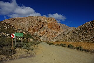
Seweweekspoort is a mountain pass located along the R323 regional route running from Zoar and Laingsburg in the western Little Karoo region of South Africa's Western Cape province. The highest point in the Western Cape, Seweweekspoort Peak, is located close to the pass. The pass and surrounding area is a popular tourist attraction due to the diversity of local flora and the geology of the surrounding mountains.
The Potters Pass Nature Reserve is a coastal reserve in the Wild Coast region of the Eastern Cape. The reserve lies beside the Hood Point Lighthouse and the West Bank Golf Course.
The Blaauwkrantz Nature Reserve is a small reserve near Makhanda (Grahamstown) designated for the purpose of conserving the endangered Eastern Province rocky. Nearby is the Waters Meeting Nature Reserve and Buffalo Kloof Protected Environment. The Blaauwkrantz Pass (R67) runs along the length of the reserve, while the Bloukrans River bisects it horizontally.
Marthinus Prinsloo was an Orange Free State Boer farmer, politician and general in the Second Boer War (1899-1902). He was born of Nicolaas Frans Prinsloo (1813-1890) and Isabella Johanna Petronella Rautenbach in the district of Graaff-Reinet, South Africa who migrated to the Orange Free State where they lived in Bloemfontein, Waterval and Bethlehem.
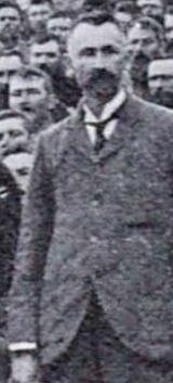
Paul Hendrik Roux was a Second Boer War general and a Protestant pastor in the Dutch Reformed Church in South Africa (NGK).

Jonathan Crowther was a Boer war general.

The Brandwater Basin is the drainage basin of the Brandwater River, a tributary of the Grootspruit River in the south-east of Orange Free State, South Africa, north of Lesotho. The basin is situated south of Bethlehem and south-east of Senekal, between the Witteberg to the west and north, the Rooiberge to the east, and the Drakensberg over the Caledon River to the south. It is also northwest of the Slaapkrans Basin and the Maloti Mountains on the northern border of Lesotho. Towns in the Brandwater Basin are Fouriesburg, founded in 1892, and Clarens, established in 1912.


