Blowout (geomorphology)

Last updated
Blowout located 6.5 km south of Earth, Texas (1996) Blowout Earth TX.jpg
Blowout located 6.5 km south of Earth, Texas (1996)

Blowouts are sandy depressions in a sand dune ecosystem (psammosere) caused by the removal of sediments by wind.

Contents

Commonly found in coastal settings and margins of arid areas, blowouts tend to form when wind erodes patches of bare sand on stabilized vegetated dunes. Generally, blowouts do not form on actively flowing dunes due to the fact that the dunes need to be bound to some extent, for instance by plant roots. These depressions usually start on the higher parts of stabilized dunes on account of the more considerable desiccation and disturbances occurring there, which allows for greater surface drag and sediment entrainment when the sand is bare. Most of the time, exposed areas become quickly re-vegetated before they can become blowouts and expand; however, when circumstances are favourable, wind erosion can gouge the exposed surface and create a tunneling effect which increases local wind speed. A depression may then develop until it hits a non-erodible substrate, or morphology limits it. The eroded substances climb the steep slopes of the depression and become deposited on the downwind side of the blowout which can form a dune that covers vegetation and lead to a larger depression; a process that helps create parabolic dunes. [1]

Note that volcanic features that take the form of depressions are sometimes informally called blowouts, such as "The Blowout" (a lava lake) or "Big Blowout Butte" in central Idaho. [2]

Vegetation

Although there is a wide variety of vegetation that live in dune environments around the world, most plant species play a key role in determining whether blowouts will form or not by the result of how strong their protective skins can suppress erosion and how capable some pioneer species can repress further erosion if a dune becomes exposed. [3]

Protective skin

In the first case, the primary objective for the protective skin is to resist disturbances that will form open exposures and create blowouts. To prevent erosion, vegetation helps reduce shear stress by covering the surface and mechanically binding soil together. The protective skin is composed of vegetation that is above and below ground surface and decomposing plant litter. Additionally, the protective skin can also be composed of a wide variety of species that could constitute environments like grasslands and forest. However, if the climate changes, it can directly influence the health of the vegetation, which can make the skin fragile; nevertheless, the rate of change may take some time and may be different for stabilized dunes in different environments. [3]

Pioneer species

Once disturbances destroy a portion of the protective skin, the exposure can expand and erode other portions of the skin; however, some vegetation, such as pioneer species, can settle in an opening and prevent any further expansion and deflation. Even though a few plants species can be classed as colonizers, these plants tend to withstand high rates of sediment deposition and poor nutrient conditions in the blowout. Moreover, if a blowout does form, the deposited material that travels out of the depression can either continue to become deposited at a greater rate than pioneer vegetation can grow, or become stabilized again. Mostly due to changes in the climate, colonizer species heavily rely on conditions of the environment, which can change dramatically unlike the vegetation in the protective skin. [3]

Coastal sand dunes are found just inland from a beach, and are formed as the wind blows dry sand inland beyond the beach. It follows that this can only happen when there is an area of reasonably flat land inland from the beach. In time, this rather inhospitable surface will be colonised by pioneer species. These species (e.g. marram grass) will stabilise the dunes and prevent them moving any more. The process of plant succession will eventually see these dunes converted to woodland (depending on the climate) and a mature soil will have formed. [4]

Blowouts provide an important habitat for flora and fauna. [5]

Disturbances

Disturbances are general phrases which define a cause that creates an exposure in the vegetative skin to eventually form a blowout formation. Rather than being described as events, disturbances are terms which describe the rate at which breaches create an opening and expand, yet there are numerous types of disturbances that can penetrate the protective vegetative skin. Despite the fact that many factors could influence blowout formations, disturbances usually have three characteristics which determine if a depression will form and expand. The first property states that disturbances must have a penetration magnitude greater than the toughness of the protective vegetative skin. Simply put, if the breach cannot remove the shielding vegetation, then wind erosion cannot create a depression in stabilized dunes. The second property asserts that sediment transportation in an exposure would be limited if exposure's spatial coverage is too small. Presuming that the opening is very compacted, the fetch length would also be very cramped which does not allow much sediment particles to be moved out of the exposure. Lastly, the third property exclaims that spatial configuration of the disturbed openings greatly influences the fetch length and sediment transportation in the exposure. If there were numerous disturbed patches that borderline each other in a downwind direction, wind erosion may be capable of removing and transporting large amounts of sediment particles, which could create blowouts. Thus, although the scale of the disturbances does assist in blowout formation, these characteristics generally help dictate if Aeolian processes can create a depression or not. [3]

Airflow dynamics and morphology

Once an exposure has been spawned, the morphology of the blowout depends on the interaction of wind speed and direction with the stabilized dune's vegetation and topography. There is a wide range of blowout types that form depending on these factors; however, the scientific community mostly utilizes two types of blowouts: trough and saucer. Although there is no obvious reason why one type is formed rather than another in a particular region, saucer blowouts generally have semicircular and saucer shapes while trough blowouts have more elongated shapes with deep deflation basins and steeper slopes. Nevertheless, both types of blowouts have structures that can affect wind flow within the basin. [6]

In troughs, the structure's topography can accelerate flows and form jets that result in maximum erosion along the deflation basin floor and laterally expand the slopes of the blowout. Additionally, when the wind flows on top of the blowout's lateral walls, sediment transport is at its maximum in the middle axis of the trough depositional lobe, leading to formation of a parabolic dune. [6] Although some studies like Hesp and Pringle (2001) noted that wind flow that was oblique to the blowouts’ orientation became pulled into the depression due to a zone of low pressure at the deflation basin and was steered parallel to the orientation of the trough blowout. However, in Smyth, Jackson, and Cooper’s study (2014), little evidence supported that wind flow was being steered along the axis of the blowout, but rather the flow remained constant in the direction that it was flowing before or showed other characteristics like turbulent separated flows. [7]

Saucer blowouts indicate a deceleration of wind flow along the deflation basin as the structure widens over time by reversing flows eroding the sides and expanding upwind. Due to rapid deceleration, saucers tend to form short, wide, radial depositional slopes. [6] When wind flow enters a saucer shape blowout, the wind speed decreases upon entering the blowout and accelerates at the downwind side of the formation. A zone of separation develops along the lee slope as the wind enters the blowout and decrease in speed, yet it accelerates again as it re-attaches at the basin and flow up to the depositional lobe, where sand becomes evacuated. [8]

Even though they are more influences blowout structures have on their morphology, both types basically tend to have deflation basins eroded until they reach their non-erodible base level. A study conducted by Hesp (1982) indicates that depositional length is not correlated with the eroded depth but rather the blowout width. In other words, as the depositional lobe increases, the blowout width also increases by a ratio of 1:2 to 1:3 in saucer blowouts and 1:4 in trough blowouts. [6]

See also

Related Research Articles

<span class="mw-page-title-main">Dune</span> Hill of loose sand built by aeolian processes or the flow of water

A dune is a landform composed of wind- or water-driven sand. It typically takes the form of a mound, ridge, or hill. An area with dunes is called a dune system or a dune complex. A large dune complex is called a dune field, while broad, flat regions covered with wind-swept sand or dunes, with little or no vegetation, are called ergs or sand seas. Dunes occur in different shapes and sizes, but most kinds of dunes are longer on the stoss (upflow) side, where the sand is pushed up the dune, and have a shorter slip face in the lee side. The valley or trough between dunes is called a dune slack.

<span class="mw-page-title-main">Erosion</span> Natural processes that remove soil and rock

Erosion is the action of surface processes that removes soil, rock, or dissolved material from one location on the Earth's crust and then transports it to another location where it is deposited. Erosion is distinct from weathering which involves no movement. Removal of rock or soil as clastic sediment is referred to as physical or mechanical erosion; this contrasts with chemical erosion, where soil or rock material is removed from an area by dissolution. Eroded sediment or solutes may be transported just a few millimetres, or for thousands of kilometres.

<span class="mw-page-title-main">Beach</span> Area of loose particles at the edge of the sea or other body of water

A beach is a landform alongside a body of water which consists of loose particles. The particles composing a beach are typically made from rock, such as sand, gravel, shingle, pebbles, etc., or biological sources, such as mollusc shells or coralline algae. Sediments settle in different densities and structures, depending on the local wave action and weather, creating different textures, colors and gradients or layers of material.

<span class="mw-page-title-main">Sediment</span> Particulate solid matter that is deposited on the surface of land

Sediment is a naturally occurring material that is broken down by processes of weathering and erosion, and is subsequently transported by the action of wind, water, or ice or by the force of gravity acting on the particles. For example, sand and silt can be carried in suspension in river water and on reaching the sea bed deposited by sedimentation; if buried, they may eventually become sandstone and siltstone through lithification.

<span class="mw-page-title-main">Ventifact</span> Rock that has been eroded by wind-driven sand or ice crystals

A ventifact is a rock that has been abraded, pitted, etched, grooved, or polished by wind-driven sand or ice crystals. These geomorphic features are most typically found in arid environments where there is little vegetation to interfere with aeolian particle transport, where there are frequently strong winds, and where there is a steady but not overwhelming supply of sand.

Landforms are categorized by characteristic physical attributes such as their creating process, shape, elevation, slope, orientation, rock exposure, and soil type.

<span class="mw-page-title-main">Aeolian processes</span> Processes due to wind activity

Aeolian processes, also spelled eolian, pertain to wind activity in the study of geology and weather and specifically to the wind's ability to shape the surface of the Earth. Winds may erode, transport, and deposit materials and are effective agents in regions with sparse vegetation, a lack of soil moisture and a large supply of unconsolidated sediments. Although water is a much more powerful eroding force than wind, aeolian processes are important in arid environments such as deserts.

<span class="mw-page-title-main">Yardang</span> Streamlined aeolian landform

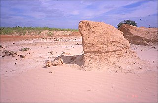
A yardang is a streamlined protuberance carved from bedrock or any consolidated or semiconsolidated material by the dual action of wind abrasion by dust and sand and deflation. Yardangs become elongated features typically three or more times longer than wide, and when viewed from above, resemble the hull of a boat. Facing the wind is a steep, blunt face that gradually gets lower and narrower toward the lee end. Yardangs are formed by wind erosion, typically of an originally flat surface formed from areas of harder and softer material. The soft material is eroded and removed by the wind, and the harder material remains. The resulting pattern of yardangs is therefore a combination of the original rock distribution, and the fluid mechanics of the air flow and resulting pattern of erosion.

<span class="mw-page-title-main">Depression (geology)</span> Landform sunken or depressed below the surrounding area

In geology, a depression is a landform sunken or depressed below the surrounding area. Depressions form by various mechanisms.

<span class="mw-page-title-main">Desert pavement</span> Type of desert earth surface

A desert pavement, also called reg, serir, gibber, or saï is a desert surface covered with closely packed, interlocking angular or rounded rock fragments of pebble and cobble size. They typically top alluvial fans. Desert varnish collects on the exposed surface rocks over time.

<span class="mw-page-title-main">Dreikanter</span> Type of rock

A Dreikanter is a type of ventifact that typically forms in desert or periglacial environments due to the abrasive action of blowing sand.

<span class="mw-page-title-main">Erg (landform)</span> Broad area of desert covered with wind-swept sand

An erg is a broad, flat area of desert covered with wind-swept sand with little or no vegetative cover. The word is derived from the Arabic word ʿarq (عرق), meaning "dune field". Strictly speaking, an erg is defined as a desert area that contains more than 125 km2 (48 sq mi) of aeolian or wind-blown sand and where sand covers more than 20% of the surface. Smaller areas are known as "dune fields". The largest hot desert in the world, the Sahara, covers 9 million square kilometres and contains several ergs, such as the Chech Erg and the Issaouane Erg in Algeria. Approximately 85% of all the Earth's mobile sand is found in ergs that are greater than 32,000 km2 (12,355 sq mi), the largest being the Rub' al Khali, the Empty Quarter of the Arabian Peninsula. Ergs are also found on other celestial bodies, such as Venus, Mars, and Saturn's moon Titan.

<span class="mw-page-title-main">Cross-bedding</span> Sedimentary rock strata at differing angles

In geology, cross-bedding, also known as cross-stratification, is layering within a stratum and at an angle to the main bedding plane. The sedimentary structures which result are roughly horizontal units composed of inclined layers. The original depositional layering is tilted, such tilting not being the result of post-depositional deformation. Cross-beds or "sets" are the groups of inclined layers, which are known as cross-strata.

<span class="mw-page-title-main">Ripple marks</span> Wave structures created in sediments by bottom current

In geology, ripple marks are sedimentary structures and indicate agitation by water or wind.

<span class="mw-page-title-main">Sand dune stabilization</span> Coastal management practice

Sand dune stabilization is a coastal management practice designed to prevent erosion of sand dunes. Sand dunes are common features of shoreline and desert environments. Dunes provide habitat for highly specialized plants and animals, including rare and endangered species. They can protect beaches from erosion and recruit sand to eroded beaches. Dunes are threatened by human activity, both intentional and unintentional. Countries such as the United States, Australia, Canada, New Zealand, the United Kingdom, and Netherlands, operate significant dune protection programs.

<span class="mw-page-title-main">Sedimentary structures</span> Geologic structures formed during sediment deposition

Sedimentary structures include all kinds of features in sediments and sedimentary rocks, formed at the time of deposition.

Aeolian landforms are features produced by either the erosive or depositive action of the wind. These features may be built up from sand or snow, or eroded into rock, snow, or ice. Aeolian landforms are commonly observed in sandy deserts and on frozen lakes or sea ice and have been observed and studied across Earth and on other planets, including Mars and Pluto

A foredune is a dune ridge that runs parallel to the shore of an ocean, lake, bay, or estuary. Foredunes consist of sand deposited by wind on a vegetated part of the shore. Foredunes can be classified generally as incipient or established.

<span class="mw-page-title-main">Inland dune</span>

Inland dunes are eolian sand dunes that are found inland, away from coastal regions.

<span class="mw-page-title-main">Tropical desert</span> Type of desert

Tropical deserts are located in regions between 15 and 30 degrees latitude. The environment is very extreme, and they have the highest average monthly temperature on Earth. Rainfall is sporadic; precipitation may not be observed at all in a few years. In addition to these extreme environmental and climate conditions, most tropical deserts are covered with sand and rocks, and thus too flat and lacking in vegetation to block out the wind. Wind may erode and transport sand, rocks and other materials; these are known as eolian processes. Landforms caused by wind erosion vary greatly in characteristics and size. Representative landforms include depressions and pans, Yardangs, inverted topography and ventifacts. No significant populations can survive in tropical deserts due to extreme aridity, heat and the paucity of vegetation; only specific flora and fauna with special behavioral and physical mechanisms are supported. Although tropical deserts are considered to be harsh and barren, they are in fact important sources of natural resources and play a significant role in economic development. Besides the equatorial deserts, there are many hot deserts situated in the tropical zone.

References

  1. Livingstone, Ian, and Andrew Warren. Aeolian Geomorphology: An Introduction. Wesley Longman Limited, 1996. Print.
  2. Kuntz, M.A., Skipp, Betty, Champion, D.E., Gans, P.B., Van Sistine, D.P., and Snyders, S.R., 2007. Geologic map of the Craters of the Moon 30' X 60' quadrangle, Idaho . U.S. Geological Survey, Scientific Investigations Map SIM-2969. Map Scale: 1:100,000.
  3. 1 2 3 4 Barchyn, Thomas E, and Chris H Hugenholtz. "Reactivation of Supply-limited Dune Fields from Blowouts: A Conceptual Framework for State Characterization." Geomorphology, 201 (2013): 172-182.
  4. Hugenholtz, C.H. and Wolfe, S.A. 2006. Morphodynamics and climate controls of two aeolian blowouts on the northern Great Plains, Canada. Earth Surface Processes and Landforms 31(12):1540-1557.
  5. Rydberg, P.A. 1895. Flora of the sand hills of Nebraska. Contributions from the United States National Herbarium 3:133-203.
  6. 1 2 3 4 Hesp, Patrick. "Foredunes and Blowouts: Initiation, Geomorphology and Dynamics." Geomorphology, 48.1 (2002): 245-268.
  7. Smyth, Thomas Andrew George, Derek Jackson, and Andrew Cooper. "Airflow and Aeolian Sediment Transport Patterns Within a Coastal Trough Blowout During Lateral Wind Conditions." Earth Surface Processes and Landforms , 39.14 (2014): 1847-1854.
  8. Hugenholtz, Chris H., and Stephen A. Wolfe. “Form-flow Interactions of an Aeolian Saucer Blowout.” Earth Surface Processes and Landforms , 34 (2009): 919-928.